National Register of Historic Places listings in Lake County, Florida
This is a list of the National Register of Historic Places listings in Lake County, Florida.
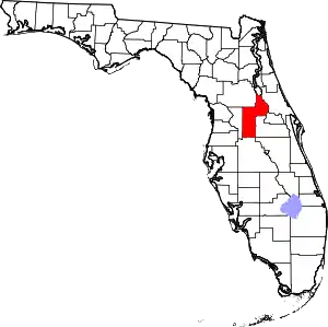
Location of Lake County in Florida
This is intended to be a complete list of the properties and districts on the National Register of Historic Places in Lake County, Florida, United States. The locations of National Register properties and districts for which the latitude and longitude coordinates are included below, may be seen in a map.[1]
There are 31 properties and districts listed on the National Register in the county. One property was once listed, by has since been delisted.
- This National Park Service list is complete through NPS recent listings posted February 5, 2021.[2]
| Alachua - Baker - Bay - Bradford - Brevard - Broward - Calhoun - Charlotte - Citrus - Clay - Collier - Columbia - DeSoto - Dixie - Duval - Escambia - Flagler - Franklin - Gadsden - Gilchrist - Glades - Gulf - Hamilton - Hardee - Hendry - Hernando - Highlands - Hillsborough (Tampa) - Holmes - Indian River - Jackson - Jefferson - Lafayette - Lake - Lee - Leon - Levy - Liberty - Madison - Manatee - Marion - Martin - Miami-Dade (Miami) - Monroe - Nassau - Okaloosa - Okeechobee - Orange - Osceola - Palm Beach - Pasco - Pinellas - Polk - Putnam - St. Johns - St. Lucie - Santa Rosa - Sarasota - Seminole - Sumter - Suwannee - Taylor - Union - Volusia - Wakulla - Walton - Washington |
Current listings
| [3] | Name on the Register[4] | Image | Date listed[5] | Location | City or town | Description |
|---|---|---|---|---|---|---|
| 1 | Blandford | 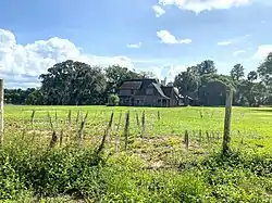 Blandford |
November 1, 2007 (#07001115) |
28242 Lake Terry Drive 28°45′31″N 81°40′14″W |
Mount Dora | |
| 2 | Bowers Bluff Middens Archeological District | February 1, 1980 (#80000952) |
Address Restricted |
Astor | ||
| 3 | Campbell House | 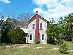 Campbell House |
November 12, 1999 (#99001298) |
3147 County Road 470 28°44′51″N 81°54′04″W |
Okahumpka | |
| 4 | Clermont Woman's Club |  Clermont Woman's Club |
January 7, 1993 (#92001747) |
655 Broome Street 28°33′06″N 81°45′59″W |
Clermont | |
| 5 | Clifford House |  Clifford House |
April 4, 1975 (#75000559) |
536 North Bay Street 28°51′28″N 81°41′11″W |
Eustis | |
| 6 | Donnelly House | 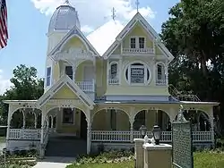 Donnelly House |
April 4, 1975 (#75000560) |
Donnelly Avenue 28°48′02″N 81°38′42″W |
Mount Dora | |
| 7 | Harry C. Duncan House | 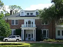 Harry C. Duncan House |
August 8, 1997 (#97000860) |
426 Lake Dora Drive 28°48′04″N 81°43′22″W |
Tavares | |
| 8 | Dyches House |  Dyches House |
September 8, 2014 (#14000552) |
240 E. Lady Lake Blvd. 28°54′57″N 81°54′57″W |
Lady Lake | |
| 9 | Edge House | 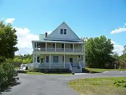 Edge House |
October 5, 2006 (#06000917) |
1218 West Broad Street 28°33′54″N 81°52′15″W |
Groveland | |
| 10 | Eustis Commercial Historic District | 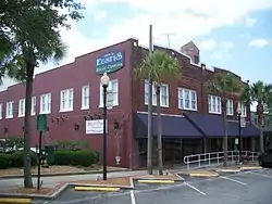 Eustis Commercial Historic District |
July 6, 2005 (#05000654) |
Roughly Lake Eustis, McDonald Avenue, Grove Street, and Orange Avenue 28°51′13″N 81°41′07″W |
Eustis | |
| 11 | Ferran Park and the Alice McClelland Memorial Bandshell | 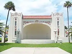 Ferran Park and the Alice McClelland Memorial Bandshell |
June 23, 1994 (#94000625) |
Junction of Ferran Park Road and Orange Avenue 28°51′14″N 81°41′12″W |
Eustis | |
| 11 | Edgar L. Ferran House |  Edgar L. Ferran House |
October 16, 2019 (#100004518) |
310 E. Orange Ave. 28°51′10″N 81°40′56″W |
Eustis | |
| 12 | Harper House | 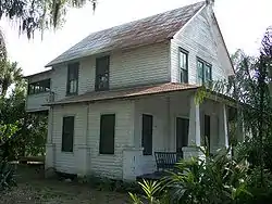 Harper House |
September 15, 2004 (#04000969) |
17408 East Porter Avenue 28°35′55″N 81°40′04″W |
Montverde | |
| 13 | Hill Crest |  Hill Crest |
November 12, 2015 (#15000783) |
511 E. Mirror Lake Dr. 28°51′07″N 81°54′36″W |
Fruitland Park | |
| 14 | Holy Trinity Episcopal Church |  Holy Trinity Episcopal Church |
December 27, 1974 (#74000646) |
Spring Lake Road 28°52′38″N 81°55′01″W |
Fruitland Park | |
| 15 | Howey House | 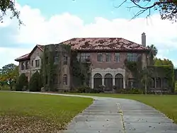 Howey House |
January 27, 1983 (#83001426) |
Citrus Street 28°43′22″N 81°46′30″W |
Howey-in-the-Hills | |
| 16 | Kimball Island Midden Archeological Site | December 11, 1979 (#79000675) |
Address Restricted |
Astor | ||
| 17 | Lake County Courthouse | 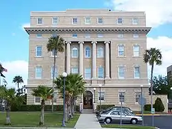 Lake County Courthouse |
September 25, 1998 (#98001199) |
315 West Main Street 28°48′06″N 81°43′52″W |
Tavares | |
| 18 | Lakeside Inn | 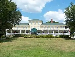 Lakeside Inn |
March 19, 1987 (#87000481) |
100 North Alexander Street 28°47′52″N 81°38′42″W |
Mount Dora | |
| 19 | LaRoe Family Homestead Historic District |  LaRoe Family Homestead Historic District |
June 29, 2009 (#09000493) |
3430 West County Road 44 and 2891 East Orange Avenue 28°51′14″N 81°39′15″W |
Eustis | |
| 20 | Lee School |  Lee School |
February 17, 1995 (#95000024) |
207 North Lee Street 28°48′46″N 81°52′53″W |
Leesburg | |
| 21 | Methodist Episcopal Church, South, at Umatilla | 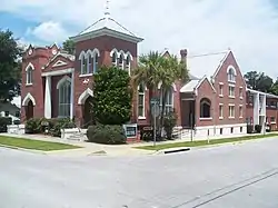 Methodist Episcopal Church, South, at Umatilla |
January 27, 2000 (#99001707) |
100 West Guerrant Street 28°55′39″N 81°40′17″W |
Umatilla | |
| 22 | Mote-Morris House | 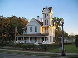 Mote-Morris House |
December 27, 1974 (#74000647) |
1021 North Main Street 28°48′38″N 81°53′02″W |
Leesburg | |
| 23 | Mount Dora Historic District | 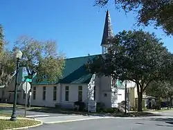 Mount Dora Historic District |
October 1, 2009 (#09000777) |
Roughly 3rd Avenue, 11th Avenue, Clayton Street, and Helen Street 28°48′09″N 81°38′37″W |
Mount Dora | NRHP # 09000777 |
| 24 | Gould Hyde Norton House | 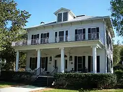 Gould Hyde Norton House |
May 16, 1997 (#97000433) |
1390 East Lakeview Drive 28°50′28″N 81°40′18″W |
Eustis | |
| 25 | Old Mount Dora Atlantic Coast Line Railroad Station | 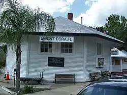 Old Mount Dora Atlantic Coast Line Railroad Station |
March 5, 1992 (#92000099) |
341 Alexander Street 28°47′57″N 81°38′46″W |
Mount Dora | |
| 26 | William Kimbrough Pendleton House | 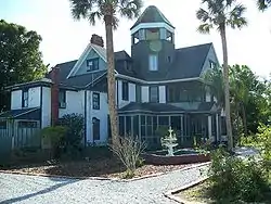 William Kimbrough Pendleton House |
January 13, 1983 (#83001427) |
1208 Chesterfield Road 28°50′26″N 81°40′35″W |
Eustis | |
| 27 | Purdy Villa | 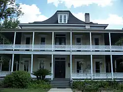 Purdy Villa |
March 10, 2004 (#04000143) |
3045 Eudora Road 28°49′26″N 81°40′26″W |
Eustis | |
| 28 | Moses J. Taylor House |  Moses J. Taylor House |
August 1, 1997 (#97000840) |
117 Diedrich Street 28°51′02″N 81°40′20″W |
Eustis | |
| 29 | Witherspoon Lodge No. 111 Free and Accepted Masons (F&AM) | 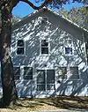 Witherspoon Lodge No. 111 Free and Accepted Masons (F&AM) |
May 21, 2009 (#09000346) |
1410 North Clayton Street 28°48′32″N 81°38′19″W |
Mount Dora | |
| 30 | Woman's Club of Eustis |  Woman's Club of Eustis |
August 5, 1991 (#91001006) |
227 North Center Street 28°51′15″N 81°40′52″W |
Eustis |
Former listing
| [3] | Name on the Register | Image | Date listed | Date removed | Location | City or town | Summary |
|---|---|---|---|---|---|---|---|
| 1 | Fruitland Park Community Center |  Fruitland Park Community Center |
July 24, 2015 (#15000508) | July 24, 2018 | 604 W. Berckman St. 28°51′30″N 81°54′50″W |
Fruitland Park |
See also
| Wikimedia Commons has media related to National Register of Historic Places in Lake County, Florida. |
References
- The latitude and longitude information provided in this table was derived originally from the National Register Information System, which has been found to be fairly accurate for about 99% of listings. Some locations in this table may have been corrected to current GPS standards.
- "National Register of Historic Places: Weekly List Actions". National Park Service, United States Department of the Interior. Retrieved on February 5, 2021.
- Numbers represent an alphabetical ordering by significant words. Various colorings, defined here, differentiate National Historic Landmarks and historic districts from other NRHP buildings, structures, sites or objects.
- "National Register Information System". National Register of Historic Places. National Park Service. March 13, 2009.
- The eight-digit number below each date is the number assigned to each location in the National Register Information System database, which can be viewed by clicking the number.
Municipalities and communities of Lake County, Florida, United States | ||
|---|---|---|
| Cities | | |
| Towns | ||
| CDPs | ||
| Unincorporated communities | ||
| Footnotes | ‡This populated place also has portions in an adjacent county or counties | |
| ||
This article is issued from Wikipedia. The text is licensed under Creative Commons - Attribution - Sharealike. Additional terms may apply for the media files.