National Register of Historic Places listings in Santa Rosa County, Florida
This is a list of the National Register of Historic Places listings in Santa Rosa County, Florida.
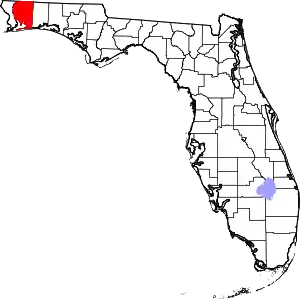
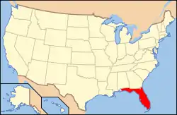
Location of Santa Rosa County in Florida
This is intended to be a complete list of the properties and districts on the National Register of Historic Places in Santa Rosa County, Florida, United States. The locations of National Register properties and districts for which the latitude and longitude coordinates are included below, may be seen in a map.[1]
There are 16 properties and districts listed on the National Register in the county.
- This National Park Service list is complete through NPS recent listings posted January 29, 2021.[2]
| Alachua - Baker - Bay - Bradford - Brevard - Broward - Calhoun - Charlotte - Citrus - Clay - Collier - Columbia - DeSoto - Dixie - Duval - Escambia - Flagler - Franklin - Gadsden - Gilchrist - Glades - Gulf - Hamilton - Hardee - Hendry - Hernando - Highlands - Hillsborough (Tampa) - Holmes - Indian River - Jackson - Jefferson - Lafayette - Lake - Lee - Leon - Levy - Liberty - Madison - Manatee - Marion - Martin - Miami-Dade (Miami) - Monroe - Nassau - Okaloosa - Okeechobee - Orange - Osceola - Palm Beach - Pasco - Pinellas - Polk - Putnam - St. Johns - St. Lucie - Santa Rosa - Sarasota - Seminole - Sumter - Suwannee - Taylor - Union - Volusia - Wakulla - Walton - Washington |
Current listings
| [3] | Name on the Register[4] | Image | Date listed[5] | Location | City or town | Description |
|---|---|---|---|---|---|---|
| 1 | Arcadia Sawmill and Arcadia Cotton Mill |  Arcadia Sawmill and Arcadia Cotton Mill |
August 3, 1987 (#87001300) |
Address Restricted 30°36′35″N 87°05′03″W |
Milton | |
| 2 | Bagdad Village Historic District | 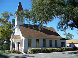 Bagdad Village Historic District |
December 8, 1987 (#87001991) |
Roughly bounded by Main, Water, and Oak Streets, Cobb and Woodville Roads, and Cemetery, Pooley, and School Streets 30°36′01″N 87°02′04″W |
Bagdad | |
| 3 | Bethune Blackwater Schooner | August 8, 1991 (#91000948) |
Address Restricted |
Milton | ||
| 4 | Big Heart West | September 28, 1998 (#98001167) |
Address Restricted |
Gulf Breeze | Part of the Archeological Properties of the Naval Live Oaks Reservation MPS | |
| 5 | Butcherpen Mound | September 28, 1998 (#98001165) |
Address Restricted |
Gulf Breeze | Part of the Archeological Properties of the Naval Live Oaks Reservation MPS | |
| 6 | First American Road in Florida | 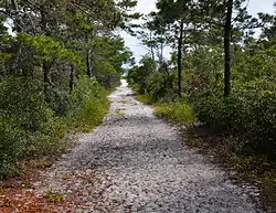 First American Road in Florida |
September 28, 1998 (#98001168) |
Gulf Islands National Seashore-Naval Live Oaks Area 30°22′09″N 87°08′21″W |
Gulf Breeze | Part of the Archeological Properties of the Naval Live Oaks Reservation MPS |
| 7 | Florida State Road No. 1 | 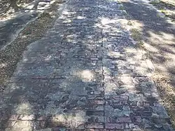 Florida State Road No. 1 |
June 23, 1994 (#94000626) |
Roughly, three sections east of Milton, parallel to U.S. Route 90, between Marquis Bayou and Harold 30°37′54″N 86°59′28″W |
Milton | |
| 8 | Louisville and Nashville Depot |  Louisville and Nashville Depot |
October 29, 1982 (#82001041) |
206 Henry Street 30°37′14″N 87°02′02″W |
Milton | |
| 9 | Milton Historic District | 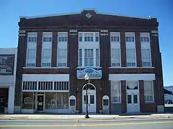 Milton Historic District |
November 12, 1987 (#87001944) |
U.S. Route 90 at the Blackwater River, bounded by Berryhill, Willing, Hill, Canal, Margaret, and Susan Streets 30°37′16″N 87°02′20″W |
Milton | |
| 10 | Mt. Pilgrim African Baptist Church | 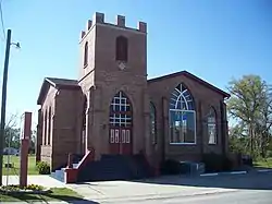 Mt. Pilgrim African Baptist Church |
May 29, 1992 (#92000634) |
Junction of Alice and Clara Streets 30°37′11″N 87°02′26″W |
Milton | |
| 11 | Naval Live Oaks Cemetery | September 28, 1998 (#98001166) |
Address Restricted |
Gulf Breeze | Part of the Archeological Properties of the Naval Live Oaks Reservation MPS | |
| 12 | Naval Live Oaks Reservation | 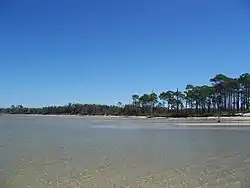 Naval Live Oaks Reservation |
September 28, 1998 (#98001169) |
Gulf Islands National Seashore-Naval Live Oaks Area 30°22′04″N 87°08′24″W |
Gulf Breeze | Part of the Archeological Properties of the Naval Live Oaks Reservation MPS |
| 13 | Ollinger-Cobb House | 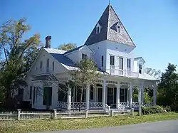 Ollinger-Cobb House |
January 11, 1983 (#83001440) |
302 Pine Street 30°37′09″N 87°02′16″W |
Milton | |
| 14 | St. Mary's Episcopal Church and Rectory | 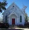 St. Mary's Episcopal Church and Rectory |
May 6, 1982 (#82002380) |
300-301 Oak Street 30°37′16″N 87°02′10″W |
Milton | |
| 15 | Third Gulf Breeze | September 28, 1998 (#98001164) |
Address Restricted |
Gulf Breeze | Part of the Archeological Properties of the Naval Live Oaks Reservation MPS | |
| 16 | Thomas Creek Archeological District | November 4, 1985 (#85003482) |
Address Restricted |
Chumuckla |
See also
| Wikimedia Commons has media related to National Register of Historic Places in Santa Rosa County, Florida. |
References
- The latitude and longitude information provided in this table was derived originally from the National Register Information System, which has been found to be fairly accurate for about 99% of listings. Some locations in this table may have been corrected to current GPS standards.
- "National Register of Historic Places: Weekly List Actions". National Park Service, United States Department of the Interior. Retrieved on January 29, 2021.
- Numbers represent an alphabetical ordering by significant words. Various colorings, defined here, differentiate National Historic Landmarks and historic districts from other NRHP buildings, structures, sites or objects.
- "National Register Information System". National Register of Historic Places. National Park Service. March 13, 2009.
- The eight-digit number below each date is the number assigned to each location in the National Register Information System database, which can be viewed by clicking the number.
Municipalities and communities of Santa Rosa County, Florida, United States | ||
|---|---|---|
| Cities | | |
| Town | ||
| CDPs |
| |
| Unincorporated communities | ||
| ||
This article is issued from Wikipedia. The text is licensed under Creative Commons - Attribution - Sharealike. Additional terms may apply for the media files.