National Register of Historic Places listings in Ventura County, California
This is a list of the National Register of Historic Places listings in Ventura County, California.
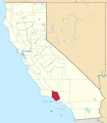
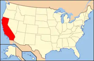
Location of Ventura County in California
This is intended to be a complete list of the properties and districts on the National Register of Historic Places in Ventura County, California, United States. Latitude and longitude coordinates are provided for many National Register properties and districts; these locations may be seen together in an online map.[1]
There are 38 properties and districts listed on the National Register in the county, including 1 National Historic Landmark.
- This National Park Service list is complete through NPS recent listings posted January 29, 2021.[2]
Current listings
| [3] | Name on the Register[4] | Image | Date listed[5] | Location | City or town | Description |
|---|---|---|---|---|---|---|
| 1 | Anacapa Island Archeological District |  Anacapa Island Archeological District |
September 12, 1979 (#79000257) |
Address Restricted |
Port Hueneme | |
| 2 | Anacapa Island Light Station | 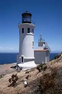 Anacapa Island Light Station |
September 3, 1991 (#91001101) |
Anacapa Island, Channel Islands National Park 34°00′56″N 119°21′39″W |
Oxnard | |
| 3 | Elizabeth Bard Memorial Hospital |  Elizabeth Bard Memorial Hospital |
November 11, 1977 (#77000361) |
121 N. Fir St. 34°16′56″N 119°17′18″W |
Ventura | |
| 4 | Bardsdale Methodist Episcopal Church |  Bardsdale Methodist Episcopal Church |
August 28, 1986 (#86001986) |
1498 Bardsdale Ave. 34°22′17″N 118°55′55″W |
Fillmore | In 1898, a local group of German Evangelical Church Members joined with their friends and neighbors to “Step Out in Faith” and build the carpenter gothic building we now know as the Bardsdale United Methodist Church. |
| 5 | Berylwood |  Berylwood |
September 15, 1977 (#77000360) |
Ventura Rd. 34°09′28″N 119°11′48″W |
Port Hueneme | Bard family's 62-acre (250,000 m2) estate; leased by the Navy during World War II and acquired by the government in 1951 |
| 6 | Burro Flats Site | 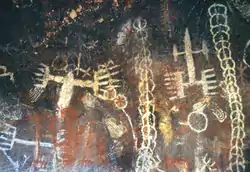 Burro Flats Site |
May 5, 1976 (#76000539) |
Address Restricted |
Bell Canyon | A Cave containing Chumash pictographs near the historic Chumash settlement of Hu'wam along upper Bell Creek. A boundary decrease and renaming was approved July 2, 2020. |
| 7 | Calleguas Creek Site | May 19, 1976 (#76000538) |
Address Restricted |
Oxnard | ||
| 8 | Camarillo Ranch House | 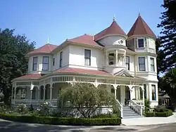 Camarillo Ranch House |
February 20, 2003 (#03000039) |
201 Camarillo Ranch Rd. 34°13′05″N 119°01′02″W |
Camarillo | Fifteen-room house built in 1892 by the Camarillo family, after whom the City of Camarillo is named |
| 9 | Case Study House No. 28 | 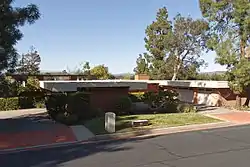 Case Study House No. 28 |
July 24, 2013 (#13000522) |
91 Inverness Rd. 34°10′18″N 118°52′48″W |
Thousand Oaks | Case Study House by Buff and Hensman, built 1966 |
| 10 | Colony House |  Colony House |
September 18, 1978 (#78000824) |
137 Strathearn Pl. 34°16′30″N 118°48′04″W |
Simi Valley | Kit house on display at historical park with Simi Adobe and Strathearn House |
| 11 | Dudley House | 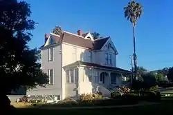 Dudley House |
May 12, 1977 (#77000362) |
4085 Telegraph Rd. 34°16′34″N 119°14′20″W |
Ventura | |
| 12 | Ebell Club of Santa Paula |  Ebell Club of Santa Paula |
July 20, 1989 (#89000949) |
125 S. Seventh St. 34°21′06″N 119°03′51″W |
Santa Paula | |
| 13 | George Washington Faulkner House | 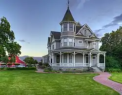 George Washington Faulkner House |
April 25, 1991 (#91000485) |
14292 W. Telegraph Rd. 34°19′32″N 119°06′18″W |
Santa Paula | |
| 14 | Feraud General Merchandise Store | 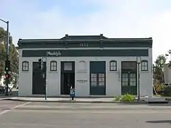 Feraud General Merchandise Store |
January 23, 1986 (#86000109) |
2 and 12 W. Main St. 34°16′51″N 119°18′03″W |
Ventura | Historic bakery, now a bar |
| 15 | First Baptist Church of Ventura |  First Baptist Church of Ventura |
July 3, 2009 (#09000466) |
101 S. Laurel St. 34°16′46″N 119°17′09″W |
Ventura | |
| 16 | Emmanuel Franz House | 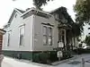 Emmanuel Franz House |
June 25, 1982 (#82002282) |
31 N. Oak St. 34°16′52″N 119°17′38″W |
Ventura | |
| 17 | Glen Tavern Hotel |  Glen Tavern Hotel |
July 26, 1984 (#84001225) |
134 N. Mill St. 34°21′18″N 119°03′40″W |
Santa Paula | |
| 18 | Thomas Gould Jr. House | December 23, 2005 (#05001426) |
402 Lynn Dr. 34°16′47″N 119°14′58″W |
Ventura | ||
| 19 | Grand Union Hotel | 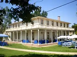 Grand Union Hotel |
December 30, 1975 (#75000495) |
51 Ventu Park Rd. 34°10′41″N 118°54′41″W |
Newbury Park | Originally built in 1876, the structure was destroyed by fire in 1970. It was rebuilt and opened in 1976 as a historical museum, known in recent years as the Stagecoach Inn. |
| 20 | Grandma Prisbrey's Bottle Village | .jpg.webp) Grandma Prisbrey's Bottle Village |
October 25, 1996 (#96001076) |
4595 Cochran St. 34°16′44″N 118°42′14″W |
Simi Valley | Folk art assemblage made out of bottles and other found objects begun in 1956 by Tressa Prisbrey |
| 21 | Joel McCrea Ranch | 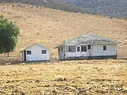 Joel McCrea Ranch |
April 18, 1997 (#97000295) |
4500 N. Moorpark Rd. 34°14′35″N 118°51′24″W |
Thousand Oaks | Working ranch run by actor Joel McCrea from the 1930s to the 1970s |
| 22 | Mission San Buenaventura and Mission Compound Site | 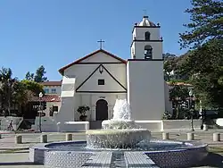 Mission San Buenaventura and Mission Compound Site |
April 10, 1975 (#75000496) |
Bounded by Poli St., Ventura and Santa Clara Aves., and Palm St. 34°16′50″N 119°17′52″W |
Ventura | |
| 23 | Olivas Adobe | .jpg.webp) Olivas Adobe |
July 24, 1979 (#79000570) |
4200 Olivas Park Dr. 34°14′40″N 119°14′28″W |
Ventura | The only early two-story adobe in the Santa Clara River Valley; small one-story adobe built in 1837 was expanded in 1849 by Don Raimundo Olivas |
| 24 | Oxnard Public Library |  Oxnard Public Library |
July 27, 1971 (#71000210) |
424 S. C St. 34°11′54″N 119°10′48″W |
Oxnard | Former Carnegie library converted into an art museum, now known as Carnegie Art Museum |
| 25 | Henry T. Oxnard Historic District | 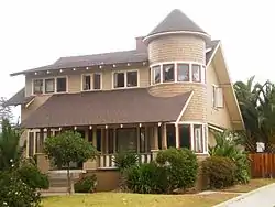 Henry T. Oxnard Historic District |
February 5, 1999 (#99000109) |
F and G Sts., between Palm and 5th Sts. 34°12′01″N 119°11′11″W |
Oxnard | District of historic homes located near downtown Oxnard |
| 26 | Charles M. Pratt House | %252C_California_(NYDA.1987.003.00121).jpg.webp) Charles M. Pratt House |
June 14, 2002 (#00001227) |
1330 Foothill Rd. 34°27′43″N 119°15′18″W |
Ojai | |
| 27 | Rancho Camulos |  Rancho Camulos |
November 1, 1996 (#96001137) |
5164 E. Telegraph Rd. 34°24′18″N 118°45′20″W |
Piru | |
| 28 | St. Thomas Aquinas Chapel | 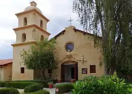 St. Thomas Aquinas Chapel |
June 29, 1995 (#95000785) |
130 W. Ojai Ave. 34°26′53″N 119°14′49″W |
Ojai | |
| 29 | San Buenaventura Mission Aqueduct | 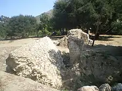 San Buenaventura Mission Aqueduct |
March 7, 1975 (#75000497) |
234 Canada Larga Rd. 34°20′31″N 119°17′23″W |
Ventura | Ruins of 7 mile (11 km) aqueduct built by Native Americans to bring water from the Ventura River to the San Buenaventura Mission |
| 30 | San Miguel Chapel Site | 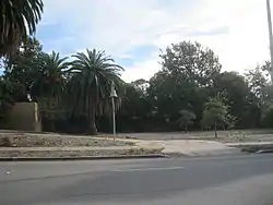 San Miguel Chapel Site |
July 20, 1978 (#78000826) |
Thompson Blvd. and Palm St.[6] 34°16′41″N 119°17′48″W |
Ventura | |
| 31 | Santa Paula Hardware Company Block–Union Oil Company | 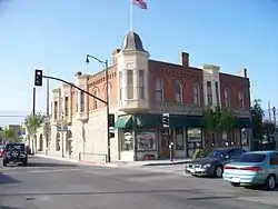 Santa Paula Hardware Company Block–Union Oil Company |
August 14, 1986 (#86002619) |
1003 E. Main St. 34°21′15″N 119°03′32″W |
Santa Paula | |
| 32 | Saticoy Southern Pacific Railroad Depot | 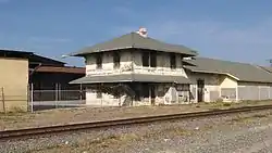 Saticoy Southern Pacific Railroad Depot |
July 23, 2018 (#100002678) |
11220 Azahar St. 34°17′05″N 119°08′47″W |
Saticoy | |
| 33 | Simi Adobe–Strathearn House | 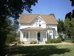 Simi Adobe–Strathearn House |
May 19, 1978 (#78000825) |
137 Strathearn Pl. 34°16′30″N 118°48′01″W |
Simi Valley | Old adobe and Victorian house built in 1892 that were the homestead of the Rancho Simi |
| 34 | SS WINFIELD SCOTT (Steamship) | 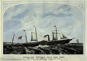 SS WINFIELD SCOTT (Steamship) |
September 12, 1988 (#87002111) |
Address Restricted |
Anacapa Island | Shipwreck. |
| 35 | Thacher School Historic District | April 4, 2019 (#100003579) |
5025 Thacher Rd. 34°27′50″N 119°10′55″W |
Ojai | ||
| 36 | Ventura County Courthouse | 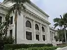 Ventura County Courthouse |
August 19, 1971 (#71000211) |
501 Poli St. 34°16′57″N 119°17′32″W |
Ventura | |
| 37 | Ventura Theatre | 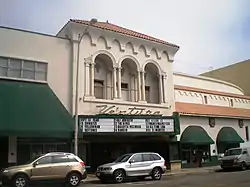 Ventura Theatre |
December 29, 1986 (#86003523) |
26 S. Chestnut 34°16′50″N 119°17′26″W |
Ventura | Historic theater now a popular music venue in downtown Ventura |
| 38 | Women's Improvement Club of Hueneme | 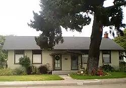 Women's Improvement Club of Hueneme |
August 21, 1989 (#89001150) |
239 E. Scott St. 34°08′58″N 119°11′48″W |
Port Hueneme |
See also
| Wikimedia Commons has media related to National Register of Historic Places in Ventura County, California. |
References
- The latitude and longitude information provided in this table was derived originally from the National Register Information System, which has been found to be fairly accurate for about 99% of listings. Some locations in this table may have been corrected to current GPS standards.
- "National Register of Historic Places: Weekly List Actions". National Park Service, United States Department of the Interior. Retrieved on January 29, 2021.
- Numbers represent an alphabetical ordering by significant words. Various colorings, defined here, differentiate National Historic Landmarks and historic districts from other NRHP buildings, structures, sites or objects.
- "National Register Information System". National Register of Historic Places. National Park Service. July 9, 2010.
- The eight-digit number below each date is the number assigned to each location in the National Register Information System database, which can be viewed by clicking the number.
- "City Map - Public Version - Parks Configuration". City of Ventura. Archived from the original on August 19, 2012. Retrieved July 6, 2013.
| Lists by county |
|  |
|---|---|---|
| Lists by city |
| |
| Other lists | ||
Municipalities and communities of Ventura County, California, United States | ||
|---|---|---|
| Cities | Ventura County map | |
| CDPs | ||
| Unincorporated communities | ||
| Footnotes | ‡This populated place also has portions in an adjacent county or counties | |
| ||
This article is issued from Wikipedia. The text is licensed under Creative Commons - Attribution - Sharealike. Additional terms may apply for the media files.