Northern United States
The Northern United States, commonly referred to as the American North, the Northern States, or simply the North, is a geographical or historical region of the United States.
Northern United States | |
|---|---|
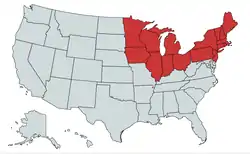 The states shown in red are included in the general term Northern United States. | |
| Country | |
| States |
|
| Area | |
| • Total | 625,897.06 sq mi (1,621,065.9 km2) |
| • Land | 540,298.08 sq mi (1,399,365.6 km2) |
| Population (2019 est.)[2] | |
| • Total | 111,736,936 |
| • Density | 180/sq mi (69/km2) |
Geographic term
Geographically, the term includes the U.S. states and regions of the United States of America that are located across the northernmost part of the country. It includes, but is not limited to, states along the Canada–United States border.
Census Bureau
The United States Census Bureau divides some of the northernmost United States into the Midwest Region and the Northeast Region.[3] The Census Bureau also includes the northernmost states of the Northwest, that are within the West Region.[3]
Historical term
Before 19th-century westward expansion, the "Northern United States" corresponded to the present day New England region. By the 1830s it corresponded to the present day Northeast.
Before 1865, the North was distinguished from the South on the issue of slavery. In Southern states, slavery was legal until the ratification of the Emancipation Proclamation in 1865. Northern states had all passed some form of legislation to abolish slavery by 1804. However, abolition did not mean freedom for some existing slaves. Due to gradual abolition laws, slaves would still appear in some Northern states as far as the 1840 United States Census.[4] Slavery would ultimately lead to the main cause of the American Civil War.
American Civil War
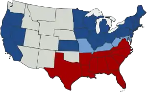
During the American Civil War, the Northern United States was composed of the U.S. states that supported the United States of America, the Union states. In this context, "The North" is synonymous with the Union. In this context, "The South" is composed of the states that attempted secession from the U.S. to form the Confederate States of America. However, which states comprised "The North" in this context can be the subject of historical disagreement. Five slave-holding states, called the Border states, that remained with the Union – Missouri, Kentucky, West Virginia, Maryland, and Delaware (along with the disputed Indian Territory) – may be included in either region.[5]
See also
- Northern Tier (United States)
- Flora of the Northern United States
- Southern United States
- Southeastern United States
- Southwestern United States
- Yankee
References
- "United States Summary: 2010, Population and Housing Unit Counts, 2010 Census of Population and Housing" (PDF). United States Census Bureau. September 2012. pp. V–2, 1 & 41 (Tables 1 & 18). Retrieved February 7, 2014.
- "Population, Population Change, and Estimated Components of Population Change: April 1, 2010 to July 1, 2019 (NST-EST2019-alldata)". Census.gov. United States Census Bureau. Archived from the original on January 26, 2020. Retrieved 8 February 2020.
- "Census Regions and Divisions of the United States" (PDF). United States Census Bureau. Archived from the original (PDF) on 2013-01-07. Retrieved 2009-10-27.
- Klein, Christopher. (Feb 5, 2019). Deeper Roots of Northern Slavery Unearthed - HISTORY. Retrieved Jul 28, 2020.
- "the North (region, United States)". Encyclopædia Britannica Online. 2009. Retrieved 2009-10-27.