Mountain states
The Mountain States (also known as the Mountain West or the Interior West) form one of the nine geographic divisions of the United States that are officially recognized by the United States Census Bureau. It is a subregion of the Western United States.

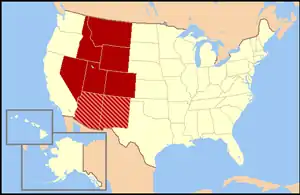
The Mountain States generally are considered to include: Arizona, Colorado, Idaho, Montana, Nevada, New Mexico, Utah and Wyoming. The words "Mountain States" generally refer to the US States which encompass the US Rocky Mountains. These are oriented north-south through portions of the states of Montana, Idaho, Wyoming, Colorado, Utah and New Mexico. Arizona and Nevada, as well as other parts of Utah and New Mexico, have other smaller mountain ranges and scattered mountains located in them as well. Sometimes, the Trans-Pecos area of West Texas is considered part of the region. The land area of the eight states together is some 855,767 square miles (2,216,426 square kilometers).
A few Subregions exist within this region:
- The Southwest region consisting of Arizona, New Mexico, Southern Nevada and Far West Texas[1]
- The Intermountain region consisting of Utah, Nevada, Idaho along with portions of other states[2]
- The Front Range region consisting of Northern New Mexico, Colorado and Southeast Wyoming[3]
Regional geography
The Mountain West is one of the largest and most diverse regions in the United States. Most regional boundaries of the Mountain West are often looked at the area from the High Plains to the Sierra Nevada and the Cascade Range. The southern and northern portions of the Mountain West are often split into two separate regions. The southern portion (Arizona and New Mexico) is often called the Southwest region, while the northern portion (Idaho and Montana) is often included in either the Northwest states or called the "Northern Rockies".[4]
Terrain
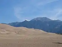
Together with the Pacific States of Alaska, California, Hawaii, Oregon and Washington, the Mountain States constitute the broader region of the West, one of the four regions the United States Census Bureau formally recognizes (the Northeast, South and Midwest being the other three). The terrain of the Mountain West is more diverse than any other region in the United States. Its physical geography ranges from some of the highest mountain peaks in the continental United States to large desert lands and rolling plains in the eastern portion of the region. The Mountain West states contain all of the major deserts found in North America. The Great Basin Desert is located in almost all of Nevada, western Utah and southern Idaho. Portions of the Mojave Desert are located in California, but over half of the desert is located in southern Nevada, in the Mountain West. Meanwhile, the Sonoran Desert is located in much of Arizona, and the Chihuahuan Desert is located in most of southwestern and southern New Mexico, including White Sands and Jornada del Muerto. Colorado also has scattered desert lands in the southern and northwestern portions of the state, including the expansive San Luis Valley.
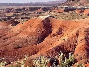
Colorado, New Mexico, Utah, and Arizona have other smaller desert lands, part of the Colorado Plateau. The Painted Desert is located in northern and northeastern Arizona, and the San Rafael Desert is located in eastern Utah. New Mexico has other desert lands located in the northern and northwest. Colorado has large desert lands on the colorado plateau in the northwestern, western, and southern parts of the state. These desert lands in Colorado are located in and around areas such as Royal Gorge, Great Sand Dunes National Park, Pueblo, the San Luis Valley, Cortez, Dove Creek, Delta, Canyons of the Ancients National Monument, the Roan Plateau, Dinosaur National Monument, Colorado National Monument and the Grand Mesa.[5] The San Luis Valley is the largest high valley desert in the world.hi
In the far-eastern portions of the Mountain West are the High Plains, a portion of the Great Plains. These plains mainly consist of flat rolling land, with scattered buttes, canyons, and forests located in these areas. The High Plains receive very little rainfall and sit at high elevations, usually about 3,000 to 6,000 feet (910 to 1,830 m). Many people view the High Plains as the point where one begins to enter the greater Mountain West region.[6]
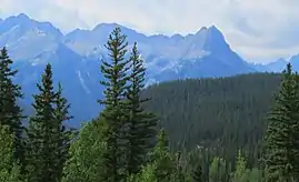
The Mountain West has some of the highest mountain peaks in America. Some of the more famous mountains in the Mountain West are Mount Elbert, Pikes Peak, Blanca Peak, Longs Peak, Kings Peak, Wind River Peak, Cloud Peak, Wheeler Peak, Truchas Peak, Granite Peak, Borah Peak and Humphreys Peak.[7]
Climate
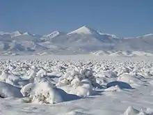
The climate of the Mountain West is one of the more diverse climates in the United States. The entire region generally features a semi-arid to the arid climate, with some alpine climates in the mountains of each state. Some parts of the tall mountains can receive very large amounts of snow and rain, while other parts of the region received very little rain, and virtually no snow at all. The High Plains in the eastern portion of the region receive moderate snowfalls, but very little rain.
The states of Nevada and Arizona are generally filled with desert lands and scattered mountain ranges. Much of Nevada receives little to no snow in the southern portion of the state, while northern Nevada can receive large amounts of snow in and around the mountains, and even in the desert lands in Nevada. Arizona generally receives little rain or snow, but high elevations in and near mountains receive extremely large amounts of rain and snow. Northern and northeastern Arizona display characteristics of a "High Desert", where the summers are very hot and dry, while the winters can become very cold, and it can snow as well.
Utah is also generally large desert lands, with mountains as well. However, the desert lands in Utah receive significant snowfall, and there are large amounts of snowfall on and around the mountains. Colorado and New Mexico have very similar climates. Both states can receive significant snowfalls off the mountains, while the mountains in both states receive extremely large amounts of snow. However, southern and southwestern New Mexico generally does not receive much snow at all, similar to southern Nevada and southern Arizona. The desert lands found in northeastern Arizona, eastern Utah, northern New Mexico, and western and southern Colorado are generally referred to as the "High Desert" lands.
The northern portion of the Mountain West tends to be a bit cooler than the southwestern areas. Idaho and Montana both receive significant snowfalls off the mountains and very large snowfalls in the mountains. The High Desert also exists in the northern Mountain West. Southeastern Oregon and southern Idaho have the Great Basin Desert lands located in them, which is part of the high desert.[8]
The eight Mountain States have the highest mean elevations of all 50 U.S. states.
States

| Rank | State | Highest point | Highest elevation | Lowest point | Lowest elevation | Mean elevation | Elevation span |
|---|---|---|---|---|---|---|---|
| 1 | Colorado | Mount Elbert[10] | 14,440 ft 4401 m |
Arikaree River at Kansas border | 3,317 ft 1011 m |
6,800 ft 2073 m |
11,123 ft 3390 m |
| 2 | Wyoming | Gannett Peak[11] | 13,809 ft 4209 m |
Belle Fourche River at South Dakota border | 3,100 ft 945 m |
6,693 ft 2040 m |
10,709 ft 3264 m |
| 3 | Utah | Kings Peak[12] | 13,518 ft 4120 m |
Beaver Dam Wash at Arizona border | 2,180 ft 664 m |
6,100 ft 1859 m |
11,338 ft 3456 m. |
| 4 | New Mexico | Wheeler Peak[13] | 13,167 ft 4013 m |
Red Bluff on Texas border | 2,842 ft 866 m |
5,700 ft 1737 m |
10,325 ft 3147 m |
| 5 | Nevada | Boundary Peak[14] | 13,147 ft 4007 m |
Colorado River at California border | 479 ft 146 m |
5,500 ft 1676 m |
12,668 ft 3861 m |
| 6 | Idaho | Borah Peak[15] | 12,668 ft 3861 m |
Snake River at Washington border | 710 ft 216 m |
5,000 ft 1524 m |
11,958 ft 3645 m |
| 7 | Arizona | Humphreys Peak[16] | 12,637 ft 3852 m |
Colorado River at Sonora border | 70 ft 21 m |
4,100 ft 1250 m |
12,567 ft 3830 m |
| 8 | Montana | Granite Peak[17] | 12,807 ft 3904 m |
Kootenai River at Idaho border. | 1,800 ft 549 m |
3,400 ft 1036 m |
11,007 ft 3355 m |
| Mountain States | Mount Elbert[10] | 14,440 ft 4401 m |
Colorado River at Sonora border. | 70 ft 21 m |
5,400 ft 1646 m. |
14,370 ft 4380 m. | |
Cities
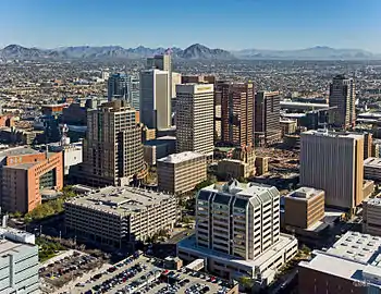
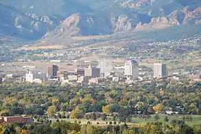
The Phoenix metropolitan area is the most populous metropolitan area of the Mountain States, followed by Denver, Las Vegas and Salt Lake City. Phoenix is also the most populous city.


The following table is a ranking of Rocky Mountain cities by city population.
| Rank | City | State | 2014 pop est | 2010 pop | Change |
|---|---|---|---|---|---|
| 1 | Phoenix | Arizona | 1,537,058 | 1,445,632 | +6.32% |
| 2 | Denver | Colorado | 663,862 | 600,158 | +10.61% |
| 3 | Las Vegas | Nevada | 613,599 | 583,756 | +5.11% |
| 4 | Albuquerque | New Mexico | 557,169 | 545,852 | +2.07% |
| 5 | Tucson | Arizona | 527,972 | 520,116 | +1.51% |
| 6 | Mesa | Arizona | 464,704 | 439,041 | +5.85% |
| 7 | Colorado Springs | Colorado | 445,830 | 416,427 | +7.06% |
| 8 | Aurora | Colorado | 353,108 | 325,078 | +8.62% |
| 9 | Henderson | Nevada | 277,440 | 257,729 | +7.65% |
| 10 | Chandler | Arizona | 254,276 | 236,123 | +7.69% |
| 11 | Gilbert | Arizona | 239,277 | 208,453 | +14.79% |
| 12 | Glendale | Arizona | 237,517 | 226,721 | +4.76% |
| 13 | Reno | Nevada | 236,995 | 225,221 | +5.23% |
| 14 | North Las Vegas | Nevada | 230,788 | 216,961 | +6.37% |
| 15 | Scottsdale | Arizona | 230,512 | 217,385 | +6.04% |
| 16 | Boise | Idaho | 216,282 | 205,671 | +5.16% |
| 17 | Salt Lake City | Utah | 190,884 | 186,440 | +2.38% |
| 18 | Tempe | Arizona | 172,816 | 161,719 | +6.86% |
| 19 | Peoria | Arizona | 166,934 | 154,065 | +8.35% |
| 20 | Fort Collins | Colorado | 156,480 | 143,986 | +8.68% |
| 21 | Lakewood | Colorado | 149,643 | 142,980 | +4.66% |
| 22 | West Valley City | Utah | 134,495 | 129,480 | +3.87% |
| 23 | Thornton | Colorado | 130,307 | 118,772 | +9.71% |
| 24 | Surprise | Arizona | 126,275 | 117,517 | +7.45% |
| 25 | Provo | Utah | 114,801 | 112,488 | +2.06% |
| 26 | Arvada | Colorado | 113,574 | 106,433 | +6.71% |
| 27 | Westminster | Colorado | 112,090 | 106,114 | +5.63% |
| 28 | West Jordan | Utah | 110,920 | 103,712 | +6.95% |
| 29 | Billings | Montana | 108,869 | 104,170 | +4.51% |
| 30 | Pueblo | Colorado | 108,423 | 106,595 | +1.71% |
Census statistical areas


| Rank | CBSA | 2014 pop est | 2010 pop | Change |
|---|---|---|---|---|
| 1 | Phoenix–Mesa–Scottsdale, AZ MSA | 4,489,109 | 4,192,887 | +7.06% |
| 2 | Greater Denver Metropolitan Area | 3,345,261 | 3,090,874 | +8.23% |
| 3 | Las Vegas–Henderson-Paradise, NV MSA | 2,069,681 | 1,951,269 | +6.07% |
| 4 | Salt Lake City, UT MSA | 1,153,340 | 1,124,197 | +2.59% |
| 5 | Tucson, AZ MSA | 1,004,516 | 980,263 | +2.47% |
| 6 | Albuquerque, NM MSA | 904,587 | 887,077 | +1.97% |
| 7 | Colorado Springs, CO MSA | 686,908 | 645,613 | +6.40% |
| 8 | Boise City, ID MSA | 664,422 | 616,561 | +7.76% |
| 9 | Ogden-Clearfield, UT MSA | 632,293 | 597,159 | +5.88% |
| 10 | Provo-Orem, UT MSA | 571,460 | 526,810 | +8.48% |
| 11 | Reno, NV MSA | 443,990 | 425,417 | +4.37% |
| 12 | Fort Collins, CO MSA | 324,122 | 299,630 | +8.17% |
| 13 | Boulder, CO MSA | 313,333 | 294,567 | +6.37% |
| 14 | Greeley, CO MSA | 277,670 | 252,825 | +9.83% |
| 15 | Prescott, AZ MSA | 218,844 | 211,033 | +3.70% |
| 16 | Las Cruces, NM MSA | 213,676 | 209,233 | +2.12% |
| 17 | Lake Havasu City-Kingman, AZ MSA | 203,361 | 200,186 | +1.59% |
| 18 | Yuma, AZ MSA | 203,247 | 195,751 | +3.83% |
| 19 | Billings, MT MSA | 166,885 | 158,050 | +5.59% |
| 20 | Pueblo, CO MSA | 161,875 | 159,063 | +1.77% |
| 21 | Saint George, UT MSA | 151,948 | 138,115 | +10.02% |
| 22 | Grand Junction, CO MSA | 148,255 | 146,723 | +1.04% |
| 23 | Santa Fe, NM MSA | 148,164 | 144,170 | +2.77% |
| 24 | Coeur d'Alene, ID MSA | 147,326 | 138,494 | +6.38% |
| 25 | Idaho Falls, ID MSA | 138,266 | 130,374 | +6.05% |
| 26 | Flagstaff, AZ MSA | 137,682 | 134,421 | +2.43% |
| 27 | Logan, UT-ID MSA | 131,364 | 125,442 | +4.72% |
| 28 | Sierra Vista-Douglas, AZ MSA | 127,448 | 131,346 | −2.97% |
| 29 | Farmington, NM MSA | 123,785 | 130,044 | −4.81% |
| 30 | Missoula, MT MSA | 112,684 | 109,299 | +3.10% |
| Rank | CSA | 2014 pop | 2010 pop | Change | Component CBSAs |
|---|---|---|---|---|---|
| 1 | Denver-Aurora, CO CSA | 3,345,261 | 3,090,874 | +8.23% | Boulder, CO MSA Denver–Aurora–Lakewood, CO MSA Greeley, CO MSA |
| 2 | Salt Lake City-Provo-Orem, UT CSA | 2,423,912 | 2,271,696 | +6.70% | Heber, UT µSA Ogden-Clearfield, UT MSA Provo-Orem, UT MSA Salt Lake City, UT MSA |
| 3 | Las Vegas-Henderson, NV-AZ CSA | 2,315,324 | 2,195,401 | +5.46% | Lake Havasu City-Kingman, AZ MSA Las Vegas-Henderson-Paradise, NV MSA Pahrump, NV µSA |
| 4 | Albuquerque-Santa Fe-Las Vegas, NM Combined Statistical Area | 1,165,798 | 1,146,049 | +1.72% | Albuquerque MSA Espanola, NM µSA Grants, NM µSA Las Vegas, NM µSA Los Alamos, NM µSA Santa Fe, NM MSA |
| 5 | Tucson-Nogales, AZ CSA | 1,051,211 | 1,027,683 | +2.29% | Nogales, AZ µSA Tucson, AZ MSA |
| 6 | Boise City-Mountain Home-Ontario, ID-OR CSA | 743,711 | 697,535 | +6.62% | Boise City, ID MSA Mountain Home, ID µSA Ontario, OR-ID µSA |
| 7 | Reno-Carson City-Fernley, NV CSA | 597,837 | 579,668 | +3.13% | Carson City, NV MSA Fernley, NV µSA Gardnerville Ranchos, NV µSA Reno-Sparks, NV MSA |
| 8 | Idaho Falls-Rexburg-Blackfoot, ID CSA | 234,440 | 229,650 | +2.09% | Idaho Falls, ID MSA Blackfoot, ID µSA Rexburg, ID µSA |
| 9 | Pueblo-Cañon City, CO CSA | 208,377 | 205,887 | +1.21% | Cañon City, CO µSA Pueblo, CO MSA |
| 10 | Edwards-Glenwood Springs, CO CSA | 128,008 | 125,734 | +1.81% | Edwards, CO µSA Glenwood Springs, CO µSA |
| 11 | Clovis-Portales, NM CSA | 70,505 | 68,222 | +3.35% | Clovis, NM µSA Portales, NM µSA |
| 12 | Steamboat Springs-Craig, CO Combined Statistical Area | 36,793 | 37,304 | −1.37% | Craig, CO µSA Steamboat Springs, CO µSA |
Gallery
.jpg.webp) Bell Rock near Sedona, Arizona
Bell Rock near Sedona, Arizona

 The Cliff Palace in Mesa Verde National Park in Colorado
 The rugged San Juan Mountains in Colorado
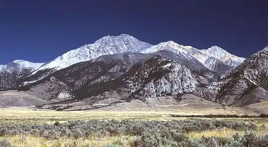 Borah Peak is the highest point in the state of Idaho.
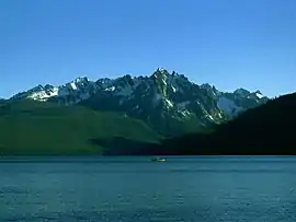 Redfish Lake in Idaho
.jpg.webp) Shoshone Falls on the Snake River in Idaho, 1898
Shoshone Falls on the Snake River in Idaho, 1898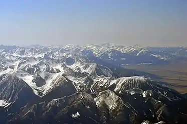 The Absaroka Range of Montana.
 Autumn comes to Chief Mountain in Glacier National Park in Montana
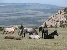 Feral horses in the Pryor Mountain Wild Horse Range in Montana
 Saint Mary Lake in Glacier National Park in Montana
 Stella Lake in Great Basin National Park in Nevada
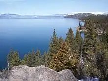 The Nevada shore of Lake Tahoe
 Downtown Reno, Nevada
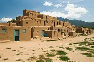 The Taos Pueblo of New Mexico.
 The Very Large Array near Socorro, New Mexico
 Moonrise at White Sands National Park in New Mexico
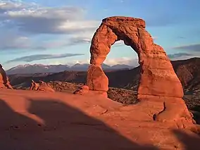
 The Bonneville Salt Flats in Utah
 Mesa Arch in Canyonlands National Park in Utah
Politics
| Parties | ||
| Democratic | Republican | Populist |
- Bold denotes election winner.
Time zones
Mountain Time is observed in nearly the entire division, except Nevada (all but the stateline city of West Wendover) and the Idaho Panhandle. With the exception of West Wendover and Jackpot, Nevada, the entire state of Nevada, along with the Idaho Panhandle, observes Pacific Time. Daylight saving time is not observed in Arizona, except for lands within the Navajo Nation (northeast corner of the state) which observe daylight saving time due to the Nation traversing state lines. For this reason, most of Arizona is one hour behind the rest of the Mountain Time Zone from the second Sunday in March until the first Sunday in November.[22]
See also
- Mountain Time Zone
- Rocky Mountains
- Mountain peaks of the Rocky Mountains
- United States
- List of Combined Statistical Areas
- List of Core Based Statistical Areas
- List of Metropolitan Statistical Areas
- List of Micropolitan Statistical Areas
- U.S. state
- Western United States
References
- "The Southwest Defined". jsw.library.arizona.edu. Retrieved March 21, 2020.
- Blake, Reed H. (2002). The Intermountain West : a story of a place and people. Boston, MA: Pearson Custon Pub. ISBN 0-536-66915-5. OCLC 51680869.
- "Front Range - America 2050". www.america2050.org. Retrieved March 21, 2020.
- "Chapter 9 - THE MOUNTAIN WEST AND SOUTHWEST". Geography: USA. Archived from the original on June 14, 2010. Retrieved February 25, 2011.
- The Shifting Terrain of the Mountain West Archived July 7, 2011, at the Wayback Machine. Research.allacademic.com (May 7, 2013). Retrieved on 2013-07-17.
- Welcome - High Plains Regional Climate Center. Hprcc.unl.edu (June 13, 2013). Retrieved on 2013-07-17.
- Private Tutor. Infoplease.com. Retrieved on July 17, 2013.
- North American Deserts. DesertUSA. Retrieved on July 17, 2013.
- See the List of U.S. states by elevation.
- "Mount Elbert". NGS data sheet. U.S. National Geodetic Survey. Retrieved October 20, 2011.
- "Gannett Peak Cairn". NGS data sheet. U.S. National Geodetic Survey. Retrieved October 20, 2011.
- "Kings Peak Target". NGS data sheet. U.S. National Geodetic Survey. Retrieved October 20, 2011.
- "Wheeler". NGS data sheet. U.S. National Geodetic Survey. Retrieved October 20, 2011.
- "Boundary". NGS data sheet. U.S. National Geodetic Survey. Retrieved October 20, 2011.
- "Beauty Reset". NGS data sheet. U.S. National Geodetic Survey. Retrieved October 20, 2011.
- "Frisco". NGS data sheet. U.S. National Geodetic Survey. Retrieved October 20, 2011.
- "Granite Peak". NGS data sheet. U.S. National Geodetic Survey. Retrieved October 20, 2011.
- "Annual Estimates of the Resident Population for Incorporated Places of 50,000 or More, Ranked by July 1, 2014, Population: April 1, 2010, to July 1, 2014". The American FactFinder. United States Census Bureau, Population Division. Archived from the original on February 13, 2020. Retrieved August 14, 2015.
- "Annual Estimates of the Resident Population: April 1, 2010, to July 1, 2014 - United States -- Metropolitan and Micropolitan Statistical Area; and for Puerto Rico". The American FactFinder. United States Census Bureau, Population Division. Archived from the original on February 12, 2020. Retrieved August 14, 2015.
- "Annual Estimates of the Resident Population: April 1, 2010, to July 1, 2014 - United States -- Combined Statistical Area; and for Puerto Rico". The American FactFinder. United States Census Bureau, Population Division. Archived from the original on February 12, 2020. Retrieved August 14, 2015.
- "OMB Bulletin No. 13-01: Revised Delineations of Metropolitan Statistical Areas, Micropolitan Statistical Areas, and Combined Statistical Areas, and Guidance on Uses of the Delineations of These Areas" (PDF). whitehouse.gov. Office of Management and Budget. February 28, 2013. Archived from the original (PDF) on April 8, 2016. Retrieved August 15, 2015.
- Gettings, John; Brunner, Borgna (April 21, 2018). "Daylight Saving Time". InfoPlease.
External links
| Wikimedia Commons has media related to Mountain states. |
| Wikivoyage has a travel guide for Rocky Mountains (United States of America). |