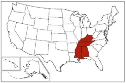
East South Central states
The East South Central states constitute one of the nine Census Bureau Divisions of the United States.
East South Central | |
|---|---|
 A map of the United States Census Bureau Region 3, Division 6, "East South Central", consisting of the states of Alabama, Kentucky, Mississippi and Tennessee. | |
| Area | |
| • Total | 183,403.90 sq mi (475,013.9 km2) |
| • Land | 178,289.84 sq mi (461,768.6 km2) |
| • Water | 5,114.07 sq mi (13,245.4 km2) |
| Population (2019)[2] | |
| • Total | 19,176,181 |
| • Density | 100/sq mi (40/km2) |
Four states make up the division: Alabama, Kentucky, Mississippi and Tennessee. The division is one of three that together make up the larger Census Bureau Region known as the South (the other two of which are the South Atlantic states and the West South Central states).
The East South Central States form the core of Old Dixie, one of the nine moral regions identified by James Patterson and Peter Kim in their acclaimed 1991 geopolitical best-seller, The Day America Told The Truth.
Demographics
As of 2010, the East South Central states had a combined population of 19,176,181. The East South Central region covers 183,401 square miles of land.
| State | 2019 Estimate | Land Area |
|---|---|---|
| Alabama | 4,903,185 | 52,419 |
| Kentucky | 4,467,673 | 40,409 |
| Mississippi | 2,976,149 | 48,430 |
| Tennessee | 6,829,174 | 42,143 |
| City | 2019 Pop. | |
|---|---|---|
| 1 | Nashville, Tennessee | 670,820 |
| 2 | Memphis, Tennessee | 651,073 |
| 3 | Louisville, Kentucky | 617,638 |
| 4 | Lexington, Kentucky | 323,152 |
| 5 | Birmingham, Alabama | 209,423 |
| 6 | Huntsville, Alabama | 200,574 |
| 7 | Montgomery, Alabama | 198,525 |
| 8 | Mobile, Alabama | 188,720 |
| 9 | Knoxville, Tennessee | 187,603 |
| 10 | Chattanooga, Tennessee | 182,799 |
Politics in the East South Central states
| Parties | ||||||||
| Nonpartisan | Democratic-Republican | Democratic | National Republican | Whig | Constitutional Union | Republican | Dixiecrat | American Independent |
- Bold denotes election winner.
References
- "United States Summary: 2010, Population and Housing Unit Counts, 2010 Census of Population and Housing" (PDF). United States Census Bureau. September 2012. pp. V–2, 1 & 41 (Tables 1 & 18). Retrieved February 7, 2014.
- "Population, Population Change, and Estimated Components of Population Change: April 1, 2010 to July 1, 2019 (NST-EST2019-alldata)". Census.gov. United States Census Bureau. Archived from the original on January 26, 2020. Retrieved February 8, 2020.
This article is issued from Wikipedia. The text is licensed under Creative Commons - Attribution - Sharealike. Additional terms may apply for the media files.