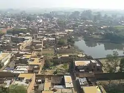
Phooli
Phooli (Hindi: फुली),village is located between Dildarnagar and Zamania in Ghazipur district in the Indian state of Uttar Pradesh. The village is close to the Ganges river.
Phooli
Phooli फूली . | |
|---|---|
Village | |
| Phuli t Chaudhari Azmal | |
 | |
 Phooli Location in Uttar Pradesh, India | |
| Coordinates: 25.429734°N 83.619161°E | |
| Country | |
| State | Uttar Pradesh |
| District | Ghazipur |
| Government | |
| • Type | Panchayat |
| • Body | Gram Pradhan (Aarti Yadav) |
| Area | |
| • Total | 668.03 ha (1,650.74 acres) |
| Elevation | 58 m (190 ft) |
| Population (2011) | |
| • Total | 9,374 |
| • Density | 1,400/km2 (3,600/sq mi) |
| Languages | |
| • Official | Bhojpuri |
| Time zone | UTC+5:30 (IST) |
| PIN | 232329 |
| Telephone code | 05497 |
| Vehicle registration | up-61 |
| Sex ratio | male 57% female 43% ♂/♀ |
| Distance from New Delhi | 870 kilometres (540 mi) NW (land) |
| Distance from Mumbai | 1,576 kilometres (979 mi) SW (land) |
| Distance from Chennai | 1,903 kilometres (1,182 mi) SE (land) |
| Distance from Kolkata | 718 kilometres (446 mi) (land) |
| Climate | Cfa (Köppen) |
| Precipitation | 980 millimetres (39 in) |
| Avg. annual temperature | 32.0 °C (89.6 °F) |
| Avg. summer temperature | 33.0 °C (91.4 °F) |
| Avg. winter temperature | 33 °C (91 °F) |
Phooli is a very old village, it is one of the oldest in Ghazipur district. Phooli has a bus station on the main road route between Zamania and Bara. The people of the village are primarily Hindu and Muslim. The common languages used are Hindi and Bhojpuri, with Bhojpuri being the day-to-day language.
As of the 2011 Census of India, Phooli had a population of 9374.[1] Males constituted 57% of the population and females 43%. Phooli has an average literacy rate of 53%, lower than the national average of 59.5%: male literacy is 69%, and female literacy is 48%. In Phooli, 20% of the population is under 6 years of age.
Phooli provides the main primary facilities, including a market, schools, a hospital and transport. The main market is Haulia chowk, where road transport can be hired. The village has 2500 ration cards.
Government and private schools include the Sri M.A.D.A.P.V. school and the Shree Aditya Lal Janata Yoges High school.

References
- "Census of India 2001: Data from the 2001 Census, including cities, villages and towns (Provisional)". Census Commission of India. Archived from the original on 16 June 2004. Retrieved 1 November 2008.