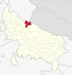
Pilibhit district
Pilibhit district is one of the districts in the state of Uttar Pradesh in India, and Pilibhit city is the district headquarters. Pilibhit district is a part of Bareilly Division. A new Tiger Reserve Area was named Pilibhit Tiger Reserve in September 2008.
Pilibhit District | |
|---|---|
Districts of Uttar Pradesh | |
| Nickname(s): बांसुरी नगरी | |
 Pilibhit District In Uttar Pradesh | |
| Country | |
| State | Uttar Pradesh |
| Headquarters | Pilibhit |
| Division | Bareilly |
| Region | Rohilkhand |
| Area | |
| • Total | 3,504 km2 (1,353 sq mi) |
| Elevation | 172 m (564 ft) |
| Population (2011) | |
| • Total | 2,031,007 |
| • Density | 559/km2 (1,450/sq mi) |
| Languages | |
| • Official | Hindi |
| Time zone | UTC+5:30 (IST) |
| PIN | 262001 |
| Telephone code | 05881, 05882 |
| Vehicle registration | UP-26 |
| Sex ratio | 889 ♂/♀ |
| Precipitation | 780 millimetres (31 in) |
| Avg. summer temperature | 36.8 °C (98.2 °F) |
| Avg. winter temperature | 14.5 °C (58.1 °F) |
| Website | www |
Pilibhit Tiger Reserve
Pilibhit Tiger Reserve is located in Pilibhit district, mahof range of Uttar Pradesh state in India. It lies along the India-Nepal border in the foothills of the Himalayas and the plains of the 'terai' in Uttar Pradesh. It is one of India's 50 Project Tiger Tiger reserves.
Pilibhit is one of the few well-forested districts in Uttar Pradesh. According to an estimate of the year 2004, Pilibhit district has over 800 km2 (310 sq mi) forests, constituting roughly 23% of the district's total area. Forests in Pilibhit have at least a good number of tigers and a good prey base for their survival as per records and assumption there were 36 tigers in 2016–17, then counts goes up till 45 in 2017–18, and present August 2019 to November 2020 there are 65 tigers in this reserve and more. Although some illegal human residents are still present in the reserve, the government is aiming to remove them. During winter tigers could easily be seen in the countryside near forest areas. It holds a wide range of different animal and bird species.
History
Pilibhit forests area as a home for the striped cats, tiger, bear,and many species of bird. A proposal, created in 2005, to make a home for the endangered cats in Pilibhit forests was sent to the government of India in April 2008.[1] Pilibhit Tiger Reserve was declared in September 2008 based on its special type of ecosystem with vast open spaces and sufficient feed for the elegant predators.[2] The history of Pilibhit is very old. There used to be small kingdoms. One of them was based at Doria, about 15 km from Bisal Pur Town. Baby Singh was the last descent of the kingdom who contested elections for MLA of Bisalpur Constituency from the Praja Socialist Party many times. The legend that there was a Fort of King Bene Madhav in the dense forest of Deoria. During the freedom struggle, the rural folks showed Bravery. One freedom fighter Shri Bhadain Lal, Vill Rampur Amrit near Bilsanda who killed a British Police Inspector. He was jailed & imprisoned at Lalitpur Central Jail. The Britishers during the freedom struggle were chased out. They were given shelter by a few villagers at Mankapur. The Britishers in return offered them Land & Gardens near banks of Khannout River. In 191-72 the Nank Matah damp leaked & flooded the Deoha River. Many lives were lost as the flood has taken place in odd hours. Leaving the 1977 Lok Sabha elections when Md Shamshul Hasan Khan of Sherpur became MP, all MPs were from other districts. Local politicians could not win the Loksabha Elections. Thus politically the district remained backward so was its economic growth.
Geography
The northeastern boundary of the reserve is the River Sharda (Nepali: Mahakali River) which defines the Indo-Nepal border, while the southwest boundary is marked by the River Sharda and the River Ghaghara. The reserve has a core zone area of 602.79 km2 (232.74 sq mi) and a buffer zone area of 127.45 km2 (49.21 sq mi). Elevation ranges from 168 to 175 meters above MSL.
Demographics
| Year | Pop. | ±% p.a. |
|---|---|---|
| 1901 | 498,706 | — |
| 1911 | 516,699 | +0.36% |
| 1921 | 457,437 | −1.21% |
| 1931 | 476,160 | +0.40% |
| 1941 | 520,411 | +0.89% |
| 1951 | 534,755 | +0.27% |
| 1961 | 652,494 | +2.01% |
| 1971 | 791,019 | +1.94% |
| 1981 | 1,059,559 | +2.97% |
| 1991 | 1,344,848 | +2.41% |
| 2001 | 1,728,108 | +2.54% |
| 2011 | 2,031,007 | +1.63% |
| source:[3] | ||
Religion in Pilibhit(2011)[4]
According to the 2011 census Pilibhit district has a population of 2,031,007,[5] roughly equal to the nation of Slovenia[6] or the US state of New Mexico.[7] This gives it a ranking of 226th in India (out of a total of 640).[5] The district has a population density of 567 inhabitants per square kilometre (1,470/sq mi) .[5] Its population growth rate over the decade 2001-2011 was 23.83%.[5] Pilibhit has a sex ratio of 889 females for every 1000 males,[5] and a literacy rate of 63.58%.[5]
At the time of the 2011 Census of India, 84.18% of the population in the district spoke Hindi, 8.99% Urdu, 3.72% Punjabi and 3.05% Bengali as their first language.[8]
Tourism
- Chuka Beach
- Pilibhit Tiger Reserve
- Bifercation
- Bhiramchari Ghaat

- Gauri Shankar Temple
- Yashvantri Temple
- Jama Masjid Pilibhit
- Dargah Shahji Mohammad Sher Miya
Transportation
Pilibhit Junction railway station
Pilibhit Junction railway station is on the Izzatnagar-Tanakpur railway section. The station is under the administrative control of the North Eastern Railways.
Trains
- Shaktinagar Terminal–Tanakpur Express
- 15073/Singrauli - Tanakpur Triveni Express
- 14556/Delhi - Tanakpur Express
Pilibhit Depot (UPSRTC)
Pilibhit is well connected with UPSRTC busses. Bareilly , Tanakpur , Delhi , Lucknow , Dehradun , Haridwar , Agra and various major cities of india by State Transport UPSRTC buses. Some UPSRTC AC Shatabdi buses also run from Pilibhit to Delhi , Lucknow and Dehradun. Some UPSRTC 'buses run from Pilibhit to Shahjahanpur , Haldwani , Udham singh Nagar also. Connectivity via buses for these places are compratibly poor.
Town
Notable People
- Md Shamsul Hasan Khan
- Mukund Lal Agrawal
- Hakeem Hafiz Abdul Majeed (Founder of Hamdard (Wakf) Laboratories)
Figures about Pilibhit District
Total Area District - 3504 km²[9]
Total Area city - 68.76 km²
Population (as 2011)[10]
| Type | No. |
|---|---|
| Male | 1,078,525 |
| Female | 958,700 |
| Total | 2,037,225 |
| Rural | 14,26,057 |
| Urban | 611,167 |
| SC | 2,89,235 |
| ST | 2156 |
References
- http://www.pib.nic.in/release/release.asp?relid=39098
- "Pilibhit tiger reserve gets Central nod | Lucknow News - Times of India".
- Decadal Variation In Population Since 1901
- "Population by religion community - 2011". Census of India, 2011. The Registrar General & Census Commissioner, India. Archived from the original on 25 August 2015.
- "District Census 2011". Census2011.co.in. 2011. Retrieved 30 September 2011.
- US Directorate of Intelligence. "Country Comparison:Population". Retrieved 1 October 2011.
Slovenia 2,000,092 July 2011 est.
- "2010 Resident Population Data". U. S. Census Bureau. Retrieved 30 September 2011.
New Mexico - 2,059,179
- 2011 Census of India, Population By Mother Tongue
- "Discover Pilibhit District". Pilibhit.nic.in. 1 July 1971. Archived from the original on 19 September 2008. Retrieved 13 June 2012.
- "The Population in 2011" (PDF). Government of India. Retrieved 7 May 2011.
External links
| Wikimedia Commons has media related to Pilibhit district. |
Places adjacent to Pilibhit district | ||||||||||
|---|---|---|---|---|---|---|---|---|---|---|
| ||||||||||