Rangunia Upazila
Rangunia (Bengali: রাঙ্গুনিয়া) is an upazila of Chittagong District in the Division of Chittagong, Bangladesh.
Rangunia
রাঙ্গুনিয়া | |
|---|---|
 Rangunia Location in Bangladesh | |
| Coordinates: 22°28′N 92°5′E | |
| Country | |
| Division | Chittagong Division |
| District | Chittagong District |
| Area | |
| • Total | 347.72 km2 (134.26 sq mi) |
| Population (2011) | |
| • Total | 340,000 |
| • Density | 978/km2 (2,530/sq mi) |
| Time zone | UTC+6 (BST) |
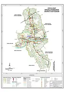
| Website | Official Map of Rangunia |
Geography
Rangunia Upazila is located in between 22°18' and 22°37' north latitudes and in between 91°58' and 92°08' east longitudes. It has 46,176 households and a total area of 347.72 km2.
It is bounded by Chandanaish Upazila on the south; Patiya Upazila, Boalkhali Upazila, Raozan Upazila & Kawkhali Upazila of Rangamati District on the west; Kawkhali Upazila of Rangamati District on the north and Kaptai Upazila & Rajasthali Upazila of Rangamati District and Bandarban Sadar Upazila on the east. Rangunia is the administrative headquarter of this upazila.
Main river: Karnaphuli, Ichamoti.
Population
According to the 2011 Bangladesh census, total population of Rangunia Upazila was 340000; male 169596, female 170404; Muslim 78%, Hindu 15%, Buddhist 6% and others 1%. Indigenous communities such as chakma and marma belong to this upazila. Total Voter 240915; male 124363 & female 116552.[1]
History
Chakma kings (Shukdev Roy, Sher Daulat Khan, Jan Baksh Khan, Tabbar Khan, Jabbar Khan, Dharam Baksh Khan, Rani Kalindi, Harish Chandra Rai and others) ruled this area since 1757. Chakma King Harish Chandra transferred his capital from Rajanagar of Rangunia to Rangamati in 1874.
Points of interest
Tourists spots
- Sheikh Russel Aviary Park
- Rahmania Islamic Complex
- Baitul Musharraf Shahi Jame Masjid
- Remnants of the Chakma Rajbari (Shukbilash, Padua)
- Mahamuni Buddhist Monastery
- Tea garden (Agunia, Kodala, Thandachhari).
Archaeological heritage & relics
- Rahmania Islamic Complex
- Baitul Musharraf Shahi Jame Masjid
- Pagla Mama Dargah (19th century)
Administration
Rangunia Thana was formed on 24 January 1962 and it was turned into an upazila in 1983. Municipality was formed on 4 July 2000.
Rangunia Upazila is divided into Rangunia Municipality and 15 union parishads: Betagi, Chandraghona, Dakshin Rajanagar, Hosnabad, Islampur, Kodala, Lalanagar, Mariumnagar, Padua, Parua, Pomara, Rajanagar, Rangunia, Sharafbhata, and Silak. The union parishads are subdivided into 73 mauzas and 138 villages.[2]
Rangunia Municipality is subdivided into 9 wards and 22 mahallas.[2]
- Perliamentery Area: 284 Chittagong-7 (including Shreepur-Kharandweep Union of Boalkhali Upazila)
- Member of Perliament: D. Hasan Mahmud
- Municipality chairman: Shahjahan Shikdar
- Upazila Chairman:Kalil Ahmed Sikder
- Vice Chairman: Aktar Hossain (Independent)
- Woman Vice Chairman: Rehena Begum
- Upazila Nirbahi Officer (UNO): Mohammad Masudur Rahman
Infrastructure
Communication Facilities
- Chittagong-Rangamati Highway
- Chittagong-Kaptai Highway
- Chandraghona-Bandarban Highway
- Mariamnagar-Ranirhat Link Road
- Rowazarhat-Ranirhat Link Road
- Godown-Padua Link Road
- Godown-Boalkhali Link Road
Health centres
Upazila health complex 1, family planning centre 11, satellite clinic 2.
Religious Institutions
Mosque 359, Temple 42, Tomb 3, Pagoda 41, Sacred place 1.
Education
Rangunia Upazila had an average literacy rate of 70.75%.
There are 9 colleges, 40 secondary schools, 25 madrasas, 179 primary school and many other registered and kindergartens in the upazila.
Colleges
- Rangunia Govt. College
- Rangunia Women College
- North Rangunia Degree College
- Rajanagar Ranirhat Degree College
- Syeda Selima Qader Chowdhury Degree College
- South Rangunia Padua College
- M Shah Alam Chowdhury Degree College
- Hasina Jamal Degree College
- Shilok Balika Mohabidhyaloy
- Rangunia Alamsha Para Alia Madrasha
- Pomra Jameul Ulum Degree Madrasha
According to Banglapedia, Pomara High School, founded in 1928, Rangunia Ideal Multilateral Pilot High School (1915), Rangunia Khilmogal Rashik High School (1926), Rangunia Majumdarkhil High School (1927), and Uttar Rangunia High School (1942) are notable secondary schools.[3]
Economics
Main sources of income are: Agriculture 39.71%, non-agricultural labourer 4.30%, industry 0.58%, commerce 16.24%, transport and communication 3.57%, service 12.31%, construction 1.03%, religious service 0.49%, rent and remittance 10.91% and others 10.86%.
Newspapers & periodicals
- Ranguniar Khobor (weekly)
- Rupali Rangunia
- Ashar Alo
- Rangunia Sangbad
- Rangunianews24.com
In War of Liberation
In 1971, encounters were held between the freedom fighters and the Pak army at Ranirhat, Rowajarhat and Rangunia. The Pak army conducted looting, burning, rape and mass killing in various places of the upazila.
- Marks of the War of Liberation
- Mass Grave - 2
- Memorial Monument - 3 (Rangunia College, Rangunia Ideal Multilateral Pilot High School and Ichakhali).
References
- Bangladesh Population Census 2001, Bangladesh Bureau of Statistics; Cultural survey report of Rangunia Upazila 2007
- "District Statistics 2011: Chittagong" (PDF). Bangladesh Bureau of Statistics. Archived from the original (PDF) on 13 November 2014. Retrieved 14 July 2014.
- Barua, Suniti Ranjan (2012). "Rangunia Upazila". In Islam, Sirajul; Jamal, Ahmed A. (eds.). Banglapedia: National Encyclopedia of Bangladesh (Second ed.). Asiatic Society of Bangladesh.
