Thanchi Upazila
Thanchi (Bengali: থানচি) is an upazila of Bandarban District in the Division of Chittagong, Bangladesh.[1]
Thanchi
থানচি | |
|---|---|
 Thanchi Location in Bangladesh | |
| Coordinates: 21°47.2′N 92°25.7′E | |
| Country | |
| Division | Chittagong Division |
| District | Bandarban District |
| Area | |
| • Total | 1,020.82 km2 (394.14 sq mi) |
| Population (1991) | |
| • Total | 16,104 |
| • Density | 16/km2 (41/sq mi) |
| Time zone | UTC+6 (BST) |
| Website | Official Map of Thanchi |
Geography
Thanchi is located at 21.7861°N 92.4278°E. It has 2,885 households and a total area of 1020.82 km2.
Demographics
According to the 1991 Bangladesh census, Thanchi has a population of 16104. Males constituted 55.61% of the population, and females 44.39%. The population aged 18 or over was 8,639. Thanchi had an average literacy rate of 17.4% (7+ years), against the national average of 32.4%.[2]
Administration
Thanchi Upazila is divided into four union parishads: Balipara, Remakry, Thanchi, and Tindu. The union parishads are subdivided into 12 mauzas and 178 villages.[3]
Gallery
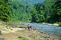 Remakri lake
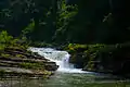 Amiakhum waterfall
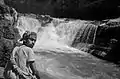 Nafakhum waterfall
References
- Atikur Rahman (2012). "Thanchi Upazila". In Sirajul Islam and Ahmed A. Jamal (ed.). Banglapedia: National Encyclopedia of Bangladesh (Second ed.). Asiatic Society of Bangladesh.
- "Population Census Wing, BBS". Archived from the original on 2005-03-27. Retrieved November 10, 2006.
- "District Statistics 2011: Bandarban" (PDF). Bangladesh Bureau of Statistics. Archived from the original (PDF) on 13 November 2014. Retrieved 14 July 2014.
External links
| Upazila/Thana: | ||
|---|---|---|

This article is issued from Wikipedia. The text is licensed under Creative Commons - Attribution - Sharealike. Additional terms may apply for the media files.