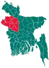
Sapahar Upazila
Sapahar (Bengali: সাপাহার) is an Upazila of Naogaon District[1] in the Division of Rajshahi, Bangladesh.
Sapahar Upazila
সাপাহার | |
|---|---|
 Sapahar Upazila Location in Bangladesh | |
| Coordinates: 25°7.5′N 88°34.9′E | |
| Country | |
| Division | Rajshahi Division |
| District | Naogaon District |
| Government | |
| • Chairman | Shahjahan Mandal |
| Area | |
| • Upazila | 244.49 km2 (94.40 sq mi) |
| • Metro | 8.3 km2 (3.2 sq mi) |
| Population (2011 census) | |
| • Upazila | 161,791 |
| • Density | 660/km2 (1,700/sq mi) |
| Time zone | UTC+6 (BST) |
| Postal code | 6560 |
| Website | Official Map of Sapahar |
Geography
_Bangladesh.svg.png.webp)
Sapahar is located at 25.1250°N 88.5819°E. It has 19,770 house holds and total area 244.49 km2.
Sapahar Upazila is bounded by Tapan CD Block in Dakshin Dinajpur district, West Bengal, India, on the north, Patnitala Upazila on the east, Porsha Upazila on the south, and Bamangola CD Block, in Malda district, West Bengal, on the west.[2][3][4] Main river is "Punarbhaba" at Patari village and Jabai Beel is notable.
Town profile
Sapahar Sadar Town covers an area of 8.3 km2 (3.2 sq mi). The town area consists of ward no. 1, 2, 4 and partially 3. According to the census of 2011, It has a population of 12696. About 2924 households are situated here. Previously this place was known as a hat. In 1979, a Police Station was set up here. Later in 1985 it was turned into a upazila. This town is very famous for its huge improvement in education sector. Many educational institutions can be found here, including one govt. college and one govt. girls' high school. It has 9 kindergartens, 5 high schools, 4 madrashas, 3 colleges and 2 Technical institutions. Besides there are many IT institutions, clubs and recreation centers. It is also a very popular destination for shopping and other business. Many large markets and business centers are installed here. Several banking systems are also available here. All kinds of modern facilities are provided here so its population is increasing day by day.
Demographics
According to 2011 Bangladesh census, Sapahar had a population of 161,792. Males constituted 50.25% of the population and females 49.75%. Muslims formed 93.26% of the population, Hindus 4.87%, Christians 0.46% and others 1.42%. Sapahar had a literacy rate of 42.19% for the population 7 years and above.[5]
Most of the population sepak Bengali.Bengali people formed 98.13% of the population. Other 1.87 of the population speak some tribal language; such as Santali, Sadri, Munda , Mahali etc.
Art and culture
- Sapahar Dance Academy
- Sapahar Comedy Club
Economy
Most of the people of the Sapahar Upazila depends on the agriculture. Agriculture plays a great role on the people of sapahar upazila. Land use: Total cultivable land 25162 hectares, fallow land 100 hectares; single crop 62%, double crop 29% and treble crop land 9
Main crops are Mango, paddy, wheat, fish and vegetables. Sapahar is widely known for Mango production and mango export.
Points of interest
- Jobay Beel
Administration
Sapahar Upazila is divided into six union parishads: Aihai, Goala, Pathari, Sapahar, Shiranti, and Tilna. The union parishads are subdivided into 151 mauzas and 232 villages.[6]
Education
government college 1, non-government college 5, government high school 1, non-government high school 30, government primary school 53, non-government primary school 49, community school 6, satellite school 12, madrasa 46, Computer Training Center 3.
The names of popular educational institutes of Sapahar include:
- Sapahar Government College
- Chowdhury Chan Mohammad Women College
- Bhioil Degree College
- Tilna Degree College
- Dighirhat Degree College
- Sapahar Technical And Business Management College
High schools
- Al-Helal Islami Academy & College, Sapahar, Naogaon
- Sapahar Pilot High School, Naogaon
- Sapahar Govt. Girls High School
- Zaman Nagor Girls HighSchool
- Dangapara High School
- Shironty Moinakuri High School
- Tilna ML High School
- Jobay High School
- Aihai High School
- Tiloni-Patari High School
- Mirapara High School
- Bhioil High School
- Kalmudanga High School
- Goala High School
- Nischinta Pur High School
- Khottapara High School
- koch kurulia High School
- TEGHORIA B.L HIGH SCHOOL
- Tatoir Bakharpur High School
- Asharanda High School
- Chackgopal High School
Primary/KG
- Al-Helal Islami Academy & College, Sapahar, Naogaon
- Sapahar Biddyaniketon (KG School)
- Sapahar Govt. Model Primary School
- Oxford Kindergarten
- Islamic International School
- Joypur Rajjyodhar Govt. Primary School, Sapahar
- Sristy Academy, Sapahar
- Nucleus Pre-Cadet Academy, Sapahar
- Tengrakuri Primary School
- Mahajidpara Govt. Primary School
- MANIKURA Govt Primary School
- Jobay Govt. Primary School
- Tilna Govt. PrimarySchool
- Ashranda Govt. Primary School
- Aihai Govt. Primary School.
- Kherunda Govt. Primary School
- Tatoir Govt Primary School, Tatoir
- Kuchindari Govt.Primary School
- Chackgopal Govt. Primary School*
Madrashas
- Sapahar Sharaftullah Madrasha
- Sapahar Sahanabi Qaomi Madrasha
- Sapahar Mahila Madrasha
- Chanchahar Fazil Madrasha
- Patari Fazil Madrasha
- Mohajid Para Dakhil Madrasa
- Baikanthapur Tiloni Dakhil Madrasha
- Jobay Sufia Senior Fazil Madrasha
- Mungroil Fazil Madrasha
- Gopalpur Fazil Madrasha
- Aladipur Madrasha
- Islampur Dakhil Madrasha
- Tatoir Bakharpur Mohila Dhakil Madrasah
- Shahabajpur M.U.Alim madrasha
- Pahari Pukur Dalhil Madrasha
- Malipur Manikpir Dakhil Madrasha
- Hapania K.M.Fazil Madrasha
Computer Training Center
- Sapahar IT Point.
- Bondhu computer training institute.*
- Ananda Computer Institute
- Sapahar vocational training institute
Gallery
 জিরো পয়েন্ট
 হাসপাতাল রোড
 Public Library
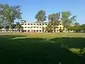 Academic Building
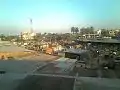 Town area
 Jobay Bridge
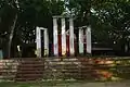 Upazila Chattar Shaheed Minar
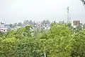 Sapahar Town
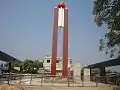 Central Liberation War Monument
References
- Md. Mukhlesur Rahman (2012). "Sapahar Upazila". In Sirajul Islam and Ahmed A. Jamal (ed.). Banglapedia: National Encyclopedia of Bangladesh (Second ed.). Asiatic Society of Bangladesh.
- "Sapahar Upazila". Banglapedia. Retrieved 15 November 2018.
- "Tehsil Map of Dakshin Dinajpur". CD Block/ Tehsil. Maps of India. Retrieved 15 November 2018.
- "Tehsil Map of Maldah". CD Block/ Tehsil. Maps of India. Retrieved 15 November 2018.
- "Bangladesh Population and Housing Census 2011: Zila Report – Nagaon" (PDF). Table P01 : Household and Population by Sex and Residence, Table P05 : Population by Religion, Age group and Residence, Table P09 : Literacy of Population 7 Years & Above by Religion, Sex and Residence. Bangladesh Bureau of Statistics (BBS), Ministry of Planning, Government of the People’s Republic of Bangladesh. Retrieved 9 December 2018.
- "District Statistics 2011: Naogaon" (PDF). Bangladesh Bureau of Statistics. Archived from the original (PDF) on 13 November 2014. Retrieved 14 July 2014.
Capital: Naogaon | ||
| Upazilas | ||
| Constituencies | ||
| Attractions and sites | ||
| History | ||
| Inhabited areas | ||
| Rivers and transport | ||
| Educational institutions |
| |