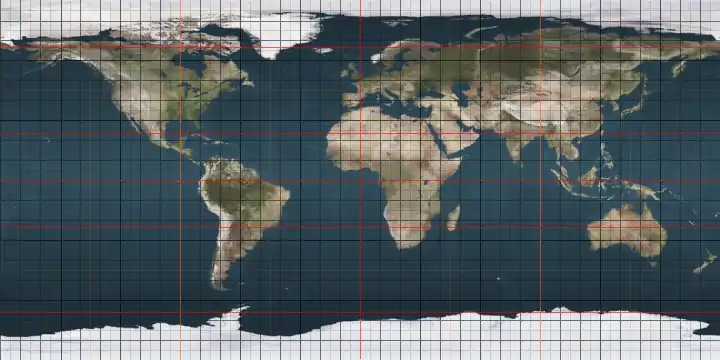
12th parallel south

The 12th parallel south is a circle of latitude that is 12 degrees south of the Earth's equatorial plane. It crosses the Atlantic Ocean, Africa, the Indian Ocean, Australasia, the Pacific Ocean and South America.

12°
12th parallel south

Around the world

Starting at the Prime Meridian and heading eastwards, the parallel 12° south passes through:

Co-ordinates Country, territory or sea Notes
12°0′S 0°0′E Atlantic Ocean
12°0′S 13°43′E  Angola
12°0′S 23°59′E  Zambia
12°0′S 26°42′E  Democratic Republic of the Congo For about 3 km (1.9 mi)
12°0′S 26°43′E  Zambia
12°0′S 27°28′E  Democratic Republic of the Congo
12°0′S 28°45′E  Zambia
12°0′S 33°18′E  Malawi
12°0′S 34°4′E Lake Malawi Passing just north of Chizumulu Island and Likoma Island,  Malawi
12°0′S 34°53′E  Mozambique
12°0′S 40°32′E Indian Ocean Mozambique Channel
- Passing just south of Grande Comore island,  Comoros
- Passing just north of Anjouan island,  Comoros
12°0′S 49°12′E  Madagascar
12°0′S 49°18′E Indian Ocean Passing between North Keeling Island and Horsburgh Island,  Cocos (Keeling) Islands
Passing just north of the Ashmore and Cartier Islands and Hibernia Reef,  Australia
12°0′S 124°22′E Timor Sea Passing south of Bathurst Island,  Australia
Passing through the Clarence Strait
- between Melville Island and the mainland,  Australia
Passing through Van Diemen Gulf
12°0′S 132°37′E  Australia Arnhem Land, Northern Territory
12°0′S 134°17′E Arafura Sea Bocaut Bay
12°0′S 134°40′E  Australia Arnhem Land, Northern Territory
12°0′S 134°45′E Arafura Sea Castlereagh Bay - passing just south of Mooroongga Island,  Australia
12°0′S 135°34′E  Australia Elcho Island and Arnhem Land (mainland), Northern Territory
12°0′S 135°49′E Arafura Sea
12°0′S 136°16′E  Australia Inglis Island and Arnhem Land (mainland), Northern Territory
12°0′S 136°31′E Gulf of Carpentaria
12°0′S 141°50′E  Australia Cape York Peninsula, Queensland
12°0′S 143°11′E Coral Sea Passing just south of Vanatinai island,  Papua New Guinea
Passing just south of Rennell Island,  Solomon Islands
Passing just south of Vanikoro island,  Solomon Islands
12°0′S 167°37′E Pacific Ocean Passing just north of Tikopia island,  Solomon Islands
12°0′S 77°8′W  Peru Passing just north of Lima
12°0′S 68°55′W  Bolivia
12°0′S 65°0′W  Brazil Rondônia
Mato Grosso
Tocantins
Bahia
12°0′S 37°37′W Atlantic Ocean

See also

This article is issued from Wikipedia. The text is licensed under Creative Commons - Attribution - Sharealike. Additional terms may apply for the media files.