City Hall station (IRT Lexington Avenue Line)
City Hall, also known as City Hall Loop, was a terminal station on the IRT Lexington Avenue Line of the New York City Subway. It was under City Hall Park next to New York City Hall in Civic Center, Manhattan.
City Hall | |||||||||||||||||||||||||||||||||||||||||||||||||||||||||||||||||||||||||||||||||||||||||||||||||||||||||||||||||||||||||||||||||||||||||||||||||||||||||||||||||||||||||||||||||||||||||||||||||||||||||||||||||||||||||||||||||||||
|---|---|---|---|---|---|---|---|---|---|---|---|---|---|---|---|---|---|---|---|---|---|---|---|---|---|---|---|---|---|---|---|---|---|---|---|---|---|---|---|---|---|---|---|---|---|---|---|---|---|---|---|---|---|---|---|---|---|---|---|---|---|---|---|---|---|---|---|---|---|---|---|---|---|---|---|---|---|---|---|---|---|---|---|---|---|---|---|---|---|---|---|---|---|---|---|---|---|---|---|---|---|---|---|---|---|---|---|---|---|---|---|---|---|---|---|---|---|---|---|---|---|---|---|---|---|---|---|---|---|---|---|---|---|---|---|---|---|---|---|---|---|---|---|---|---|---|---|---|---|---|---|---|---|---|---|---|---|---|---|---|---|---|---|---|---|---|---|---|---|---|---|---|---|---|---|---|---|---|---|---|---|---|---|---|---|---|---|---|---|---|---|---|---|---|---|---|---|---|---|---|---|---|---|---|---|---|---|---|---|---|---|---|---|---|---|---|---|---|---|---|---|---|---|---|---|---|---|---|---|
| Former New York City Subway station | |||||||||||||||||||||||||||||||||||||||||||||||||||||||||||||||||||||||||||||||||||||||||||||||||||||||||||||||||||||||||||||||||||||||||||||||||||||||||||||||||||||||||||||||||||||||||||||||||||||||||||||||||||||||||||||||||||||
.jpg.webp) Seen in 2018 | |||||||||||||||||||||||||||||||||||||||||||||||||||||||||||||||||||||||||||||||||||||||||||||||||||||||||||||||||||||||||||||||||||||||||||||||||||||||||||||||||||||||||||||||||||||||||||||||||||||||||||||||||||||||||||||||||||||
| Station statistics | |||||||||||||||||||||||||||||||||||||||||||||||||||||||||||||||||||||||||||||||||||||||||||||||||||||||||||||||||||||||||||||||||||||||||||||||||||||||||||||||||||||||||||||||||||||||||||||||||||||||||||||||||||||||||||||||||||||
| Address | Park Row & City Hall Park New York, NY 10007[1][2]:1 | ||||||||||||||||||||||||||||||||||||||||||||||||||||||||||||||||||||||||||||||||||||||||||||||||||||||||||||||||||||||||||||||||||||||||||||||||||||||||||||||||||||||||||||||||||||||||||||||||||||||||||||||||||||||||||||||||||||
| Borough | Manhattan | ||||||||||||||||||||||||||||||||||||||||||||||||||||||||||||||||||||||||||||||||||||||||||||||||||||||||||||||||||||||||||||||||||||||||||||||||||||||||||||||||||||||||||||||||||||||||||||||||||||||||||||||||||||||||||||||||||||
| Locale | Civic Center | ||||||||||||||||||||||||||||||||||||||||||||||||||||||||||||||||||||||||||||||||||||||||||||||||||||||||||||||||||||||||||||||||||||||||||||||||||||||||||||||||||||||||||||||||||||||||||||||||||||||||||||||||||||||||||||||||||||
| Division | A (IRT) | ||||||||||||||||||||||||||||||||||||||||||||||||||||||||||||||||||||||||||||||||||||||||||||||||||||||||||||||||||||||||||||||||||||||||||||||||||||||||||||||||||||||||||||||||||||||||||||||||||||||||||||||||||||||||||||||||||||
| Line | IRT Lexington Avenue Line | ||||||||||||||||||||||||||||||||||||||||||||||||||||||||||||||||||||||||||||||||||||||||||||||||||||||||||||||||||||||||||||||||||||||||||||||||||||||||||||||||||||||||||||||||||||||||||||||||||||||||||||||||||||||||||||||||||||
| Services | None (abandoned) | ||||||||||||||||||||||||||||||||||||||||||||||||||||||||||||||||||||||||||||||||||||||||||||||||||||||||||||||||||||||||||||||||||||||||||||||||||||||||||||||||||||||||||||||||||||||||||||||||||||||||||||||||||||||||||||||||||||
| Structure | Underground | ||||||||||||||||||||||||||||||||||||||||||||||||||||||||||||||||||||||||||||||||||||||||||||||||||||||||||||||||||||||||||||||||||||||||||||||||||||||||||||||||||||||||||||||||||||||||||||||||||||||||||||||||||||||||||||||||||||
| Platforms | 1 side platform | ||||||||||||||||||||||||||||||||||||||||||||||||||||||||||||||||||||||||||||||||||||||||||||||||||||||||||||||||||||||||||||||||||||||||||||||||||||||||||||||||||||||||||||||||||||||||||||||||||||||||||||||||||||||||||||||||||||
| Tracks | 1 balloon loop | ||||||||||||||||||||||||||||||||||||||||||||||||||||||||||||||||||||||||||||||||||||||||||||||||||||||||||||||||||||||||||||||||||||||||||||||||||||||||||||||||||||||||||||||||||||||||||||||||||||||||||||||||||||||||||||||||||||
| Other information | |||||||||||||||||||||||||||||||||||||||||||||||||||||||||||||||||||||||||||||||||||||||||||||||||||||||||||||||||||||||||||||||||||||||||||||||||||||||||||||||||||||||||||||||||||||||||||||||||||||||||||||||||||||||||||||||||||||
| Opened | October 27, 1904[3] | ||||||||||||||||||||||||||||||||||||||||||||||||||||||||||||||||||||||||||||||||||||||||||||||||||||||||||||||||||||||||||||||||||||||||||||||||||||||||||||||||||||||||||||||||||||||||||||||||||||||||||||||||||||||||||||||||||||
| Closed | December 31, 1945[4] | ||||||||||||||||||||||||||||||||||||||||||||||||||||||||||||||||||||||||||||||||||||||||||||||||||||||||||||||||||||||||||||||||||||||||||||||||||||||||||||||||||||||||||||||||||||||||||||||||||||||||||||||||||||||||||||||||||||
| Station succession | |||||||||||||||||||||||||||||||||||||||||||||||||||||||||||||||||||||||||||||||||||||||||||||||||||||||||||||||||||||||||||||||||||||||||||||||||||||||||||||||||||||||||||||||||||||||||||||||||||||||||||||||||||||||||||||||||||||
| Next north | Brooklyn Bridge–City Hall | ||||||||||||||||||||||||||||||||||||||||||||||||||||||||||||||||||||||||||||||||||||||||||||||||||||||||||||||||||||||||||||||||||||||||||||||||||||||||||||||||||||||||||||||||||||||||||||||||||||||||||||||||||||||||||||||||||||
| Next south | (Terminal) | ||||||||||||||||||||||||||||||||||||||||||||||||||||||||||||||||||||||||||||||||||||||||||||||||||||||||||||||||||||||||||||||||||||||||||||||||||||||||||||||||||||||||||||||||||||||||||||||||||||||||||||||||||||||||||||||||||||
| |||||||||||||||||||||||||||||||||||||||||||||||||||||||||||||||||||||||||||||||||||||||||||||||||||||||||||||||||||||||||||||||||||||||||||||||||||||||||||||||||||||||||||||||||||||||||||||||||||||||||||||||||||||||||||||||||||||
City Hall Subway Station (IRT) | |||||||||||||||||||||||||||||||||||||||||||||||||||||||||||||||||||||||||||||||||||||||||||||||||||||||||||||||||||||||||||||||||||||||||||||||||||||||||||||||||||||||||||||||||||||||||||||||||||||||||||||||||||||||||||||||||||||
New York City Landmark No. 1096 | |||||||||||||||||||||||||||||||||||||||||||||||||||||||||||||||||||||||||||||||||||||||||||||||||||||||||||||||||||||||||||||||||||||||||||||||||||||||||||||||||||||||||||||||||||||||||||||||||||||||||||||||||||||||||||||||||||||
| Location | New York City, New York | ||||||||||||||||||||||||||||||||||||||||||||||||||||||||||||||||||||||||||||||||||||||||||||||||||||||||||||||||||||||||||||||||||||||||||||||||||||||||||||||||||||||||||||||||||||||||||||||||||||||||||||||||||||||||||||||||||||
| Coordinates | 40°42′48″N 74°00′24″W | ||||||||||||||||||||||||||||||||||||||||||||||||||||||||||||||||||||||||||||||||||||||||||||||||||||||||||||||||||||||||||||||||||||||||||||||||||||||||||||||||||||||||||||||||||||||||||||||||||||||||||||||||||||||||||||||||||||
| Built | 1904 | ||||||||||||||||||||||||||||||||||||||||||||||||||||||||||||||||||||||||||||||||||||||||||||||||||||||||||||||||||||||||||||||||||||||||||||||||||||||||||||||||||||||||||||||||||||||||||||||||||||||||||||||||||||||||||||||||||||
| Architect | Heins & LaFarge | ||||||||||||||||||||||||||||||||||||||||||||||||||||||||||||||||||||||||||||||||||||||||||||||||||||||||||||||||||||||||||||||||||||||||||||||||||||||||||||||||||||||||||||||||||||||||||||||||||||||||||||||||||||||||||||||||||||
| Architectural style | Romanesque Revival | ||||||||||||||||||||||||||||||||||||||||||||||||||||||||||||||||||||||||||||||||||||||||||||||||||||||||||||||||||||||||||||||||||||||||||||||||||||||||||||||||||||||||||||||||||||||||||||||||||||||||||||||||||||||||||||||||||||
| MPS | New York City Subway System MPS | ||||||||||||||||||||||||||||||||||||||||||||||||||||||||||||||||||||||||||||||||||||||||||||||||||||||||||||||||||||||||||||||||||||||||||||||||||||||||||||||||||||||||||||||||||||||||||||||||||||||||||||||||||||||||||||||||||||
| NRHP reference No. | 04001010[2] | ||||||||||||||||||||||||||||||||||||||||||||||||||||||||||||||||||||||||||||||||||||||||||||||||||||||||||||||||||||||||||||||||||||||||||||||||||||||||||||||||||||||||||||||||||||||||||||||||||||||||||||||||||||||||||||||||||||
| NYCL No. | 1096 | ||||||||||||||||||||||||||||||||||||||||||||||||||||||||||||||||||||||||||||||||||||||||||||||||||||||||||||||||||||||||||||||||||||||||||||||||||||||||||||||||||||||||||||||||||||||||||||||||||||||||||||||||||||||||||||||||||||
| Significant dates | |||||||||||||||||||||||||||||||||||||||||||||||||||||||||||||||||||||||||||||||||||||||||||||||||||||||||||||||||||||||||||||||||||||||||||||||||||||||||||||||||||||||||||||||||||||||||||||||||||||||||||||||||||||||||||||||||||||
| Added to NRHP | September 17, 2004 | ||||||||||||||||||||||||||||||||||||||||||||||||||||||||||||||||||||||||||||||||||||||||||||||||||||||||||||||||||||||||||||||||||||||||||||||||||||||||||||||||||||||||||||||||||||||||||||||||||||||||||||||||||||||||||||||||||||
| Designated NYCL | October 23, 1979[5] | ||||||||||||||||||||||||||||||||||||||||||||||||||||||||||||||||||||||||||||||||||||||||||||||||||||||||||||||||||||||||||||||||||||||||||||||||||||||||||||||||||||||||||||||||||||||||||||||||||||||||||||||||||||||||||||||||||||
Built for the Interborough Rapid Transit Company (IRT), the City Hall station was constructed as the southern terminal of the city's first subway line, which was approved in 1900. Construction on the segment of the line that includes the City Hall station started on September 12 of the same year. The station opened on October 27, 1904, as one of the original 28 stations of the New York City Subway. As ridership grew, it was deemed infeasible to lengthen the original 257-foot (78 m) platform to accommodate ten-car trains. The station was closed on December 31, 1945, because of its proximity to the Brooklyn Bridge station.
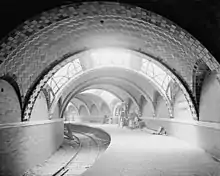
The City Hall station, with its single track and curved side platform, was the showpiece of the original IRT subway. The single platform and mezzanine feature Guastavino tile, skylights, colored glass tilework, and brass chandeliers. The Rafael Guastavino-designed station is unique in the system for the usage of Romanesque Revival architecture. The tunnel passing through the City Hall station is still used as a turning loop for the 6 and <6> trains. The station is a New York City designated landmark and listed on the National Register of Historic Places.
History
Construction and opening
Planning for the city's first subway line dates to the Rapid Transit Act, authorized by the New York State Legislature in 1894.[6]:139–161 The subway plans were drawn up by a team of engineers led by William Barclay Parsons, chief engineer of the Rapid Transit Commission. It called for a subway line from New York City Hall in lower Manhattan to the Upper West Side, where two branches would lead north into the Bronx.[5]:3 A plan was formally adopted in 1897, and legal challenges were resolved near the end of 1899.[6]:139–161 The Rapid Transit Construction Company, organized by John B. McDonald and funded by August Belmont Jr., signed Contract 1 with the Rapid Transit Commission in February 1900,[7] in which it would construct the subway and maintain a 50-year operating lease from the opening of the line.[6]:182 In 1901, the firm of Heins & LaFarge was hired to design the underground stations.[5]:4 Belmont incorporated the Interborough Rapid Transit Company (IRT) in April 1902 to operate the subway.[6]:162–191
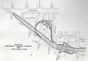
The station had always been envisioned as a terminal with loop tracks. The initial plan called for four tracks on a loop, extending beneath the City Hall Post Office and Courthouse, which was then at the southern corner of City Hall Park. When the plans for the Lexington Avenue Line were changed in 1898 to allow the express tracks to go to Brooklyn as part of the subway's Contract 2, plans were changed so that the station only served local trains, which operated along a single track, to avoid a grade crossing with the express tracks.[5]:5[8]:14 A formal groundbreaking ceremony was performed at City Hall on March 24, 1900, pursuant to the contract's requirements.[6]:162–191[7] The ceremony was officiated by then-Mayor Robert Van Wyck.[9] Degnon-McLean Contracting Company was awarded the contract for Section 1, from the City Hall loop to Chambers Street. Work began promptly after the groundbreaking.[7] A further change was requested in September 1900, which would provide more room for the loop on the Park Row side.[10]
The portion of the loop in City Hall Park began to be excavated in April 1901.[11] The work necessitated relocating several trees from the park using derricks.[12] One worker was killed when a derrick boom in front of the subway excavation was knocked loose.[13] Sand from the 500-foot-long (152 m) excavation was sold to builders who sought it for its "good quality".[14] By August 1901, all of the loop had been excavated within City Hall Park proper.[15] Most of the excavation was covered over shortly afterward, although a small part remained open to facilitate work on the station.[16] The short section adjacent to the post office could not be constructed because the Treasury Secretary had not approved the work, leading the IRT to request approval from Congress.[17][18] With the permanent grant not having been given by late 1901, the contractors began excavating the section under Park Row, carrying both the northbound track of the loop and the express tracks to Brooklyn. This was because the City Hall station's vaults needed to be poured in concrete, which was difficult to pour during winter.[19] The contractors were given temporary permission to use the vaults underneath the post office, and accordingly were able to excavate that section of the loop in 1902.[20]
The City Hall station opened on October 27, 1904, as the southern terminal station of the original 28-station New York City Subway line to 145th Street on the West Side Branch, now the Broadway–Seventh Avenue Line.[6]:162–191[3] The opening ceremonies, held the day before, were attended by Mayor George B. McClellan Jr..[3] More than 15,000 people were issued passes for the first series of rides from the platform. At precisely 2:35 pm, the first subway train departed from City Hall station with Mayor McClellan at the controls. The event was so heavily attended that police Commissioner McAdoo said every policeman in the city was on duty all day and far into the night.[21] At the time of the opening, President A. E. Orr of the Rapid Transit Board requested that all New Yorkers join in the celebration by blowing whistles and ringing bells.[22] The limited entrance and exit facilities necessarily meant that the City Hall station would be a local station, supplementing the nearby Brooklyn Bridge station.[23]
Operation

When the subway opened, the station was called "City Hall Loop".[24] In the first year of operation, East Side local trains to Lenox Avenue (145th Street) ran to City Hall during the daytime, while West Side trains to 157th Street served City Hall during late nights.[25] Afterward, West Side trains to 242nd Street only ran to City Hall during rush hours and East Side trains ran to City Hall at all times. Express trains, and off-peak West Side local trains bypassed this station.[26] In 1918, the Lexington Avenue Line opened north of Grand Central–42nd Street, thereby dividing the original line into an "H" system. All local trains were sent via the Lexington Avenue Line, running along the Pelham Line in the Bronx.[27] During the station's operation, the IRT started displaying advertisements in the station; this was highly controversial, but was allowed under the IRT's contract to operate the route.[13]
Increased subway ridership led to longer trains, and thus longer platforms, in the years after the subway's construction.[28] The City Hall station, built on a tight curve, would have been difficult to lengthen, and it was also quite close to the far busier Brooklyn Bridge–City Hall station.[29] In addition, the new, longer trains had center doors in each car, which were an unsafe distance from the platform edge. Movable platform extensions were installed to fill the gap.[2]:5 By the 1930s, the New York Herald Tribune reported that the City Hall station was little used, "and many of the younger generation have never seen it".[30] During World War II, shortly before the station's closure, the skylights were blacked out with tar for safety.[2]:4
In its final years, the City Hall station was not open at night, when trains continued to South Ferry. The Brooklyn Bridge station, only about 600 feet (180 m) away, provided both local and express service, including trains to Brooklyn.[2]:8[31] The Brooklyn Bridge streetcar terminal and Park Row station on the BMT elevated lines were above for easy transfers.[28] Given the extensive renovations that would have been required to bring the station up to modern standards, and the fact that the city wanted to improve City Hall Park by removing the entrance kiosks,[31] the city decided to close it instead. The final day of service was December 31, 1945.[28][4] The station recorded 255,000 entries in its final year, compared to the Brooklyn Bridge station, which had 14 million entries.[13] This amounted to about 800 entries per day.[31]
Post-closure
The New York Transit Museum considered the City Hall station as a possible location in 1965.[32] The museum ultimately decided to move to the abandoned Court Street station in Brooklyn.[13] In 1979, the New York City Landmarks Preservation Commission designated the City Hall station as a city landmark, along with eleven other stations on the original IRT.[5][33]
By the 1980s, Mayor Ed Koch suggested allowing a restaurant to open in the old station. As part of the effort to reopen the City Hall station, civic leaders and city officials visited the station in July 1986. Ross Sandler, the city's transportation commissioner and a proponent of the station's reopening, lamented that the station was a "designated landmark that people can't visit".[34] The plan had still not advanced over a year later, when parks commissioner Henry J. Stern said the station's restoration was dependent on whether funding to renovate City Hall Park was secured.[35] Ultimately, the idea was overruled by the New York City Police Department, who expressed concerns about security due to its location below City Hall.[29]
In April 1995, federal grant money was sought to reopen the station as a branch of the New York Transit Museum, which occasionally ran tours of the station. By 1997, some $2 million in state and federal funding had been allocated.[13] Early the next year, MTA officials started refurbishing the station's corridors and offered up to $5 million for underground repairs to City Hall Park, which at the time was being renovated. However, in late 1998, the administration of mayor Rudy Giuliani rejected the proposal, citing security risks in the area around City Hall after terrorist bombings in Nairobi and Dar es Salaam. Plans for the museum annex were abandoned and museum tours ceased for several years.[36]
The station was listed on the National Register of Historic Places in 2004.[2] For the subway's Centennial Celebration the same year, one of the street entrances was restored, and the station was opened for the duration of the celebration. Otherwise, the station is now used only as an emergency exit. By 2006, tours of the station were once again being conducted[37] by the staff of the Transit Museum.[38]
Station layout
| G | - | Street Level |
| P Platform level |
Side platform, not in service | |
| Northbound local | ← | |
The station consists of a concave 257-foot (78 m)-long side platform along a single balloon loop track, which could fit five cars. The radius of curvature of the track is about 150 feet (46 m),[13] meaning that the platform curves approximately 98.2 degrees between its front and back ends.[lower-alpha 1] As a result, when the station was in service, there were significant platform gaps between the train doors and the platform.[5]:6[2]:3 The fare control area was on a mezzanine slightly above platform level, connected to the platform by a single, wide staircase.[5]:6[8]:14[2]:4 Intended as the showpiece of the entire subway system, the City Hall station was designed in a completely different style from the remaining stations on the IRT subway.[5]:5[8]:14
The travel magazine Travel + Leisure ranked the station 12th in its list of "the most beautiful subway stations in the world" in November 2009.[39][40] A replica of the station was built for the feature film Fantastic Beasts And Where To Find Them. In addition, the station is said to be the model for the lair of Teenage Mutant Ninja Turtles.[29]
Design
.jpg.webp)
.jpg.webp)
The station was designed by Rafael Guastavino, and makes extensive use of classic Guastavino tile to sheathe its soaring roof arches.[41] The main consulting architects were Heins & LaFarge, which designed all of the other IRT stations.[2]:7 This station is unusually elegant in architectural style, and is unique among the original IRT stations, employing Romanesque Revival architecture.[42] The station was constructed by cut-and-cover construction. The bottom of the station shell contains a foundation of concrete no less than 4 inches (100 mm) thick.[2]:3 There is a 1-inch (25 mm) gap between the trough wall and the station walls, which are made of 4-inch (100 mm)-thick brick covered over by a tiled finish.[2]:3
The ceiling is made of twelve Guastavino vaults. The ceiling surfaces are composed of white tiles, with green and brown tiles along the perimeter of each ceiling vault.[5]:6[8]:15[2]:4 The vaults were constructed of thin terracotta tiles bonded with a string mortar, added in successive layers to form a thin structural vault of great strength. Three vaults had leaded glass skylights, which opened upward to vault lights in City Hall Park.[8]:14–15 The skylights, designed with floral tracery,[30] were blacked out during World War II and were restored in the 2000s.[2]:4 Additional lighting was supplied by twelve chandeliers hung from the center of the vaults, which contain floral motifs and nickel finishes. The chandeliers near the skylights have five arms, while the others have four.[8]:15[2]:4
a.jpg.webp)
The platform is made of poured concrete.[5]:6[2]:3 The platforms still contain markings from where the platform extensions were formerly installed.[2]:5 The top half of the wall along the platform, under each of the arches, consists of Roman brick. At the bottom half of each wall is a marble course topped by a brick wainscoting and another marble course.[8]:14[2]:4 On the platform walls are three blue-on-white faience plaques with letters reading city hall, flanked by a pair of triangles and surrounded by green and buff tiles. Two of these plaques are rectangular, installed on the walls under the brick arches, while a third is curved and is installed above the staircase leading to the mezzanine.[5]:6[2]:4–5[8]:15 On the trackside wall, facing the platform, are three bronze plaques with the names of important figures involved in the original IRT's construction, including Parsons, McDonald, Belmont, Rapid Transit Subway Construction Company officials, engineering staff, mayors, commissioners, and city comptrollers. Gutzon Borglum designed the plaques.[29][2]:5[30]
The mezzanine contains a vaulted ceiling with a "quoin" pattern, consisting of brown trim with white and green tiles. The center of the mezzanine has a oculus skylight, with light bulbs around the skylight. The walls of the mezzanine contain large glass tiles interspersed with opaque ceramic tile. Wire conduits and pipes have been installed onto the mezzanine walls.[2]:3–4 The mezzanine once had an ornamented oak ticket booth, which has since been removed.[43]
Track layout
North of the City Hall station, the IRT Lexington Avenue Line carries four tracks. From west to east, these are the downtown local track, the downtown express track, the uptown express track, and the uptown local track.[44]
South of the Brooklyn Bridge station, there is a switch on the downtown local track, allowing trains to leave service and enter either of two storage tracks. Trains in service turn onto a balloon loop, continuing past the abandoned side platform on the west side of the loop, and re-appearing in the Brooklyn Bridge station on the uptown local track. The uptown and downtown express tracks pass above the loop, continuing south.[44]
Exits and access

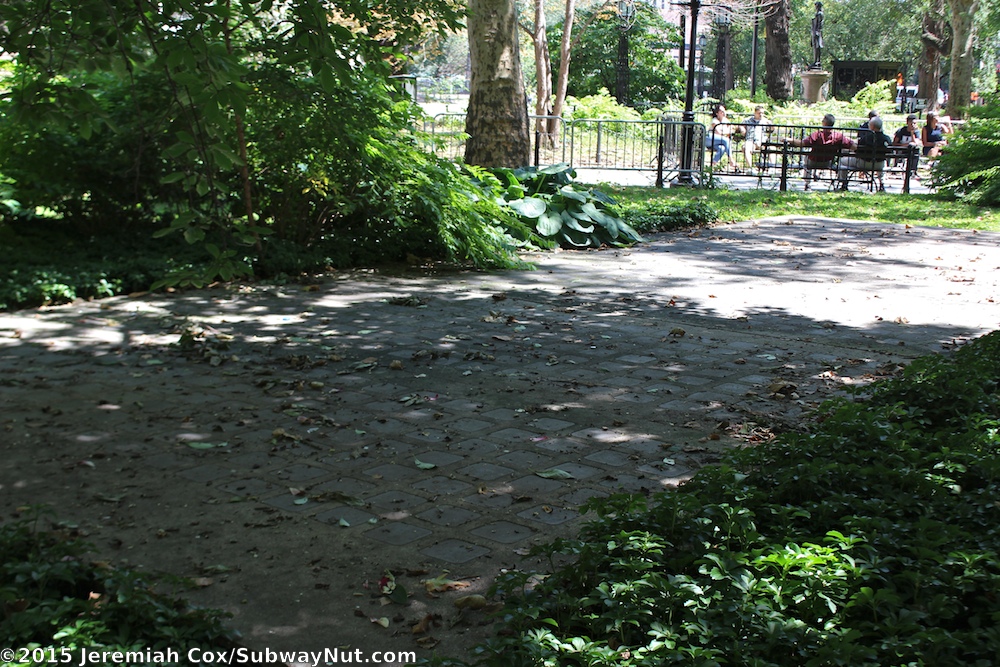
There were two staircases from outside the City Hall building to the mezzanine of the station; they have been slabbed over.[2]:4 On the surface, all that can be seen is a concrete slab inset with glass tiles, the skylights for the platform below. This patch of concrete is in the middle of a grove of dogwoods in front of City Hall, close to Broadway. At street level, in the pavement in front of City Hall, a plaque commemorates the groundbreaking for the subway in 1900.[45]
The station can also be viewed by passengers who stay on the 6 and <6> services as they travel around the loop to head back uptown. Artificial lighting has often been dim to save electricity, but the skylights provide some illumination during the daytime. The loop track is classified as revenue track, and the announcement programs on the R142A subway cars, which were formerly used on the 6 and <6> services, announce a special message reminding passengers that trains would turn around via the loop station.[46] The older R62As, which make up the entire 6 and <6> services' fleet as of 2018, use manual announcements.[47]
See also
- List of closed New York City Subway stations
- Ghost station
- Beach Pneumatic Transit in the basement of the Rogers Peet Building
Notes
- The 150-foot (46 m) radius indicates that a full circle of that radius would have a circumference of 942.478 feet. The platform is 257 feet (78 m) long. The proportion of the platform's length to the full circle indicates that the arc is 98.167 degrees.
References
- "Borough of Manhattan, New York City". Government of New York City. Retrieved December 28, 2020.
- "New York MPS City Hall Subway Station (IRT)". Records of the National Park Service, 1785 - 2006, Series: National Register of Historic Places and National Historic Landmarks Program Records, 2013 - 2017, Box: National Register of Historic Places and National Historic Landmarks Program Records: New York, ID: 75313897. National Archives.
- "Our Subway Open: 150,000 Try It; Mayor McClellan Runs the First Official Train". The New York Times. October 28, 1904. p. 1. ISSN 0362-4331. Retrieved April 21, 2020.
- "Historic Station Closed After 41 Years". The New York Times. January 1, 1946. ISSN 0362-4331. Retrieved May 30, 2010.
- "Interborough Rapid Transit System, Underground Interior" (PDF). New York City Landmarks Preservation Commission. October 23, 1979. Retrieved November 19, 2019.
- Walker, James Blaine (1918). Fifty Years of Rapid Transit — 1864 to 1917. New York, N.Y.: Law Printing. Retrieved November 6, 2016.
- Report of the Board of Rapid Transit Railroad Commissioners for the City of New York For The Year Ending December 31, 1904 Accompanied By Reports of the Chief Engineer and of the Auditor. Board of Rapid Transit Railroad Commissioners. 1905. pp. 229–236.
- Framberger, David J. (1978). "Architectural Designs for New York's First Subway" (PDF). Historic American Engineering Record. pp. 1-46 (PDF pp. 367-412). Retrieved December 20, 2020.
 This article incorporates text from this source, which is in the public domain.
 - "Abandoned Stations : City Hall (IRT)". Columbia.edu. December 31, 1903. Retrieved May 13, 2014.
- "The Rapid Transit Work: Change in Loop at the Post Office Proposed. The Forty-second Street Section May Be Changed -- Progress in Other Directions" (PDF). The New York Times. September 16, 1900. p. 7. ISSN 0362-4331. Retrieved January 6, 2021.
- "At Work on City Hall Loop: Operations Begin on the Excavations for the Southern Termini's of the Tunnel Road". New-York Tribune. April 16, 1901. p. 1. Retrieved January 6, 2021 – via newspapers.com
 .
. - "New York's Rapid Transit Tunnel May Be Finished Ahead of Contract Time". Brooklyn Daily Eagle. July 28, 1901. p. 28. Retrieved January 6, 2021 – via newspapers.com .
- Gray, Christopher (April 13, 1997). "Old Subway Stop to Be a Museum". The New York Times. ISSN 0362-4331. Retrieved December 26, 2020.
- "Subway Work Progress: What Has Been Done in the City Hall Park, at the Park Plaza and Other Points". New-York Tribune. January 21, 1901. p. 4. Retrieved January 6, 2021 – via newspapers.com .
- "The Work on the Subway; All of the Digging in the City Hall Park Accomplished" (PDF). The New York Times. August 26, 1901. p. 2. ISSN 0362-4331. Retrieved January 6, 2021.
- "Subway Progress: Construction Completed and the Street Restored at Many Points Along the Route". New-York Tribune. September 22, 1901. p. 28. Retrieved January 6, 2021 – via newspapers.com .
- "Subway City Hall Loop.; Bill to Allow Its Passage Through Post Office Vaults to Be Introduced in Congress" (PDF). The New York Times. August 7, 1901. p. 9. ISSN 0362-4331. Retrieved January 6, 2021.
- "City Hall "Loop" Blocked". New-York Tribune. August 4, 1901. p. 4. Retrieved January 6, 2021 – via newspapers.com .
- "Work on the Subway's Down-town Sections; Excavating Near the Brooklyn Bridge to Begin This Week" (PDF). The New York Times. December 22, 1901. p. 14. ISSN 0362-4331. Retrieved January 6, 2021.
- "Ask Roosevelt for Permanent Rights; Subway Officials Seek President's Influence to Secure Small Portion of Land Under Post Office" (PDF). The New York Times. December 14, 1902. p. 27. ISSN 0362-4331. Retrieved January 6, 2021.
- "Subway Opening to-day With Simple Ceremony; Exercises at One o'Clock; Public to be Admitted at Seven". The New York Times. October 27, 1904. ISSN 0362-4331. Retrieved April 19, 2020.
- "Interesting Facts About Our Subway; Chronology of the Great Underground System". The New York Times. October 28, 1904. ISSN 0362-4331. Retrieved April 19, 2020.
- "Subway Trains in Fall". New-York Tribune. March 22, 1903. pp. 38, 39 – via newspapers.com .
- Map and Profile of Railway (Map). Interborough Rapid Transit Company. 1904. Retrieved September 15, 2008.
- "Subway Trains Running From Bronx to Battery: West Farms and South Ferry Stations Open at Midnight" (PDF). The New York Times. July 10, 1905. p. 1. ISSN 0362-4331. Retrieved January 6, 2021.
- The Merchants' Association of New York Pocket Guide to New York. Merchants' Association of New York. March 1906. pp. 19–26.
- "Open New Subway Lines to Traffic; Called a Triumph — Great H System Put in Operation Marks an Era in Railroad Construction — No Hitch in the Plans — But Public Gropes Blindly to Find the Way in Maze of New Stations — Thousands Go Astray — Leaders in City's Life Hail Accomplishment of Great Task at Meeting at the Astor" (PDF). The New York Times. August 2, 1918. p. 1. Retrieved November 6, 2016.
- Jaffe, Eric (July 18, 2012). "New York's Lovely Abandoned Subway Station". The Atlantic Cities. The Atlantic. Retrieved July 18, 2012.
- Hu, Winnie (April 11, 2019). "Failing New York Subway? Not Always - Once There Were Chandeliers". The New York Times. ISSN 0362-4331. Retrieved April 11, 2019.
- "Art in Subways Goes Unnoticed By the Public: Some of Old Underground Stations Are Decorated With Picturesque Panels Stained Glass Is in One Old City Hall Stop Also Has Illuminated Bronzes". New York Herald Tribune. November 29, 1936. p. A7. Retrieved January 6, 2021 – via ProQuest.
- "Old City Hall Station Of IRT to Close Monday". The New York Times. December 27, 1945. ISSN 0362-4331. Retrieved December 26, 2020.
- Daley, Robert (January 16, 1965). "Elegant but Abandoned IRT City Hall Stop Proposed as Museum". The New York Times. ISSN 0362-4331. Retrieved December 26, 2020.
- "12 IRT Subway Stops Get Landmark Status". The New York Times. October 27, 1979. ISSN 0362-4331. Retrieved December 26, 2020.
- Anderson, Susan Heller; Bird, David (July 25, 1986). "New York Day by Day; Saluting the Mona Lisa of Subway Stations". The New York Times. ISSN 0362-4331. Retrieved December 25, 2020.
- "Follow-up on the News; a Subway Station Fit for a Museum". The New York Times. September 27, 1987. ISSN 0362-4331. Retrieved December 26, 2020.
- Lueck, Thomas J. (October 17, 1999). "Under City Hall, Dreams and Nightmares; Fears That Reopening Station as Museum Might Lure Terrorists". The New York Times. ISSN 0362-4331. Retrieved December 25, 2020.
- "Living for the City". Forgotten NY. Retrieved November 15, 2009.
- New York City Transit Museum programs
- McCulloch, Adam (November 2009). "World's Most Beautiful Subway Stations". Travel + Leisure. Retrieved January 3, 2012.
- "New York City: City Hall". Travel + Leisure. November 2009. Retrieved January 3, 2012.
- Dunlap, David W. (May 1, 2011). "The City's Curves, on Display or Hidden Away". The New York Times. p. 36.
- Brooks, Michael W. (1997). Subway city: riding the trains, reading New York. New Brunswick, New Jersey: Rutgers University Press. p. 66. ISBN 0-8135-2396-6.
- "THE OLD CITY HALL STATION « UNTAPPED NEW YORK". Untapped New York. October 4, 2010. Archived from the original on October 4, 2010. Retrieved April 19, 2020.CS1 maint: unfit URL (link)
- "Tracks of the New York City Subway". Tracks of the New York City Subway. Retrieved October 9, 2015.
- "City Hall Station". The-tech.mit.edu. Retrieved May 13, 2014.
- Cuza, Bobby (March 6, 2007). "See A Glimpse Of NYC History For The Price Of A Subway Ride". NY1. Archived from the original on January 30, 2013. Retrieved November 15, 2009.
- R62/A and R68/A Request for Information
Further reading
External links
| Wikimedia Commons has media related to City Hall (IRT Lexington Avenue Line). |
| External images | |
|---|---|
- nycsubway.org – IRT East Side Line: City Hall
- Abandoned Stations — City Hall (IRT)
- The IRT First Stations — City Hall
- Forgotten NY — Original 28 – NYC's First 28 Subway Stations
- The Abandoned City Hall Subway Stop Now Visible To Tourists (PHOTOS) at The Huffington Post
- Stair landing from Google Maps Street View
| Government buildings |
|  | |||||
|---|---|---|---|---|---|---|---|
| Non-government buildings |
| ||||||
| Other spaces | |||||||
| Education | |||||||
| Transport |
| ||||||
See also: Manhattan Community Board 1 | |||||||
| Lexington Ave. Line |
|
|---|---|
| |
| Topics |  | |
|---|---|---|
| Lists by county |
| |
| Lists by city | ||
| Other lists | ||
| ||