Union Square, Manhattan
Union Square is a historic intersection and surrounding neighborhood in Manhattan, New York City, located where Broadway and the former Bowery Road – now Fourth Avenue[4] – came together in the early 19th century. Its name denotes that "here was the union of the two principal thoroughfares of the island".[5][6] The current Union Square Park is bounded by 14th Street on the south, 17th Street on the north, and Union Square West and Union Square East to the west and east respectively. 17th Street links together Broadway and Park Avenue South on the north end of the park, while Union Square East connects Park Avenue South to Fourth Avenue and the continuation of Broadway on the park's south side. The park is maintained by the New York City Department of Parks and Recreation.
Union Square | |
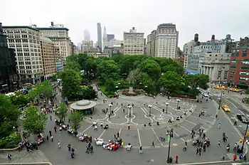 Union Square looking north from 14th Street (May 2010) | |

| |
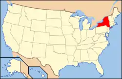
| Location | Manhattan, New York City |
|---|---|
| Coordinates | 40°44′08″N 73°59′26″W |
| Built | 1882 (laid out c. 1832)[1] |
| Architect | Frédéric Auguste Bartholdi, et al. |
| NRHP reference No. | 97001678[2] |
| Significant dates | |
| Added to NRHP | December 9, 1997[2] |
| Designated NHL | December 9, 1997[3] |
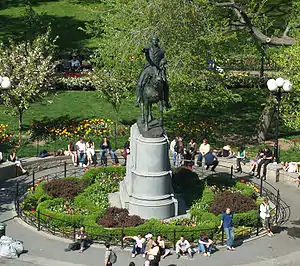
Adjacent neighborhoods are the Flatiron District to the north, Chelsea to the west, Greenwich Village to the southwest, East Village to the southeast, and Gramercy Park to the east. Many buildings of The New School are near the square,[7] as are several dormitories of New York University.[8] The eastern side of the square is dominated by the four Zeckendorf Towers, and the south side by the full-square-block mixed-use One Union Square South, which contains a wall sculpture and digital clock named Metronome. Union Square Park also contains an assortment of art, including statues of George Washington, Marquis de Lafayette, Abraham Lincoln, and Mahatma Gandhi.
Union Square is part of Manhattan Community District 5[9] and its primary ZIP Code is 10003.[10] It is patrolled by the 13th Precinct of the New York City Police Department.[11] The New York City Subway's 14th Street–Union Square station, served by the 4, 5, 6, <6>, L, N, Q, R, and W trains, is located under Union Square.
History
_(NYPL_b13476046-EM11347).jpg.webp)
Development
The area around present-day Union Square was initially farmland. The western part of the site was owned by Elias Brevoort,[5]:221 who later sold his land to John Smith in 1762;[12] by 1788 it had been sold again to Henry Spingler (or Springler).[13][14] On the eastern part of the land were farms owned by John Watts and Cornelius Williams. The northwestern corner of the park site contained 1 acre (0.40 ha) of land owned by the Manhattan Bank, which supposedly was a "refuge" for businesses during New York City's yellow fever epidemics.[5]:222
When John Randel was surveying the island in preparation for the Commissioners' Plan of 1811, the Bloomingdale Road (now Broadway) angled away from the Bowery at an acute angle. Because it would have been difficult to develop buildings upon this angle, the Commissioners decided to form a square at the union.[15] In 1815, by act of the state legislature, this former potter's field became a public commons for the city, at first named Union Place.[5][16] Union Place originally was supposed to extend from 10th to 17th Streets. Several city officials objected that Union Place was too large and requested that it be "discontinued", and in 1814, the New York State Legislature acted to downsize the area by making 14th Street the southern boundary.[17][18][19]:3
In 1831, at a time when the city was quickly expanding and the surrounding area was still sparsely developed, Samuel Ruggles, one of the founders of the Bank of Commerce and the developer of Gramercy Park to the northeast, convinced the city to rename the area as "Union Square". In doing so, Ruggles also got the city to enlarge the commons to 17th Street on the north and extend the axis of University Place to form the square's west side, thus turning the common from a triangular to a rectangular area.[20][19]:5 By 1832, the area had been renamed Union Square.[17][18][21] Ruggles obtained a fifty-year lease on most of the surrounding lots from 15th to 19th Streets, where he built sidewalks and curbs. In 1834, he convinced the Board of Aldermen to enclose and grade the square, then sold most of his leases and in 1839 built a four-story house facing the east side of the Square.[22] The park at Union Square was completed and opened in July 1839.[17]
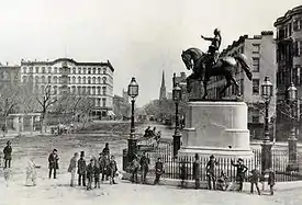
A fountain was built in the center of Union Square to receive water from the Croton Aqueduct, completed in October 1842.[17][23] In 1845, as the square finally began to fill with affluent houses, $116,000 was spent in paving the surrounding streets and planting the square, in part owing to the continued encouragement of Ruggles.[17] The sole survivors of this early phase, though they have been much adapted and rebuilt, are a series of three- and four-story brick rowhouses, 862–866 Broadway, at the turn where Broadway exits the square at 17th Street. The Everett House on the corner of 17th Street and Fourth Avenue (built 1848, demolished 1908) was for decades one of the city's most fashionable hotels.[24]
In the early years of the park a fence surrounded the square's central oval planted with radiating walks lined with trees. In 1872, Frederick Law Olmsted and Calvert Vaux[25] were called in to replant the park, as an open glade with clumps of trees.
At first the square, the last public space that functioned as the entrance to New York City,[26] was largely residential: the Union League Club first occupied a house loaned for the purpose by Henry G. Marquand at the corner of 17th Street and Broadway. After the Civil War the neighborhood became largely commercial, and the square began to lose social cachet at the turn of the twentieth century, with many of the old mansions being demolished.[17] Tiffany & Co., which had moved to the square from Broadway and Broome Street in 1870, left its premises on 15th Street to move uptown to 37th Street in 1905; the silversmiths Gorham Company moved up from 19th Street in 1906. The last of the neighborhood's free-standing private mansions, Peter Goelet's at the northeast corner of 19th Street, made way for a commercial building in 1897.
The Rialto
The Rialto, New York City's first commercial theater district, was located in and around Union Square beginning in the 1870s. It was named after Venice's Rialto, a commercial district.[27][28][29] The first facility to open within the Union Square Rialto was the Academy of Music, which opened at Irving Place in 1854.[6] The theater district gradually relocated northward, into less expensive and undeveloped uptown neighborhoods, and eventually into the current Theater District.[6][27][30]
Before the Civil War, theatres in New York City were primarily located along Broadway and the Bowery up to 14th Street, with those on Broadway appealing more to the middle and upper classes and the Bowery theatres attracting immigrant audiences, clerks and the working class. After the war, the development of the Ladies' Mile shopping district along Fifth and Sixth Avenues above 14th Street had the effect of pulling the playhouses uptown, so that a "Rialto" theatrical strip came about on Broadway between 14th and 23rd Streets, between Union Square and Madison Square.[31][6]
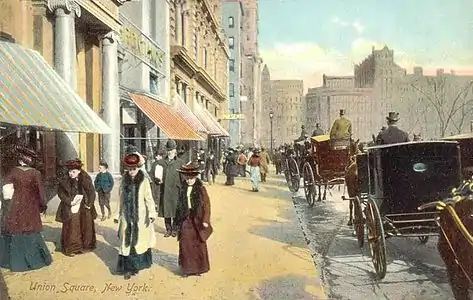
At the same time, a transition from stock companies, in which a resident acting company was based around a star or impresario, to a "combination" system, in which productions were put together on a one-time basis to mount a specific play, expanded the amount of outside support needed to service the theatrical industry. Thus, suppliers of props, costumes, wigs, scenery, and other theatrical necessities grew up around the new theatres. The new system also needed an organized way to engage actors for these one-off productions, so talent brokers and theatrical agents sprang up, as did theatrical boardinghouses, stage photographers, publicity agencies, theatrical printers and play publishers. Along with the hotels and restaurants which serviced the theatregoers and shoppers of the area, the Union Square Rialto was, by the end of the century, a thriving theatrical neighborhood, which would soon nonetheless migrate uptown to what became known as "Broadway" as the Rialto became subsumed into the more vice-oriented Tenderloin entertainment district.[31]
Office and wholesale district
By the first decade of the 20th century, Union Square had grown into a major transportation hub with several elevated and surface railroad lines running nearby, and the New York City Subway's 14th Street–Union Square station having opened in 1904.[32]:2[33] With the northward relocation of the theater district, Union Square also became a major wholesaling district with several loft buildings, as well as numerous office buildings.[34]:2[6] The office structures included the Everett Building, erected at the northwest corner of Park Avenue South and 17th Street in 1908;[35]:4 the Germania Life Insurance Company Building, erected at the northeast corner of the same intersection in 1910–1911;[32]:6 and the Consolidated Edison Building, constructed three blocks south at 14th Street between 1910 and 1914.[36]:5, 8
During this era, many of the older homes on Union Square were converted into tenements for immigrants and industrial workers. Numerous artists relocated into the attics of the remaining mansions along 14th Street, where they had their studios. The 1939 WPA Guide to New York City said that by the 1920s, "south side of Fourteenth Street became virtually an ex-tension of Greenwich Village."[6] Further, real estate values around Union Square had declined by the 1920s, with "burlesque houses, shooting galleries, and shoddy businesses" lining the square.[6] Throughout the decade, most buildings on the eastern part of the square were purchased by department stores S. Klein and Ohrbach's.[34]:2[6] Real estate activity resumed in the late 1920s, and according to a 1928 piece in The New York Times, “several smaller operations are planned or are under way in the neighborhood".[37]
Late 20th and early 21st centuries
Union Square was named a National Historic Landmark in 1997, primarily to honor it as the site of the first Labor Day parade.[3][38][39]
Following the September 11 attacks in 2001, Union Square became a primary public gathering point for mourners. People created spontaneous candle and photograph memorials in the park and vigils were held to honor the victims. At the time, non-emergency vehicles were temporarily banned and pedestrian travel was restricted in Lower Manhattan below 14th Street. The Square's tradition as a meeting place in times of upheaval was also a factor in its being used as a vigil gathering site.

North end renovation
In March 2008, an eighteen-month renovation began on the northern end of the park. Proponents of the plan described it as the completion of a renovation of Union Square Park that began in the mid-1980s that would improve the park by increasing the amount and quality of playground space, improving the quality and function of the public plaza, rehabilitating the badly deteriorating bandshell structure, improving the working conditions for park employees, and maintaining the "eyes on the street" presence of a restaurant at the heart of the park. Protests and political action in response to the original renovation plans resulted in a reduction in the degree to which the pavilion was to be renovated, a reduction in the total amount of space that the restaurant would occupy, and an increase in the amount of dedicated play space, but stiff opposition remains to the idea that any commercial uses might occupy the pavilion. Despite the fact that the overall amount of play space in the park would be increased as a result of the renovation, those critical of the plan claimed that the bandshell pavilion itself ought to be converted to play space.[40][41] The status of the historic pavilion building was later brought before the State Supreme Court.[42][43] In early 2009, a judge dismissed the lawsuit against the renovation, paving the way for a seasonal restaurant in the pavilion.[44]
One element of contention not related to the restaurant concession is the inclusion of a single line of street trees, spaced 30 feet (9.1 m) apart, along the north side of the plaza. The inclusion of trees was made possible without reducing the usable gathering space of the plaza by the simultaneous decision to remove a painted median strip, that had separated eastbound and westbound traffic along 17th Street, thus increasing the northern limits of the plaza by several feet. The "temporary" metal rails, welded together to make a continuous fence along the north side of the site, were removed as part of the renovation of the plaza. A double line of trees along 17th Street had been planted years earlier as a monument to victims of the Armenian Genocide.
During the renovation the Union Square Greenmarket was temporarily relocated to the west side of the park, returning to the north end by April 2009.
Surrounding buildings
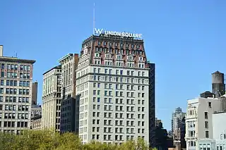
There are several notable buildings surrounding Union Square. Clockwise from southwest, they are:
- Lincoln Building at Union Square West and 14th Street, a city landmark[45] that is also listed on the National Register of Historic Places (NRHP)[2]
- Spingler Building (also Springler Building) at 5–9 Union Square West[46]
- 15 Union Square West (former Tiffany & Co. Building)[47]
- Bank of the Metropolis at 31 Union Square West, a city landmark[48] and a NRHP listing[2]
- Decker Building at 33 Union Square West, a city landmark[49] and a NRHP listing[2]
- Century Building (Barnes & Noble) at 33 East 17th Street, on the north side of Union Square, a city landmark[17] and a NRHP listing[2]
- Everett Building at 45 East 17th Street, on the north side of Union Square, a city landmark[35]
- W New York Union Square (former Germania Life Insurance Company Building) at 50 Union Square East/105 East 17th Street, a city landmark[32] and a NRHP listing[2]
- 44 Union Square East (former Tammany Hall Building), a city landmark[34]
- Daryl Roth Theatre (former Union Square Savings Bank) at 20 Union Square East, a city landmark[50]
- Zeckendorf Towers at 1 Union Square East, a condominium complex on the former site of the bargain-priced department store S. Klein
- One Union Square South (Davis Brody Bond, 1999),[51] features a kinetic wall sculpture and digital clock expelling bursts of steam, titled Metronome.
In addition, the Consolidated Edison Building is located one block east of the Zeckendorf Towers.[36] The Century Association clubhouse is located on 15th Street between Irving Place and Union Square East.[52]
Art and sculpture
Union Square is noted for its impressive equestrian statue of U.S. President George Washington, modeled by Henry Kirke Brown and unveiled in 1856. Located at the south end of the park, it was the first public sculpture erected in New York City since the equestrian statue of George III in 1770, and the first American equestrian sculpture cast in bronze.[53]
The Marquis de Lafayette, at Union Square East and 16th Street, was modeled by Frédéric Auguste Bartholdi and dedicated in 1876, the 100th anniversary of U.S. independence.[54]
The statue of Abraham Lincoln, modeled by Henry Kirke Brown (1870), is located near the north end of the park.[55]
A statue of Mahatma Gandhi in the southwest corner of the park was added in 1986.[56]
The Union Square Drinking Fountain (1881) near Union Square West, also known as the James Fountain, is a Temperance fountain with the figure of Charity who empties her jug of water, aided by a child. It was donated by Daniel Willis James and sculpted by Adolf Donndorf.[57]
The Charles F. Murphy Memorial Flagpole, also known as the Independence Flagstaff, was cast in 1926 and dedicated in 1930 to mark the 150th anniversary of U.S. independence. It is located in the center of the park.[58]
Greenmarkets and businesses
Public markets
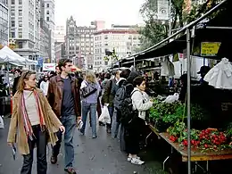
In 1976, the Council on the Environment of New York City (now GrowNYC) established the Greenmarket program, which provided regional small family farmers with opportunities to sell their fruits, vegetables and other farm products at open-air markets in the city. There were originally seven farmers at the first Greenmarket, and their selection sold out by noon.[59] That summer, two more markets opened in New York City. Despite some backlash from local merchants and supermarkets who believed the Greenmarket was cutting into their profits, more markets opened in the city.
Today, the Union Square Greenmarket – the best-known of the markets – is held Mondays, Wednesdays, Fridays, and Saturdays between 8 AM and 6 PM year round. The market is served by a number of regional farmers, as the average distance between farmers and the market is 90 miles (140 km). During peak seasons, the Greenmarket serves more than 250,000 customers per week,[60] who purchase more than one thousand varieties of fruits and vegetables can be found at the Greenmarket;[61] and the variety of produce available is much broader than what is found in a conventional supermarket.[62]
Union Square is also known for the Union Square Holiday Market, which is held November 23 through December 24. Temporary booths are filled with over 100 craftsmen, who sell items ranging from candles and perfume to knitted scarves and high-end jewelry.
Businesses
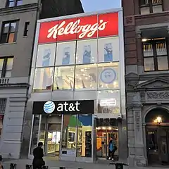
Union Square is a popular meeting place, given its central location in Manhattan and its many nearby subway routes. There are many bars and restaurants on the periphery of the square, and the surrounding streets have some of the city's most renowned (and expensive) restaurants. S. Klein's department store promoted itself in the mid-20th century as an "On the Square" alternative to higher prices uptown,[63] and late in the century several big-box chain stores established a presence, including Barnes & Noble in the Century Building,[64] Babies "R" Us in the former United States Communist Party headquarters,[65] and Staples in the Spingler Building.[66]
The W New York Union Square, part of the W Hotels chain, is located at the park's northeast corner, in the former Guardian Life building.[67] Additionally, the Hyatt Union Square New York hotel is located at the park's southeast corner, in a former post office.
Cultural impact
Social and political activism
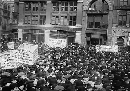
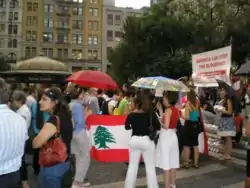
The park has historically been the start or the end point for many political demonstrations. Although the park was known for its labor union rallies and for the large 1861 gathering in support of Union troops, it was actually named for its location at the "union" of Bloomingdale Road (now Broadway) and Eastern Post Road (now extinct) decades before these gatherings.[6][68] In April 1861, soon after the fall of Fort Sumter, it was the site of a patriotic rally of perhaps a quarter of a million people that is thought to have been the largest public gathering in North America up to that time. In the summer of 1864 the north side of the square was the site of the Metropolitan Fair.
Union Square has been a frequent gathering point for radicals of all stripes to make speeches or demonstrate. In 1865, the recently formed Irish republican Fenian Brotherhood came out publicly and rented Dr. John Moffat's brownstone rowhouse at 32 East 17th Street, next to the Everett House hotel facing the north side of the square, for the capitol of the government-in-exile they declared.[69][70] On September 5, 1882, in the first Labor Day celebration, a crowd of at least 10,000 workers paraded up Broadway and filed past the reviewing stand at Union Square. On March 28, 1908, an anarchist set off a bomb in Union Square which only killed himself and another man.[71]
On August 21, 1893, Emma Goldman took the stage at Union Square to make her "Free Bread" speech to a crowd of overworked garment workers. She also addressed a crowd on May 20, 1916, on the need for free access to birth control which was banned by the Comstock laws. Her visits to Union Square pulled hundreds of followers; some of these rallies resulted in her arrest. Union Square has been used as a platform to raise awareness about the Black Lives Matter movement.
The Square's shopping district saw strikes in the S. Klein and Ohrbach department stores in 1934. White collar workers were among the worst paid in Great Depression era New York City, with union memberships being highly discouraged by store managers and often seen as fireable offenses. These strikes often involved acts of disobedience by the workers as many of them did not want to lose their jobs.[72] This period saw Union Square as a gathering point for many of the cities socialist and communist groups. The centennial of Union Square was seen as a thinly veiled effort to displace those elements with its draping of the square with flags and police demonstrations of anti protester drills.[73]
Street chess
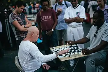
The Villager, a local newspaper, reported in 2013 that most of the street chess players at Washington Square Park—where Bobby Fischer had played—had moved their games to Union Square because the latter had more foot traffic.[74] Street chess players play fast chess with passers-by for three to five dollars a game, with time controls of five minutes on each side being the most common.[75] Writer Lauren Snetiker at the Greenwich Village Society for Historic Preservation also documents this migration of the historical Washington Square Park chess scene to Union Square, noting the "dozens of chess players [who] sit on crates and bring their own boards... as there are no permanent ones like there are in Washington Square Park".[76]
Union Square Partnership
The Union Square Partnership (USP), a business improvement district (BID) and a local development corporation (LDC), was formed in 1984 and became a model for other BIDs in New York City. As of 2006 it had a US$1.4 million budget. Jennifer E. Falk became its executive director in January 2007.[77]
The Union Square Partnership provides a free public Wi-Fi network in Union Square.[78]
Education
The Washington Irving Campus at 40 Irving Place between East 16th and 17th Streets, a block east of Union Square Park, was formerly the location of a comprehensive high school, but now houses Gramercy Arts High School, the High School for Language and Diplomacy, the International High School at Union Square, the Union Square Academy for Health Sciences and the Academy for Software Engineering. In 2012, Success Academy Charter Schools announced its plan to open an elementary school in the building in 2013,[79] but this had not occurred as of mid-2015.
Also in the Union Square neighborhood is the original building of Stuyvesant High School at 345 East 15th Street, now known as the "Old Stuyvesant Campus", and housing the Institute for Collaborative Education, the High School for Health Professions and Human Services, and P.S. 226.
Gallery
 Boy selling newspapers in Union Square, July 1910
 The square in the blizzard of 2006
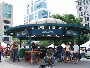 14th Street–Union Square station entrance
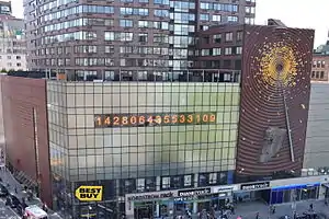 Metronome by Kristin Jones/Andrew Ginzel (1999)
 Metronome revision by Andrew Boyd and Gan Golan (2020)
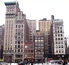 Union Square West (2011), including the Bank of the Metropolis Building and Decker Building, on the left (downtown) end of the block
 Former Germania Life Insurance Company Building, now the W New York Union Square Hotel
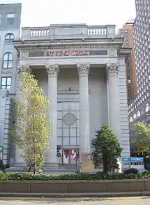 Former Union Square Savings Bank, now the Daryl Roth Theatre
 Zeckendorf Towers with the renovated north plaza of the park in the foreground, and the Con Ed Building in the background
See also
References
Notes
- "Parks for the New Metropolis (1811–1870)". New York City Department of Parks and Recreation. Retrieved March 27, 2008.
- "National Register Information System". National Register of Historic Places. National Park Service. January 23, 2007.
- "Union Square". National Historic Landmark summary listing. National Park Service. September 20, 2007. Archived from the original on October 29, 2007.
- Four Shortened – Manhattan's Shortest Numbered Avenue, Forgotten NY. Accessed January 16, 2018. "Among New York City's numbered avenues, 1st through 12th, 4th Avenue has always been the odd duck-- you can tell just by looking at a map. While most avenues are extraordinarily lengthy, spanning much of the island from north to south, 4th runs just six short blocks between Cooper and Union Squares; and while all of NYC's numbered avenues run parallel to the island's northward tilt (though not true north) 4th runs northwest athwart the other avenues, forming a 'V' at the Bowery at Cooper Square."
- Jenkins, Stephen (1911). The Greatest Street in the World: The Story of Broadway, Old and New, from Bowling Green to Albany. New York: Knickerbocker Press. OCLC 794027661.
- Federal Writers' Project (1939). "New York City Guide". New York: Random House. pp. 198–203. ISBN 978-1-60354-055-1. (Reprinted by Scholarly Press, 1976; often referred to as WPA Guide to New York City.)
- "New School: Map". The New School.
- "NYU: Map". New York University.
- "NYC Planning | Community Profiles". communityprofiles.planning.nyc.gov. New York City Department of City Planning. Retrieved March 18, 2019.
- "East Village, New York City-Manhattan, New York Zip Code Boundary Map (NY)". United States Zip Code Boundary Map (USA). Retrieved March 21, 2019.
- "NYPD – 13th Precinct". www.nyc.gov. New York City Police Department. Retrieved October 3, 2016.
- "Museum of the City of New York – [Map of land owned by Brevoort family at Bowery Lane]". collections.mcny.org. Retrieved December 10, 2019.
- "Getting Dressed: Gilded Age Afternoon Dress". Museum of the City of New York. Retrieved December 10, 2019.
- Jenkins, Stephen (1911). The Greatest Street in the World: The Story of Broadway, Old and New, from Bowling Green to Albany. New York: Knickerbocker Press. pp. 107. OCLC 794027661.
- Randel, John.City of New York, North of Canal Street, in 1808 to 1821. p. 7. (via the Library of Congress). Retrieved September 5, 2011.
- Burrows & Wallace, pp. 577 et passim.
- "Century Building" (PDF). New York City Landmarks Preservation Commission. October 7, 1986. p. 2. Retrieved November 12, 2019.
- Stokes, Isaac Newton Phelps (1915). "The iconography of Manhattan Island, 1498–1909 : compiled from original sources and illustrated by photo-intaglio reproductions of important maps, plans, views, and documents in public and private collections" – via Internet Archive.
- Schachter, Sophia; Gilbertson, Elsa (June 1982). Union Square (Unpublished manuscript). Program in Historic Preservation, Columbia University.
- Taylor, D.E. (2009). The Environment and the People in American Cities, 1600s–1900s: Disorder, Inequality, and Social Change. e-Duke books scholarly collection. Duke University Press. p. 233. ISBN 978-0-8223-9224-8. Retrieved December 10, 2019.
- Trager, James. Park Avenue: Street of Dreams, p. 18. Accessed August 31, 2018. Atheneum Books, 1990. ISBN 9780689120244. "Ruggles was also helping to develop a collection of vacant lots from 14th Street to 17th between Broadway and Fourth Avenue into Union Square, a 3.48-acre field indicated in the commissioners' plan as Union Place and renamed Union Square in 1832."
- Union Square Timeline, Columbia University. Accessed January 16, 2018. "In 1832, Samuel Buckley Ruggles obtained a fifty-year lease on the Union Place area."
- Roberts, S. (2014). A History of New York in 101 Objects. Simon & Schuster. p. 50. ISBN 978-1-4767-2880-3. Retrieved November 12, 2019.
- Staff (December 25, 1906). "Creditors Take Charge of the Everett House – Bankruptcy Petition Is Filed Against Famous Hostelry – Mortgage Also Foreclosed – A Woman Says She Lost All in Loan to President Seibert of the Hotel Company" (PDF). The New York Times. p. 4. Retrieved September 5, 2011.
- Olmsted and Vaux were carrying out their plan for Central Park; their plan, and the original plan, are represented in bronze plaques with very low relief, set into the sidewalks near the southwest and southeast corners.
- In the way that Piazza del Popolo functioned for Rome and Hyde Park Corner for London.
- Wollmann, Elizabeth L. (November 29, 2012). Hard Times: The Adult Musical in 1970s New York City. ISBN 9780199747481. Retrieved March 10, 2013.
- Bianco, Anthony (October 13, 2009). Ghosts of 42nd Street. ISBN 9780061847653. Retrieved March 10, 2013.
- Allen, Irving L. (February 23, 1995). City In Slang: New York Life and Popular Speech. ISBN 9780195357769. Retrieved March 10, 2013.
- Chesluk, Benjamin (2008). Money Jungle: Imagining the New Times Square. Rutgers Press. p. 19. ISBN 9780813543819.
- Burrows & Wallace, pp. 946–948.
- "Germania Life Insurance Company Building" (PDF). New York City Landmarks Preservation Commission. September 6, 1988. Retrieved October 10, 2019.
- "Plans for Everett House Site Improvement" (PDF). The Real Estate Record: Real Estate Record and Builders' Guide. 81 (2101): 1178. June 20, 1908 – via columbia.edu.
- "Tammany Hall" (PDF). New York City Landmarks Preservation Commission. October 29, 2013. Retrieved October 10, 2019.
- "Everett Building" (PDF). New York City Landmarks Preservation Commission. September 6, 1988. Retrieved October 10, 2019.
- Harris, Gale (February 10, 2009). "Consolidated Edison Company Building" (PDF). New York City Landmarks Preservation Commission. Retrieved November 18, 2019.
- "BULK OF TRADING ON THE EAST SIDE". The New York Times. June 8, 1928. ISSN 0362-4331. Retrieved November 25, 2019.
- Bond, John W. (March 6, 1996). ""Union Square", March 6, 1996, National Historic Landmark Nomination". National Park Service.
- "Union Square – Accompanying photos from 1995–1997 and illustration from 1882. National Historic Landmark Nomination". National Park Service. March 6, 1996.
- Siegel, Jefferson (December 13, 2006). "Opponents Pile on Union Sq. Pavillion Plan at Rally". The Villager. Retrieved May 27, 2008.
- "Groups Protest Planned Restaurant in Union Square Park". NY1. October 17, 2005. Retrieved May 27, 2008.
- "Judge Extends Injunction Against Union Square Restaurant". NY1. April 28, 2008. Retrieved May 27, 2008.
- Amateau, Albert (May 14, 2008). "Union Sq. Work Restart O.K.'d, But Pavilion Is on Back Burner". The Villager. Retrieved May 27, 2008.
- Gregorian, Dareh (March 31, 2009). "Judge Throws Out Suit Against Union Square Renovation and Seasonal Restaurant". New York Post. Retrieved May 30, 2010.
- "Lincoln Building" (PDF). New York City Landmarks Preservation Commission. July 12, 1988. Retrieved October 10, 2019.
- "5 Union Square – TRD Research". The Real Deal. Retrieved December 11, 2019.
- Gray, Christopher (July 2, 2006). "Before Tiffany & Co. Moved Uptown". The New York Times. ISSN 0362-4331. Retrieved December 9, 2019.
- "Bank of the Metropolis" (PDF). New York City Landmarks Preservation Commission. July 12, 1988. Retrieved October 10, 2019.
- "Union Building" (PDF). New York City Landmarks Preservation Commission. July 12, 1988. Retrieved October 10, 2019.
- "Union Square Savings Bank" (PDF). New York City Landmarks Preservation Commission. February 13, 1996. Retrieved October 10, 2019.
- One Union Square South was voted "New York's Ugliest Building" by a panel of architects assembled by the New York Post; results were published in the paper on January 9, 2000.
- "Century Association Building" (PDF). New York City Landmarks Preservation Commission. January 5, 1993. Retrieved October 10, 2019.
- "Union Square Park Monuments – George Washington : NYC Parks". www.nycgovparks.org. Retrieved November 27, 2019.
- "Union Square Park Monuments – Marquis de Lafayette : NYC Parks". www.nycgovparks.org. Retrieved November 27, 2019.
- "Union Square Park Monuments – Abraham Lincoln : NYC Parks". www.nycgovparks.org. Retrieved November 27, 2019.
- "Flyer for Gandhi Memorial Statue in New York City, dedicated on October 2, 1986" in the South Asian American Digital Archive (SAADA)
- "Union Square Park Monuments – Union Square Drinking Fountain : NYC Parks". www.nycgovparks.org. Retrieved November 27, 2019.
- "Union Square Park Monuments – Independence Flagstaff : NYC Parks". www.nycgovparks.org. Retrieved November 27, 2019.
- McGroarty, Jane. "Issue 2: Community Scale Economics". Retrieved August 4, 2007.
- "Greenmarket Facts". Retrieved August 4, 2007.
- "Greenmarket Facts". Retrieved August 4, 2007.
- Fishman, Steve (April 7, 2003). "Manhattan Gets Fresh". New York. Retrieved August 4, 2007.
- "Postings: S. Klein Renovation; Something New on the Square". The New York Times. September 29, 1991. ISSN 0362-4331. Retrieved September 1, 2020.
- Stamler, Bernard (February 14, 1999). "New Yorkers & Co.; Full Circle at Union Square". The New York Times. ISSN 0362-4331. Retrieved November 12, 2019.
- Ryzik, Melena (August 19, 2007). "A Harmonic Convergence in Union Square". The New York Times. ISSN 0362-4331. Retrieved September 1, 2020.
- Allon, Janet (July 20, 1997). "Superstore Supersign Superfluous to Some". The New York Times. ISSN 0362-4331. Retrieved December 13, 2019.
- Louie, Elaine (December 7, 2000). "CURRENTS: HOTELS; On Union Square, a Sweeping Staircase With a Ballroom to Match". The New York Times. ISSN 0362-4331. Retrieved November 25, 2019.
- "Union Square – Historical Sign". New York City Department of Parks and Recreation. Retrieved December 12, 2006.
- Burrows & Wallace, p. 1,005.
- Ramón-García, M."Square-Toed Boots and Felt Hats: Irish Revolutionaries and the Invasion of Canada" Archived April 25, 2012, at the Wayback Machine. Estudios Irlandeses 2010:87 (via Google Books).
- Union Square bombing.
- "Monkey Business in Union Square: A Cultural Analysis of the Klein's-Ohrbach's Strikes of 1934–5". Journal of Social History. 36 (1).
- Merwood-Salisbury, Joanna (2009). "Patriotism and Protest: Union Square as Public Space, 1832–1932". Journal of the Society of Architectural Historians. 68 (4): 555–556. doi:10.1525/jsah.2009.68.4.540.
- Hines, Lael (August 8, 2008). "Chess moves: Most players are now at Union Square". The Villager. Retrieved August 27, 2015.
- Roma, Giancarlo. "A Black and White Game: The Chess Players of Union Square". Vice. Retrieved October 15, 2015.
- Snetiker, Lauren (September 3, 2015). "Checkmate!: Street Chess in the Village". Greenwich Village Society for Historic Preservation. Retrieved October 15, 2015.
- Engquist, Erik (January 17, 2007). "BID Executive Makes Plans for Progress". Crain's New York Business. Retrieved May 30, 2010.
- Union Square Partnership (July 3, 2014). "Union Square Partnership Expands Free Wi-Fi Hot Zone (press release)". Retrieved March 10, 2013.
- Fleisher, Lisa (July 15, 2012). "New Charters Proposed for Manhattan". The Wall Street Journal. Retrieved July 25, 2012.
Bibliography
- Burrows, Edwin G. & Wallace, Mike (1999). Gotham: A History of New York City to 1898. New York: Oxford University Press. ISBN 0-195-11634-8.
External links
| Wikimedia Commons has media related to Union Square, Manhattan. |
| Wikivoyage has a travel guide for Gramercy Flatiron (incl. Union Square). |
- A History of Union Square, on the New York City Department of Parks & Recreation website
- Union Square Partnership
- Union Square Greenmarket
- GrowNYC Greenmarket Farmer's Markets Official Site

.JPG.webp)
