Administrative divisions of Romania
Romania 's administration is relatively centralized and administrative subdivisions are therefore fairly simplified.
 |
|---|
| This article is part of a series on the politics and government of Romania |
|
|
According to the Constitution of Romania, its territory is organized administratively into communes , cities and counties :[1]
- At the county level: 41 counties, and one city with special status (Bucharest, the national capital)
- At the town / commune level: 103 municipalities and 217 other cities (for urban areas), and 2861 communes (for rural areas).[2] Municipality (municipiu) status is accorded to larger towns, but it does not give their administrations any greater powers.
Below communal or town level, there are no further formal administrative subdivisions. However, communes are divided into villages (which have no administration of their own). There are 12,957 villages in Romania. The only exception is Bucharest , which has six sectors, each with an administration of its own.
Historic

The earliest organization into județe of the Principalities of Wallachia,[3] respectively ținuturi of Moldavia, dates back at least to the early 15th century. Each județ, respectively ținut, was ruled by a jude, respectively pârcălab, an officially appointed person who had administrative and judicial functions in a manner inspired from the organization of the late Byzantine Empire. Transylvania, when it was part of the historic Kingdom of Hungary (in the Middle Ages), an independent Principality or a Habsburg domain (in the modern era until World War I) was divided into royal counties (Latin:comitatus), headed by comes (royal counts) with administrative and judicial functions. The term județ became used in Romanian universally for all principalities since mid-19th century.
.svg.png.webp)
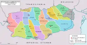
After modern Romania was formed in 1859 through the union of Wallachia and rump Moldavia, and then extended in 1918 through the union of Transylvania, as well as Bukovina and Bessarabia (parts of Moldavia temporarily acquired by the Habsburgs, 1775–1918, respectively the Russian Tsars, 1812–1917), the administrative division was modernized using the French departments system as an example. With the exception of the half of the Communist period, this system remained in place. Since 1864, for each județ there exists a prefect (from the Latin praefectus), a subordinate of the Ministry of Internal Affairs, who is the representative of the government in the county, and the head of the local administration in the areas not delegated to local authorities.[4] Until 1948, each județ was further divided into a number of plăși (singular plasă), with each administered by a pretor (from the Latin praetor), appointed by the prefect.[5]
In 1913, as a result of the Second Balkan War, Romania acquired Southern Dobruja from Bulgaria, integrating this historical region within Romania's borders until 1940. In 1923 Romania adopted a new Constitution, and in 1927 it uniformized the traditional administrative systems of Transylvania, Bukovina and Bessarabia with that of the Romanian Old Kingdom. County borders were kept largely intact, with only a couple minor adjustments, as a total of 71 județe existed between 1927 and 1938.
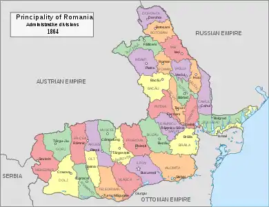
In 1938, King Carol II modified the Constitution, and after that the law of administration of the Romanian territory. Ten "ținuturi" (approx. translation: "lands") were created, ruled by "Rezidenți Regali" (approx. translation "Royal Residents"), appointed directly by the Monarch. The ținuturi represented another layer of administration between counties and the country; county borders were not erased.[4][6] But, due to World War II, the Second Vienna Award, the Ribbentrop-Molotov pact and the loss of territory that Romania suffered, this style of administration did not last, the administration at the "județ" level being reintroduced back until the establishment of communism in 1945-1947.
During World War II, the territory of Romania suffered very significant modifications. In 1940, Soviet Union occupied Bessarabia, northern Bukovina, and Herza region which after the fall of the Soviet Union in 1991, would become part of Republic of Moldova and of Ukraine. Between 1941-1944, these territories together with Transnistria, were administered by Romania briefly, as the country was governed by a military dictatorship allied with Nazi Germany. Transnistria consisted of formerly proper Soviet territory between Dniester and Southern Bug rivers. Nowadays, most of it is in Ukraine, with small parts in the Republic of Moldova (current Transnistria). This territory was kept under Romanian military occupation, and was not annexed to Romania consisted of a further 13 counties.

After the war, the Communist Party took over the administration of the country. In 1950, the party changed the administration model to the Russian model (regions and raions), but it reverted to the current system in 1968, although county borders were quite different from the interbelic period.[7] In 1981 the former counties of Ilfov and Ialomița were re-organised into the present-day counties of Giurgiu, Călărași, Ialomița and Ilfov. The county borders introduced in 1968 are largely in place, but administrative reform during the 1990s has devolved the functions of different authorities in line with transition from a totalitarian communist system to a modern democracy. The only territorial adjustment after 1989 occurred in 1995, when Ilfov County was formed. Before that it was a dependency of the Municipality of Bucharest (Sectorul Agricol Ilfov).
Current status
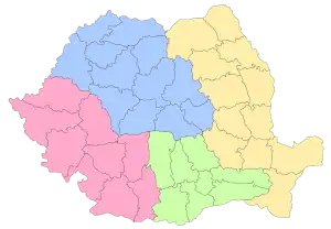
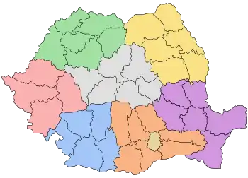
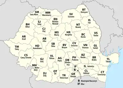
Eight regional divisions (called development regions) were created in 1998 in order to better co-ordinate regional development as Romania progressed towards accession to the European Union, and consist of several counties each. These correspond to NUTS II-level divisions in European Union member states, but do not actually have an administrative status and do not have a legislative or executive council or government. As of 2009, Romania is divided into 41 counties and one municipality which are assigned as NUTS III-level divisions. Currently, Romania has no NUTS-4 units, the counties being composed directly of cities (some of which with municipality status) and communes.
As in all modern democracies, the political power in Romania is divided into three independent branches: legislative, executive, and judicial. The prefect and his administration have only executive prerogatives. However, the territorial districts of the Romanian judicial system overlap with county borders, thus avoiding further complication.[4] At the same time with local elections (of mayors and councilors for the cities and communes), a Consiliu județean (County Council) is elected for each county. From 2008 to 2016 a President of the County Council was also elected by direct vote, from 2016 he or she has been (as prior to 2008) elected by a Council. As of now, the legislative powers of county councils are quite reduced, but there are plans for more decentralization. (These plans, however, call for introduction of Regional Councils for the 8 development regions of the NUTS-2 level.)
Future developments
As of 2010 there have been several proposals for the administrative reorganization of Romania made by the presidential commission tasked with the analysis of the political and constitutional regime.[8] Most of these recommendations aim for the partial reestablishment of the counties in their pre-1950 form. The counties will be grouped into several regions (9 to 15) based on common historical and economic characteristics (NUTS II level). The regions will be in their turn clustered into 4-6 macroregions (NUTS I level). Furthermore, a NUTS IV level division, called plasă or canton will probably be added in order to meet the EU statistical and administrative requirements.[9]
Another proposal, based on 15 autonomous euro-regions (amongst them one ethnic based region with a consistent Hungarian majority made of the existing Mureș, Harghita and Covasna counties) grouped into 5 statistical macroregions (NUTS I), was made by the Democratic Union of Hungarians in Romania (UDMR).[10]
Nomenclature of Territorial Units for Statistics (NUTS)
For statistical and development purposes, Romania, in the NUTS scheme, is divided into:
- NUTS I level: 4 macroregions (macroregiune in Romanian), used for appropriation of European development funds
- NUTS II level: 8 development regions, with an average population of 2.8 million inhabitants per region, although not administrative divisions per se, have been used for decades for statistical purposes by the Romanian National Commission of Statistics (NCS). Recently they also exist to co-ordinate regional development and appropriation of European development funds
- NUTS III level: 41 counties and one municipality (Bucharest, the national capital) reflecting Romania's official administrative-territorial structure
- LAU I level: not used, as territorial units associations have not been identified yet;
- LAU II level: 217 cities and 103 municipalities (for urban areas), and 2,856 communes (for rural areas)
An exception to this structure is the Municipality of Bucharest, which is a secondary division (rather than a tertiary division like other municipalities) and is officially divided into six sectors, each sector having a local government and council.
The eight development regions (specific territorial entities without administrative status or legal personality) represent the framework for collecting specific statistical data, according to the European regulations issued by Eurostat for the Nomenclature of Territorial Units for Statistics (NUTS) II territorial level. According to the Emergency Government Ordinance No 75/2001 on the functioning of the National Institute for Statistics, eight Directorates General for regional statistics have been created, and together with the 34 county directorates for statistics, aim at developing regional statistics. Officially, the eight regions are Nord-Est (North-East), Sud-Est (South-East), Sud - Muntenia (South - Muntenia), Sud-Vest Oltenia (South-West Oltenia), Vest (West), Nord-Vest (North-West), Centru (Centre), and București - Ilfov (Bucharest - Ilfov). The criteria used by NCS for delimiting the regions is a combination of geographical location and homogeneity based on population density. Alternative historical names are also used, but remain unofficial.
| no | type | name | area, km2 | population (mid-2007 official estimate) | municipalities | other cities | communes | villages |
|---|---|---|---|---|---|---|---|---|
| 1 | Nord-Est development region | 36,850 | 17 | 29 | 506 | 2,414 | ||
| 1 | county | Bacău County | 6,621 | 719,844 | 3 | 5 | 85 | 491 |
| 2 | county | Botoșani County | 4,986 | 454,167 | 2 | 5 | 71 | 333 |
| 3 | county | Iași County | 5,476 | 825,100 | 2 | 3 | 93 | 418 |
| 4 | county | Neamț County | 5,896 | 566,059 | 2 | 3 | 78 | 344 |
| 5 | county | Suceava County | 8,553 | 705,878 | 5 | 11 | 98 | 379 |
| 6 | county | Vaslui County | 5,318 | 455,594 | 3 | 2 | 81 | 449 |
| 2 | Sud-Est development region | 35,762 | 11 | 24 | 355 | 1,448 | ||
| 7 | county | Brăila County | 4,766 | 365,628 | 1 | 3 | 40 | 140 |
| 8 | county | Buzău County | 6,103 | 488,763 | 2 | 3 | 82 | 475 |
| 9 | county | Constanța County | 7,071 | 718,330 | 3 | 9 | 58 | 189 |
| 10 | county | Galați County | 4,466 | 614,449 | 2 | 2 | 61 | 180 |
| 11 | county | Tulcea County | 8,499 | 250,641 | 1 | 4 | 46 | 133 |
| 12 | county | Vrancea County | 4,857 | 392,619 | 2 | 3 | 68 | 331 |
| 3 | Sud - Muntenia development region | 34,453 | 16 | 32 | 519 | 2,019 | ||
| 13 | county | Argeș County | 6,826 | 644,236 | 3 | 4 | 95 | 576 |
| 14 | county | Călărași County | 5,088 | 315,187 | 2 | 3 | 50 | 160 |
| 15 | county | Dâmbovița County | 4,054 | 533,330 | 2 | 5 | 82 | 353 |
| 16 | county | Giurgiu County | 3,526 | 283,408 | 1 | 2 | 51 | 167 |
| 17 | county | Ialomița County | 4,453 | 290,563 | 3 | 4 | 59 | 127 |
| 18 | county | Prahova County | 4,716 | 821,013 | 2 | 12 | 90 | 405 |
| 19 | county | Teleorman County | 5,790 | 413,064 | 3 | 2 | 92 | 231 |
| 4 | Sud-Vest Oltenia development region | 29,212 | 11 | 29 | 408 | 2,070 | ||
| 20 | county | Dolj County | 7,414 | 712,187 | 3 | 4 | 104 | 378 |
| 21 | county | Gorj County | 5,602 | 381,643 | 2 | 7 | 61 | 411 |
| 22 | county | Mehedinți County | 4,933 | 298,741 | 2 | 3 | 61 | 344 |
| 23 | county | Olt County | 5,498 | 475,702 | 2 | 6 | 104 | 377 |
| 24 | county | Vâlcea County | 5,765 | 411,576 | 2 | 9 | 78 | 560 |
| 5 | Vest development region | 32,034 | 12 | 30 | 281 | 1,327 | ||
| 25 | county | Arad County | 7,754 | 457,713 | 1 | 9 | 68 | 270 |
| 26 | county | Caraș-Severin County | 8,520 | 327,579 | 2 | 6 | 69 | 287 |
| 27 | county | Hunedoara County | 7,063 | 472,284 | 7 | 7 | 55 | 457 |
| 28 | county | Timiș County | 8,697 | 666,866 | 2 | 8 | 89 | 313 |
| 6 | Nord-Vest development region | 34,159 | 15 | 28 | 403 | 1,800 | ||
| 29 | county | Bihor County | 7,544 | 594,131 | 4 | 6 | 91 | 430 |
| 30 | county | Bistrița-Năsăud County | 5,355 | 316,689 | 1 | 3 | 58 | 235 |
| 31 | county | Cluj County | 6,674 | 692,316 | 5 | 1 | 75 | 420 |
| 32 | county | Maramureș County | 6,304 | 513,000 | 2 | 11 | 63 | 214 |
| 33 | county | Satu Mare County | 4,418 | 366,270 | 2 | 4 | 59 | 220 |
| 34 | county | Sălaj County | 3,864 | 243,157 | 1 | 3 | 57 | 281 |
| 7 | Centru development region | 34,100 | 20 | 37 | 357 | 1,788 | ||
| 35 | county | Alba County | 6,242 | 376,086 | 4 | 7 | 67 | 656 |
| 36 | county | Brașov County | 5,363 | 593,928 | 4 | 6 | 48 | 149 |
| 37 | county | Covasna County | 3,710 | 223,364 | 2 | 3 | 40 | 122 |
| 38 | county | Harghita County | 6,639 | 325,611 | 4 | 5 | 58 | 235 |
| 39 | county | Mureș County | 6,714 | 581,759 | 4 | 7 | 91 | 464 |
| 40 | county | Sibiu County | 5,432 | 423,156 | 2 | 9 | 53 | 162 |
| 8 | București - Ilfov development region | 1,821 | 1 | 8 | 32 | 91 | ||
| 41 | county | Ilfov County | 1,583 | 294,094 | - | 8 | 32 | 91 |
| 42 | municipality | Bucharest | 238 | 1,931,838 | 1 | - | - | - |
| Total | 238,391 | N/A | 103 | 217 | 2,861 | 12,957 | ||
See also
References
- Law 151/1998 regarding the regional development in Romania was published in "Monitorul Oficial" on July 16, 1998, being approved by the Romanian Parliament. MIE Chapter 21
- Constitution of Romania, Title I, article 3
- 2017 Romanian Statistical Yearbook, p. 17
- "De la sat la județ în istoria Olteniei | Vertical". Verticalonline.ro. Retrieved 2010-07-08.
- "Instituția Prefectului județul Argeș". Prefecturaarges.ro:8080. Archived from the original on 2012-05-20. Retrieved 2010-07-08.
- Sorin Damian. "Județul Buzău". Buzau.com. Archived from the original on 2009-02-14. Retrieved 2010-07-08.
- (in Romanian) Ioan Scurtu, Theodora Stănescu-Stanciu, Georgiana Margareta Scurtu, Istoria românilor între anii 1918-1940: VIII. Viața politică în perioada februarie 1938-septembrie 1940 ("The History of the Romanians in 1918-1940): IV. Political Life in the February 1938-September 1940 Period" Archived November 16, 2007, at the Wayback Machine: "Decret-lege pentru reforma electorală" ("Law Decree for Electoral Reform") Archived 2007-07-01 at the Wayback Machine
- "Istoria Banatului :: În linii mari". Vestul.ro. 1944-08-23. Archived from the original on 2013-05-21. Retrieved 2010-07-08.
- "Microsoft Word - RAPORTUL STANOMIR.doc" (PDF). Archived (PDF) from the original on 15 August 2010. Retrieved 2010-07-08.
- https://web.archive.org/web/20140523230804/http://www.romanialibera.ro/dosar/a129846-cum-va-arata-harta-romaniei.html. Archived from the original on May 23, 2014. Retrieved March 24, 2010. Missing or empty
|title=(help) - https://web.archive.org/web/20100421045240/http://www.gandul.info/politica/reorganizare-teritoriala-marca-udmr-15-euroregiuni-15-parlamente-955641. Archived from the original on April 21, 2010. Retrieved March 24, 2010. Missing or empty
|title=(help)