Lacombe County
Lacombe County is a municipal district in central Alberta, Canada, located in Census Division No. 8 north of the City of Red Deer. Its municipal office is 4 km (2.5 mi) west of Highway 2 and the City of Lacombe, and 6 km (3.7 mi) east of the Summer Village of Gull Lake, at the intersection of Highway 12 and Spruceville Road (Range Road 274).
Lacombe County | |
|---|---|
Municipal district | |
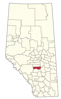 Location within Alberta | |
| Country | |
| Province | |
| Region | Central Alberta |
| Census division | No. 8 |
| Established | 1944 |
| Incorporated | 1995 |
| Government | |
| • Reeve | Paula Law |
| • Governing body | Lacombe County Council
|
| • MP | Blaine Calkins |
| • Office location | west of Lacombe |
| Area (2016)[2] | |
| • Land | 2,765.16 km2 (1,067.63 sq mi) |
| Population (2016)[2] | |
| • Total | 10,343 |
| • Density | 3.7/km2 (10/sq mi) |
| Time zone | UTC-7 (MST) |
| Website | lacombecounty.com |
Demographics
In the 2016 Census of Population conducted by Statistics Canada, Lacombe County recorded a population of 10,343 living in 3,890 of its 4,668 total private dwellings, a 0.3% change from its 2011 population of 10,307. With a land area of 2,765.16 km2 (1,067.63 sq mi), it had a population density of 3.7/km2 (9.7/sq mi) in 2016.[2]
In the 2011 Census, Lacombe County had a population of 10,312 living in 3,715 of its 4,317 total dwellings, a -0.8% change from its 2006 adjusted population of 10,394. With a land area of 2,766.65 km2 (1,068.21 sq mi), it had a population density of 3.7/km2 (9.7/sq mi) in 2011.[3]
The population of Lacombe County according to its 2008 municipal census is 10,507.[4]
Communities and localities
|
The following urban municipalities are surrounded by Lacombe County:[5][6] The following hamlets are located within Lacombe County:[6]
|
The following localities are located within Lacombe County:[7]
|
|
References
- "Municipal Officials Search". Alberta Municipal Affairs. September 22, 2017. Retrieved September 25, 2017.
- "Population and dwelling counts, for Canada, provinces and territories, and census subdivisions (municipalities), 2016 and 2011 censuses – 100% data (Alberta)". Statistics Canada. February 8, 2017. Retrieved February 8, 2017.
- "Population and dwelling counts, for Canada, provinces and territories, and census subdivisions (municipalities), 2011 and 2006 censuses (Alberta)". Statistics Canada. February 8, 2012. Retrieved February 8, 2012.
- "Alberta 2009 Official Population List" (PDF). Alberta Municipal Affairs. September 15, 2009. Retrieved September 12, 2010.
- "Lacombe, City (Census Subdivision), Alberta". Statistics Canada. 2012-06-20. Retrieved 2012-08-13.
- "Specialized and Rural Municipalities and Their Communities" (PDF). Alberta Municipal Affairs. 2012-03-01. Archived from the original (PDF) on 2012-04-09. Retrieved 2012-08-11.
- "Standard Geographical Classification (SGC) 2006, Economic Regions: 4808022 - Lacombe County, geographical codes and localities, 2006". Statistics Canada. 2010-03-05. Retrieved 2012-08-11.
External links
Places adjacent to Lacombe County | |
|---|---|