Arrans
Arrans is a commune in the Côte-d'Or department in the Bourgogne-Franche-Comté region of eastern France.
Arrans | |
|---|---|
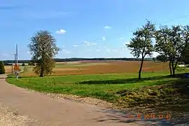 The landscape of Arrans | |
Location of Arrans 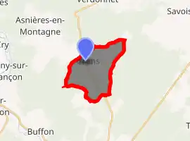
| |
 Arrans  Arrans | |
| Coordinates: 47°41′48″N 4°19′10″E | |
| Country | France |
| Region | Bourgogne-Franche-Comté |
| Department | Côte-d'Or |
| Arrondissement | Montbard |
| Canton | Montbard |
| Intercommunality | CC Montbardois |
| Government | |
| • Mayor (2014-2020) | Yolaine de Courson |
| Area 1 | 10.52 km2 (4.06 sq mi) |
| Population (2017-01-01)[1] | 73 |
| • Density | 6.9/km2 (18/sq mi) |
| Time zone | UTC+01:00 (CET) |
| • Summer (DST) | UTC+02:00 (CEST) |
| INSEE/Postal code | 21025 /21500 |
| Elevation | 249–332 m (817–1,089 ft) (avg. 320 m or 1,050 ft) |
| 1 French Land Register data, which excludes lakes, ponds, glaciers > 1 km2 (0.386 sq mi or 247 acres) and river estuaries. | |
Geography
Arrans is located some 6 km north of Montbard and 5 km south-east of Asnières-en-Montagne. Access to the commune is by the D5 road from Montbard in the south which passes through the heart of the commune and the village and continues north to Verdonnet. The D119 road also links the village to Asnières-en-Montagne in the north-west. The D5E branches off the D5 in the commune and goes south-west to Saint-Rémy. The commune is mostly forest with farmland around and east of the village.[2]
Neighbouring communes and villages
Places adjacent to Arrans | |
|---|---|
Administration

List of Successive Mayors[3]
| From | To | Name | Party | Position |
|---|---|---|---|---|
| 2001 | 2008 | Jean-Pierre Vaillant | ||
| 2008 | 2014 | Thomas Vaillant | ||
| 2014 | 2020 | Yolaine de Courson |
(Not all data is known)
Demography
In 2017 the commune had 73 inhabitants.
|
| ||||||||||||||||||||||||||||||||||||||||||||||||||||||||||||||||||||||||||||||||||||||||||||||||||||||||||||||||||
| Source: EHESS[4] and INSEE[5] | |||||||||||||||||||||||||||||||||||||||||||||||||||||||||||||||||||||||||||||||||||||||||||||||||||||||||||||||||||
Religious heritage
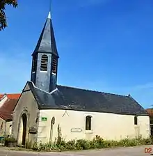
The Parish Church of Saint-Pierre-Célestin contains 2 Monumental Paintings of Saint Ambroise and Saint Nicolas (16th century)![]() that are registered as an historical object.[6]
that are registered as an historical object.[6]
See also
References
- "Populations légales 2017". INSEE. Retrieved 6 January 2020.
- Google Maps
- List of Mayors of France (in French)
- Des villages de Cassini aux communes d'aujourd'hui: Commune data sheet Arrans, EHESS. (in French)
- Population en historique depuis 1968, INSEE
- Ministry of Culture, Palissy IM21008600 2 Monumental Paintings of Saint Ambroise and Saint Nicolas (in French)
External links
- Arrans on the National Geographic Institute website (in French)
- Arrans on Lion1906
- Arrans on Géoportail, National Geographic Institute (IGN) website (in French)
- Gd. Aran on the 1750 Cassini Map
| Wikimedia Commons has media related to Arrans. |
| Authority control |
|
|---|