Bagnot
Bagnot is a commune in the Côte-d'Or department in the Bourgogne-Franche-Comté region of eastern France.
Bagnot | |
|---|---|
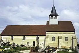 The Church of the Nativity | |
Location of Bagnot 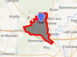
| |
 Bagnot  Bagnot | |
| Coordinates: 47°03′36″N 5°04′35″E | |
| Country | France |
| Region | Bourgogne-Franche-Comté |
| Department | Côte-d'Or |
| Arrondissement | Beaune |
| Canton | Brazey-en-Plaine |
| Intercommunality | Rives de Saône |
| Government | |
| • Mayor (2020–2026) | Mary-Claude Thurillat |
| Area 1 | 12.57 km2 (4.85 sq mi) |
| Population (2017-01-01)[1] | 161 |
| • Density | 13/km2 (33/sq mi) |
| Time zone | UTC+01:00 (CET) |
| • Summer (DST) | UTC+02:00 (CEST) |
| INSEE/Postal code | 21042 /21700 |
| Elevation | 189–216 m (620–709 ft) (avg. 197 m or 646 ft) |
| 1 French Land Register data, which excludes lakes, ponds, glaciers > 1 km2 (0.386 sq mi or 247 acres) and river estuaries. | |
The inhabitants of the commune are known as Bagnotins or Bagnotines.[2]
Geography
Bagnot is located some 30 km south of Dijon and 15 km east by north-east of Beaune. Access to the commune is by the D20 from Argilly in the west which passes through the village and continues east to Auvillars-sur-Saône. The D35E goes south from the village to the D973. The A36 autoroute passes through the south of the commune from west to east but has no exit in the commune. The nearest exit is Exit ![]() 1 some 5 km east of the commune. The commune is extensively forested in the south with forests also in the north-west; the centre of the commune is farmland.[3]
1 some 5 km east of the commune. The commune is extensively forested in the south with forests also in the north-west; the centre of the commune is farmland.[3]
The Sereine river flows through the commune and the village from the north-east and continues south-west to join the Meuzin near Palleau. Two tributaries feed the Sereine from the commune - one fed by the Étang de Menans just west of the commune and the other from the Grand Étang west of the village. Another stream rises in the east of the commune and flows east through the Étang Limonet and Étang du Moulin, both just east of the commune, to the Saône river at Glanon.[3]
Neighbouring communes and villages
Places adjacent to Bagnot | |
|---|---|
Administration
| From | To | Name | Party | Position |
|---|---|---|---|---|
| 2001 | 2026 | Mary Claude Thurillat |
(Not all data is known)
Demography
In 2017 the commune had 161 inhabitants.
|
| ||||||||||||||||||||||||||||||||||||||||||||||||||||||||||||||||||||||||||||||||||||||||||||||||||||||||||||||||||
| Source: EHESS[5] and INSEE[6] | |||||||||||||||||||||||||||||||||||||||||||||||||||||||||||||||||||||||||||||||||||||||||||||||||||||||||||||||||||
Culture and heritage
Civil heritage
The commune has a number of buildings and structures that are registered as historical monuments:
- A Farmhouse at CVO 2 Meix Martin (18th century)
 [7]
[7] - A Farmhouse at D20 (1842)[8]
- A Town Hall/School at D20 (19th century)[9]
- A Farmhouse at Les Granges de Bagnot (18th century)[10] The Farmhouse contains a Statue of the Sacred Heart (19th century)
 which is registered as an historical object.[11]
 - Houses and Farms (18th-19th century)[12]
Religious heritage
The commune has several religious buildings and sites that are registered as historical monuments:
- A Cemetery Cross at D20 (19th century)[13]
- A Presbytery at D20 (19th century)[14]
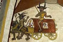
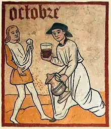
- The Church of the Nativity (12th century).[15] The Church is a Romanesque building novel originally from the 12th and 13th centuries and later redesigned. It is decorated with murals from the 15th century (they are dated 1484) on the theme of the Last Judgment which were discovered in 1862. In particular there are the Diables de Bagnot (The Devils of Bagnot) that made this church famous. The walls and the choir vaults depict scenes from sacred history: The Annunciation, Saints, Evangelists, and donors. The arch in the choir is decorated with a calendar representing the twelve months of the year with scenes of daily life. The Church contains a large number of items that are registered as historical objects. For a complete list including links to descriptions (in French) click here.
See also
References
- "Populations légales 2017". INSEE. Retrieved 6 January 2020.
- Inhabitants of Côte-d'Or (in French)
- Google Maps
- List of Mayors of France (in French)
- Des villages de Cassini aux communes d'aujourd'hui: Commune data sheet Bagnot, EHESS. (in French)
- Population en historique depuis 1968, INSEE
- Ministry of Culture, Mérimée IA00070878 Farmhouse at CVO 2 Meix Martin (in French)
- Ministry of Culture, Mérimée IA00070879 Farmhouse at D20 (in French)
- Ministry of Culture, Mérimée IA00070876 Town Hall/School at D20 (in French)
- Ministry of Culture, Mérimée IA00070881 Farmhouse at Les Granges de Bagnot (in French)
- Ministry of Culture, Palissy IM21000090 Statue: Sacred Heart (in French)
- Ministry of Culture, Mérimée IA00070874 Houses and Farms (in French)
- Ministry of Culture, Mérimée IA00070880 Cemetery Cross (in French)
- Ministry of Culture, Mérimée IA00070877 Presbytery (in French)
- Ministry of Culture, Mérimée PA00112092 IA00070875 Church of the Nativity (in French)

External links
- Bagnot on the old National Geographic Institute website (in French)
- Bagnot on Lion1906
- Bagnot on Géoportail, National Geographic Institute (IGN) website (in French)
- Bagnot on the 1750 Cassini Map
| Wikimedia Commons has media related to Bagnot. |
| Authority control |
|---|