Bure-les-Templiers
Bure-les-Templiers is a commune in the Côte-d'Or department in eastern France.
Bure-les-Templiers | |
|---|---|
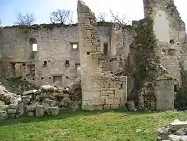 Ruins of the Templar commandery | |
.svg.png.webp) Coat of arms | |
Location of Bure-les-Templiers 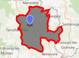
| |
 Bure-les-Templiers  Bure-les-Templiers | |
| Coordinates: 47°44′21″N 4°53′45″E | |
| Country | France |
| Region | Bourgogne-Franche-Comté |
| Department | Côte-d'Or |
| Arrondissement | Montbard |
| Canton | Châtillon-sur-Seine |
| Intercommunality | Pays Châtillonnais |
| Government | |
| • Mayor (2008–2014) | Jean-Charles Colombo |
| Area 1 | 35.03 km2 (13.53 sq mi) |
| Population (2017-01-01)[1] | 134 |
| • Density | 3.8/km2 (9.9/sq mi) |
| Time zone | UTC+01:00 (CET) |
| • Summer (DST) | UTC+02:00 (CEST) |
| INSEE/Postal code | 21116 /21290 |
| Elevation | 302–483 m (991–1,585 ft) (avg. 315 m or 1,033 ft) |
| 1 French Land Register data, which excludes lakes, ponds, glaciers > 1 km2 (0.386 sq mi or 247 acres) and river estuaries. | |
Population
| Year | Pop. | ±% |
|---|---|---|
| 1962 | 187 | — |
| 1968 | 211 | +12.8% |
| 1975 | 172 | −18.5% |
| 1982 | 154 | −10.5% |
| 1990 | 130 | −15.6% |
| 1999 | 150 | +15.4% |
| 2008 | 130 | −13.3% |
See also
References
- "Populations légales 2017". INSEE. Retrieved 6 January 2020.
| Wikimedia Commons has media related to Bure-les-Templiers. |
| Authority control |
|
|---|
This article is issued from Wikipedia. The text is licensed under Creative Commons - Attribution - Sharealike. Additional terms may apply for the media files.