Baulme-la-Roche
Baulme-la-Roche is a commune in the Côte-d'Or department in the Bourgogne-Franche-Comté region of eastern France.[3]
Baulme-la-Roche | |
|---|---|
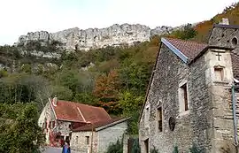 A general view of Baulme-la-Roche | |
.svg.png.webp) Coat of arms | |
Location of Baulme-la-Roche 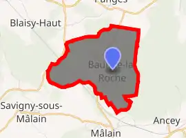
| |
 Baulme-la-Roche  Baulme-la-Roche | |
| Coordinates: 47°20′48″N 4°47′59″E | |
| Country | France |
| Region | Bourgogne-Franche-Comté |
| Department | Côte-d'Or |
| Arrondissement | Dijon |
| Canton | Talant |
| Intercommunality | Sombernonnais |
| Government | |
| • Mayor (2020–2026) | Raphaël Véjux[1] |
| Area 1 | 6.69 km2 (2.58 sq mi) |
| Population (2017-01-01)[2] | 90 |
| • Density | 13/km2 (35/sq mi) |
| Time zone | UTC+01:00 (CET) |
| • Summer (DST) | UTC+02:00 (CEST) |
| INSEE/Postal code | 21051 /21410 |
| Elevation | 360–596 m (1,181–1,955 ft) (avg. 450 m or 1,480 ft) |
| 1 French Land Register data, which excludes lakes, ponds, glaciers > 1 km2 (0.386 sq mi or 247 acres) and river estuaries. | |
The inhabitants of the commune are known as Rochebalmiens or Rochebalmiennes.[4]
Geography
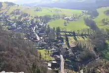
Baulme-la-Roche is located some 17 km west by north-west of Dijon and 8 km north-east of Sombernon. Access to the commune is by the D104C from Mâlain in the south which passes through the commune and the village and continues north-east to join the D10 south-east of Panges. The Paris–Marseille railway passes through the commune and the entrance to the Blaisy-Bas Tunnel is in the commune. The nearest station is at Malain south of the commune. The commune is mostly farmland but there are extensive forests - especially in the east.[5][6]
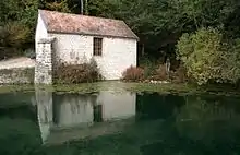
The Douix river rises in the west of the commune and flows south-east to join the Ouche east of Sainte-Marie-sur-Ouche. The Ruisseau de Baulme-la-Roche rises in the centre of the commune and flows south-west to join the Douix.[5][6]
Neighbouring communes and villages[5] | ||||||||||
|---|---|---|---|---|---|---|---|---|---|---|
| ||||||||||
Toponymy
Baulme-la-Roche appears as Beaume la Roche on the 1750 Cassini Map[7] and the same on the 1790 version.[8]
Heraldry
Arms of Baulme-la-Roche |
Blazon: Party per fess, at 1 party per pale, Argent a cross Gules charged with 5 roses and Azure a dexter arm carnation vested Argent holds a crozier of Or; at 2 Azure, a mountain of 3 hillocks of Or; all debruised by a barrulet on the division charged with a fess wavy of Azure. |
Administration
| From | To | Name | Party | Position |
|---|---|---|---|---|
| 2001 | 2011 | Gisèle Monot | ||
| 2011 | 2014 | Jean Luc Gourdin | ||
| 2014 | 2026 | Raphaël Véjux |
(Not all data is known)
Demography
In 2017 the commune had 90 inhabitants.
|
| ||||||||||||||||||||||||||||||||||||||||||||||||||||||||||||||||||||||||||||||||||||||||||||||||||||||||||||||||||
| Source: EHESS[10] and INSEE[11] | |||||||||||||||||||||||||||||||||||||||||||||||||||||||||||||||||||||||||||||||||||||||||||||||||||||||||||||||||||
Culture and heritage
Civil heritage
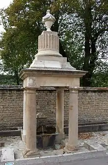
The commune has a number of buildings and sites that are registered as historical monuments:
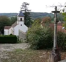
Religious heritage
The commune has several religious buildings and sites that are registered as historical monuments:
- A Benedictine Priory (1502)
 [20]
[20] - The Parish Church of Saint Martin (15th century)[21]
The Church contains a large number of items that are registered as historical objects. For a complete list including links to descriptions (in French) click here.
See also
References
- "Répertoire national des élus: les maires". data.gouv.fr, Plateforme ouverte des données publiques françaises (in French). 2 December 2020. Retrieved 8 December 2020.
- "Populations légales 2017". INSEE. Retrieved 6 January 2020.
- Baulme-la-Roche on Lion1906
- Inhabitants of Côte-d'Or (in French)
- Baulme-la-Roche on Google Maps
- Baulme-la-Roche on the Géoportail from National Geographic Institute (IGN) website (in French)
- Beaume la Roche on the 1750 Cassini Map
- Beaume la Roche on the 1790 Cassini Map
- List of Mayors of France (in French)
- Des villages de Cassini aux communes d'aujourd'hui: Commune data sheet Baulme-la-Roche, EHESS. (in French)
- Population en historique depuis 1968, INSEE
- Ministry of Culture, Mérimée IA00059737 Farmhouse (in French)
- Ministry of Culture, Mérimée IA00059736 House (in French)
- Ministry of Culture, Mérimée IA00059859 Farmhouse (in French)
- Ministry of Culture, Mérimée IA00059740 House (in French)
- Ministry of Culture, Mérimée IA00059742 Blacksmith's House (in French)
- Ministry of Culture, Mérimée PA00112097 Fountain (in French)
- Ministry of Culture, Mérimée IA00059858 Houses and farms (in French)
- Ministry of Culture, Mérimée IA00059782 Fountain (in French)
- Ministry of Culture, Mérimée IA00059782 PA21000008 Benedictine Priory
 (in French)
 - Ministry of Culture, Mérimée IA00059738 IA00059739 Parish Church of Saint Martin (in French)
| Wikimedia Commons has media related to Baulme-la-Roche. |
| Authority control |
|---|