Auvillars-sur-Saône
Auvillars-sur-Saône is a commune in the Côte-d'Or department in the Bourgogne-Franche-Comté region of eastern France.
Auvillars-sur-Saône | |
|---|---|
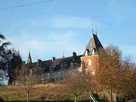 The Castle | |
.svg.png.webp) Coat of arms | |
Location of Auvillars-sur-Saône 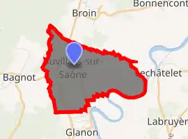
| |
 Auvillars-sur-Saône  Auvillars-sur-Saône | |
| Coordinates: 47°03′47″N 5°06′11″E | |
| Country | France |
| Region | Bourgogne-Franche-Comté |
| Department | Côte-d'Or |
| Arrondissement | Beaune |
| Canton | Brazey-en-Plaine |
| Intercommunality | CC Rives Saône |
| Government | |
| • Mayor (2014-2020) | Marc Jaudaux |
| Area 1 | 6.74 km2 (2.60 sq mi) |
| Population (2017-01-01)[1] | 331 |
| • Density | 49/km2 (130/sq mi) |
| Time zone | UTC+01:00 (CET) |
| • Summer (DST) | UTC+02:00 (CEST) |
| INSEE/Postal code | 21035 /21250 |
| Elevation | 176–226 m (577–741 ft) (avg. 231 m or 758 ft) |
| 1 French Land Register data, which excludes lakes, ponds, glaciers > 1 km2 (0.386 sq mi or 247 acres) and river estuaries. | |
The inhabitants of the commune are known as Auvillerois or Auvilleroises.[2]
Geography
Auvillars-sur-Saône is located some 14 km south-east of Nuits-Saint-Georges and 20 km east by north-east of Beaune. Access to the commune is by the D996 road from Corcelles-lès-Cîteaux in the north which passes south down the western side of the commune to Pouilly-sur-Saône. The D35A branches off the D996 in the commune and goes to the village then continues south to Glanon. The D20 branches west off the D996 and goes to Bagnot. Apart from the village there is the hamlet of Auvillars in the south. Apart from patches of forest in the centre of the commune the land is all farmland.[3]
The Saône river forms the eastern boundary of the commune as it flows south to eventually join the Rhône at Lyon. The Raie du Lac flows south through the centre of the commune to join the Saône.[3]
Neighbouring communes and villages
Places adjacent to Auvillars-sur-Saône | ||||||||||
|---|---|---|---|---|---|---|---|---|---|---|
| ||||||||||
History
The Chateau was built in 1409 by Jean de Saint-Hilaire and damaged in 1636 by the troops of Matthias Gallas.
Heraldry
Arms of Auvillars-sur-Saône |
Blazon: Or, a fesse wavy of Azure abased between an eagle in chief of sable and in base two boar heads erased the same surmounted by a mullet of 6 points in Gules; in chief Azure with two cinquefoils of Or. |
Administration
List of Successive Mayors[4]
| From | To | Name | Party | Position |
|---|---|---|---|---|
| 2001 | 2014 | Georges Louis Henry | ||
| 2014 | 2020 | Marc Jaudaux |
(Not all data is known)
Demography
In 2017 the commune had 331 inhabitants.
|
| ||||||||||||||||||||||||||||||||||||||||||||||||||||||||||||||||||||||||||||||||||||||||||||||||||||||||||||||||||
| Source: EHESS[5] and INSEE[6] | |||||||||||||||||||||||||||||||||||||||||||||||||||||||||||||||||||||||||||||||||||||||||||||||||||||||||||||||||||
Culture and heritage
Civil heritage
The commune has a number of buildings and structures that are registered as historical monuments:
- A Lavoir (Public laundry) (19th century)
 [7]
[7] - A Farmhouse at CR 11 (19th century)[8]
- A Manor House at CR 14 (18th century)[9]
- A Farmhouse at CR 21 (19th century)[10]
- A School at CR 21 (1876)[11]
- The Town Hall at CR 21 (19th century)[12]
- A Farmhouse at CR 4 (18th century)[13]
- A Farmhouse at Rue Corné (18th century)[14]
- A Farmhouse at Rue des Creux (1817)[15]
- A Farmhouse at Rue du Creux Bâton (1) (18th century)[16]
- A Farmhouse at Rue du Creux Bâton (2) (18th century)[17]
- A Well at Rue du Creux Bâton (19th century)[18]
- A Fortified Chateau at Rue de l'Eglise (1681)[19]
- A Farmhouse at RD 996 (18th century)[20]
- A Manor House at Rue du Tertre (19th century)[21]
- Houses and Farms (18th - 19th century)[22]
There is a house in the commune that has 2 Weathervanes (18th century)![]() that are registered as historical objects.[23]
that are registered as historical objects.[23]
Religious heritage
The commune has several religious buildings and structures that are registered as historical monuments:
- A Presbytery at Rue de l'Eglise (19th century)[24]
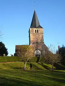
- The Parish Church of Sainte-Madeleine at Rue de l'Eglise (15th century)[25][26] The Church has a very large number of items that are registered as historical objects. Click here for a complete list with links to more details. (in French)
- A Wayside Coss at RD 35a (1901)[27]
- An Oratory at RD 996 (16th century)[28]
- A Cemetery Cross (1844)[29]
Environmental heritage
Because of its efforts for the quality of its nocturnal environment the commune was labeled a "2 star Village" in 2013.[30] The label is awarded by the National Association for the Protection of the sky and night environment (ANPCEN ) and has 5 levels. A panel displayed at the entrances to the village shows this distinction.
See also
References
- "Populations légales 2017". INSEE. Retrieved 6 January 2020.
- Inhabitants of Côte-d'Or (in French)
- Google Maps
- List of Mayors of France (in French)
- Des villages de Cassini aux communes d'aujourd'hui: Commune data sheet Auvillars-sur-Saône, EHESS. (in French)
- Population en historique depuis 1968, INSEE
- Ministry of Culture, Mérimée IA00070869 Lavoir (in French)
- Ministry of Culture, Mérimée IA00070860 Farm at CR 11 (in French)
- Ministry of Culture, Mérimée IA00070858 Manor House at CR 14 (in French)
- Ministry of Culture, Mérimée IA00070861 Farm at CR 21 (in French)
- Ministry of Culture, Mérimée IA00070855 School at CR 21 (in French)
- Ministry of Culture, Mérimée IA00070854 Town Hall at CR 21 (in French)
- Ministry of Culture, Mérimée IA00070862 Farm at CR 4 (in French)
- Ministry of Culture, Mérimée IA00070863 Farm at Rue Corné (in French)
- Ministry of Culture, Mérimée IA00070864 Farm at Rue des Creux (in French)
- Ministry of Culture, Mérimée IA00070865 Farmhouse 1 at Rue du Creux Bâton (in French)
- Ministry of Culture, Mérimée IA00070866 Farmhouse 2 at Rue du Creux Bâton (in French)
- Ministry of Culture, Mérimée IA00070870 Well at Rue du Creux Bâton (in French)
- Ministry of Culture, Mérimée IA00070856 Fortified Chateau at Rue de l'Eglise (in French)
- Ministry of Culture, Mérimée IA00070867 Farmhouse at RD 996 (in French)
- Ministry of Culture, Mérimée IA00070859 Manor House at Rue du Tertre (in French)
- Ministry of Culture, Mérimée IA00070852 Houses and Farms (in French)
- Ministry of Culture, Palissy IM21000058 Weathervane (in French)
- Ministry of Culture, Mérimée IA00070857 Presbytery (in French)
- Ministry of Culture, Mérimée IA00070853 Parish Church of Saint-Madelaine (in French)
- Ministry of Culture, Mérimée PA00112076 Parish Church of Saint-Madelaine (in French)

- Ministry of Culture, Mérimée IA00070872 Wayside Cross at RD 35a (in French)
- Ministry of Culture, Mérimée IA00070871 Oratory at RD 996 (in French)
- Ministry of Culture, Mérimée IA00070868 Cemetery Cross (in French)
- Rain of stars on Côte d'Or article on Le Bien Public website, 19 February 2014. (in French)
External links
- Auvillars-sur-Saône on Lion1906
- Auvillars-sur-Saône on Géoportail, National Geographic Institute (IGN) website (in French)
- Auvillars on the 1750 Cassini Map
| Wikimedia Commons has media related to Auvillars-sur-Saône. |
| Authority control |
|---|