Pouilly-en-Auxois
Pouilly-en-Auxois is a commune in the Côte-d'Or department in eastern France.
Pouilly-en-Auxois | |
|---|---|
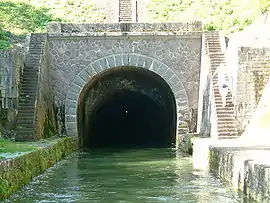 Canal of Burgundy tunnel | |
.svg.png.webp) Coat of arms | |
Location of Pouilly-en-Auxois 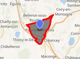
| |
 Pouilly-en-Auxois  Pouilly-en-Auxois | |
| Coordinates: 47°15′48″N 4°33′23″E | |
| Country | France |
| Region | Bourgogne-Franche-Comté |
| Department | Côte-d'Or |
| Arrondissement | Beaune |
| Canton | Arnay-le-Duc |
| Government | |
| • Mayor (2020–2026) | Éric Piesvaux |
| Area 1 | 10.12 km2 (3.91 sq mi) |
| Population (2017-01-01)[1] | 1,481 |
| • Density | 150/km2 (380/sq mi) |
| Time zone | UTC+01:00 (CET) |
| • Summer (DST) | UTC+02:00 (CEST) |
| INSEE/Postal code | 21501 /21320 |
| Elevation | 369–560 m (1,211–1,837 ft) (avg. 384 m or 1,260 ft) |
| 1 French Land Register data, which excludes lakes, ponds, glaciers > 1 km2 (0.386 sq mi or 247 acres) and river estuaries. | |
It is the start of the Canal of Burgundy, which passes in a tunnel under the town.
Geography
The town was originally sited on the St Pierre hilltop surrounding a (now vanished) castle and walls built by the Dukes of Burgundy and the 13th/14th century Chapelle de Notre Dame Trouvée (Chapel of Our Lady Found). Beginning in the 16th century the town was rebuilt further down in the valley and in 1868 the new St Pierre church was built in what is now the city center.
Population
| Year | Pop. | ±% |
|---|---|---|
| 1962 | 1,046 | — |
| 1968 | 1,136 | +8.6% |
| 1975 | 1,198 | +5.5% |
| 1982 | 1,396 | +16.5% |
| 1990 | 1,372 | −1.7% |
| 1999 | 1,496 | +9.0% |
| 2008 | 1,507 | +0.7% |
Economy
From the twelfth century, the town was a regional agricultural center, specializing in wheat and later hemp, oils, skins, wool and sheep.
Sights
The town features an unusual tower called "The Dove Cote", dating from the fifteenth century, the interior walls of which contain 1200 pigeon holes.
See also
References
- "Populations légales 2017". INSEE. Retrieved 6 January 2020.
| Wikimedia Commons has media related to Pouilly-en-Auxois. |
| Authority control |
|
|---|