Auris, Isère
Auris is a commune in the Isère department in the Auvergne-Rhône-Alpes region of south-eastern France.
Auris | |
|---|---|
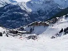
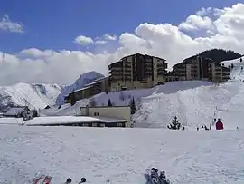 The Auris-en-Oisans Ski Station | |
Location of Auris 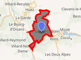
| |
 Auris  Auris | |
| Coordinates: 45°02′50″N 6°05′15″E | |
| Country | France |
| Region | Auvergne-Rhône-Alpes |
| Department | Isère |
| Arrondissement | Grenoble |
| Canton | Oisans-Romanche |
| Intercommunality | CC Oisans |
| Government | |
| • Mayor (2014-2020) | Yves Moiroux |
| Area 1 | 11 km2 (4 sq mi) |
| Population (2017-01-01)[1] | 190 |
| • Density | 17/km2 (45/sq mi) |
| Time zone | UTC+01:00 (CET) |
| • Summer (DST) | UTC+02:00 (CEST) |
| INSEE/Postal code | 38020 /38142 |
| Elevation | 720–2,164 m (2,362–7,100 ft) (avg. 1,240 m or 4,070 ft) |
| 1 French Land Register data, which excludes lakes, ponds, glaciers > 1 km2 (0.386 sq mi or 247 acres) and river estuaries. | |
The inhabitants of the commune are known as Aurienchons or Aurienchonnes.[2]
Geography
Auris is an alpine commune some 30 km south-east of Grenoble and 5 km west of Mont-de-Lans. Access to the commune is by the D211A road from La Garde in the west which passes through the commune by a tortuous route and continues east to Le Freney-d'Oisans. The D211E branches off the D211A in the commune to go to La Grand Combe. Apart from the village (which is solely the town hall) there is the hamlet of Les Cours to the north and Le Cert and Les Chatains to the south. The commune is rugged with alpine terrain and a large forest to the west of the village (La Forêt).[3]
The Romanche river forms the southern border of the commune as it flows west to the Barrage du Clapier - an artificial lake on the southern border of the commune - then continues west then north to eventually join the Drac at Jarrie. The Venéon river flows from the south through the south-western extension of the commune to join the Romanche there.[3]
Neighbouring communes and villages
Places adjacent to Auris, Isère | |
|---|---|
Toponymy
The commune is sometimes informally called Auris-en-Oisans.
Administration
List of Successive Mayors[4]
| From | To | Name | Party | Position |
|---|---|---|---|---|
| 2001 | 2007 | Lucien Ponce | ||
| 2007 | 2014 | Jean Luc Pellorce | ||
| 2014 | 2020 | Yves Moiroux |
(Not all data is known)
Demography
In 2017 the commune had 190 inhabitants.
|
| ||||||||||||||||||||||||||||||||||||||||||||||||||||||||||||||||||||||||||||||||||||||||||||||||||||||||||||||||||
| Source: EHESS[5] and INSEE[6] | |||||||||||||||||||||||||||||||||||||||||||||||||||||||||||||||||||||||||||||||||||||||||||||||||||||||||||||||||||
Culture and heritage
Civil heritage
- A Roman bridge
- The Rural Museum
See also
References
- "Populations légales 2017". INSEE. Retrieved 6 January 2020.
- Inhabitants of Isère (in French)
- Google Maps
- List of Mayors of France (in French)
- Des villages de Cassini aux communes d'aujourd'hui: Commune data sheet Auris, EHESS. (in French)
- Population en historique depuis 1968, INSEE
- Ministry of Culture, Palissy PM38000010 2 Candlesticks on the main Altar (in French)

- Ministry of Culture, Palissy PM38000009 Hand Bell (in French)
- Ministry of Culture, Palissy PM38000008 Altar and Retable (in French)
External links
- Auris on Lion1906
- Auris on Géoportail, National Geographic Institute (IGN) website (in French)
- Auris en Oysans on the 1750 Cassini Map
| Wikimedia Commons has media related to Auris. |
| Authority control |
|---|