Saint-Pierre-de-Bressieux
Saint-Pierre-de-Bressieux is a commune in the Isère department in southeastern France.
Saint-Pierre-de-Bressieux | |
|---|---|
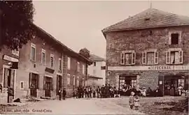 Saint-Pierre-de-Bressieux at the start of the 20th century | |
Location of Saint-Pierre-de-Bressieux 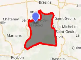
| |
 Saint-Pierre-de-Bressieux  Saint-Pierre-de-Bressieux | |
| Coordinates: 45°18′58″N 5°17′10″E | |
| Country | France |
| Region | Auvergne-Rhône-Alpes |
| Department | Isère |
| Arrondissement | Vienne |
| Canton | Bièvre |
| Intercommunality | Bièvre Toutes Aures |
| Government | |
| • Mayor (2014–2020) | Jean-Marc Falissard |
| Area 1 | 23.08 km2 (8.91 sq mi) |
| Population (2017-01-01)[1] | 761 |
| • Density | 33/km2 (85/sq mi) |
| Time zone | UTC+01:00 (CET) |
| • Summer (DST) | UTC+02:00 (CEST) |
| INSEE/Postal code | 38440 /38870 |
| Elevation | 378–723 m (1,240–2,372 ft) (avg. 430 m or 1,410 ft) |
| 1 French Land Register data, which excludes lakes, ponds, glaciers > 1 km2 (0.386 sq mi or 247 acres) and river estuaries. | |
Geography
The Galaure forms part of the commune's southern border.
Population
| Year | Pop. | ±% |
|---|---|---|
| 1800 | 1,186 | — |
| 1806 | 1,206 | +1.7% |
| 1821 | 1,237 | +2.6% |
| 1831 | 1,339 | +8.2% |
| 1841 | 1,331 | −0.6% |
| 1851 | 1,396 | +4.9% |
| 1861 | 1,245 | −10.8% |
| 1872 | 1,243 | −0.2% |
| 1881 | 1,146 | −7.8% |
| 1891 | 1,056 | −7.9% |
| 1901 | 929 | −12.0% |
| 1911 | 883 | −5.0% |
| 1921 | 812 | −8.0% |
| 1831 | 684 | −15.8% |
| 1946 | 619 | −9.5% |
| 1954 | 613 | −1.0% |
| 1962 | 562 | −8.3% |
| 1968 | 543 | −3.4% |
| 1975 | 508 | −6.4% |
| 1982 | 592 | +16.5% |
| 1990 | 621 | +4.9% |
| 1999 | 627 | +1.0% |
| 2006 | 674 | +7.5% |
| 2011 | 709 | +5.2% |
See also
References
| Wikimedia Commons has media related to Saint-Pierre-de-Bressieux. |
- "Populations légales 2017". INSEE. Retrieved 6 January 2020.
| Authority control |
|---|
This article is issued from Wikipedia. The text is licensed under Creative Commons - Attribution - Sharealike. Additional terms may apply for the media files.