Saint-André-le-Gaz
Saint-André-le-Gaz is a commune in the Isère department in southeastern France.
Saint-André-le-Gaz | |
|---|---|
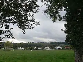 A general view of Saint-André-le-Gaz | |
Location of Saint-André-le-Gaz 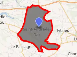
| |
 Saint-André-le-Gaz  Saint-André-le-Gaz | |
| Coordinates: 45°32′59″N 5°32′06″E | |
| Country | France |
| Region | Auvergne-Rhône-Alpes |
| Department | Isère |
| Arrondissement | La Tour-du-Pin |
| Canton | La Tour-du-Pin |
| Intercommunality | Bourbre-Tisserands |
| Government | |
| • Mayor (2014–2020) | Magali Guillot |
| Area 1 | 8.89 km2 (3.43 sq mi) |
| Population (2017-01-01)[1] | 2,793 |
| • Density | 310/km2 (810/sq mi) |
| Time zone | UTC+01:00 (CET) |
| • Summer (DST) | UTC+02:00 (CEST) |
| INSEE/Postal code | 38357 /38490 |
| Elevation | 356–488 m (1,168–1,601 ft) (avg. 409 m or 1,342 ft) |
| 1 French Land Register data, which excludes lakes, ponds, glaciers > 1 km2 (0.386 sq mi or 247 acres) and river estuaries. | |
Geography
The Bourbre forms the commune's eastern border.
Population
| Year | Pop. | ±% |
|---|---|---|
| 1793 | 906 | — |
| 1806 | 987 | +8.9% |
| 1821 | 970 | −1.7% |
| 1831 | 1,144 | +17.9% |
| 1841 | 1,396 | +22.0% |
| 1851 | 1,342 | −3.9% |
| 1861 | 1,287 | −4.1% |
| 1872 | 1,370 | +6.4% |
| 1881 | 1,459 | +6.5% |
| 1891 | 1,393 | −4.5% |
| 1901 | 1,334 | −4.2% |
| 1911 | 1,269 | −4.9% |
| 1921 | 119 | −90.6% |
| 1931 | 1,305 | +996.6% |
| 1946 | 1,160 | −11.1% |
| 1954 | 1,240 | +6.9% |
| 1962 | 1,311 | +5.7% |
| 1968 | 1,406 | +7.2% |
| 1975 | 1,526 | +8.5% |
| 1982 | 1,641 | +7.5% |
| 1990 | 1,903 | +16.0% |
| 1999 | 1,961 | +3.0% |
| 2006 | 2,291 | +16.8% |
| 2011 | 2,530 | +10.4% |
| 2014 | 2,751 | +8.7% |
See also
References
- "Populations légales 2017". INSEE. Retrieved 6 January 2020.
| Wikimedia Commons has media related to Saint-André-le-Gaz. |
| Authority control |
|---|
This article is issued from Wikipedia. The text is licensed under Creative Commons - Attribution - Sharealike. Additional terms may apply for the media files.