Avignonet
Avignonet is a commune in the Isère department in the Auvergne-Rhône-Alpes region of south-eastern France.
Avignonet | |
|---|---|
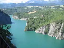 Monteynard Lake on the border with Monteynard | |
Location of Avignonet 
| |
 Avignonet  Avignonet | |
| Coordinates: 44°57′35″N 5°39′28″E | |
| Country | France |
| Region | Auvergne-Rhône-Alpes |
| Department | Isère |
| Arrondissement | Grenoble |
| Canton | Matheysine-Trièves |
| Intercommunality | CC Trièves |
| Government | |
| • Mayor (2014-2020) | Jérôme Fauconnier |
| Area 1 | 8 km2 (3 sq mi) |
| Population (2017-01-01)[1] | 197 |
| • Density | 25/km2 (64/sq mi) |
| Time zone | UTC+01:00 (CET) |
| • Summer (DST) | UTC+02:00 (CEST) |
| INSEE/Postal code | 38023 /38650 |
| Elevation | 362–825 m (1,188–2,707 ft) |
| 1 French Land Register data, which excludes lakes, ponds, glaciers > 1 km2 (0.386 sq mi or 247 acres) and river estuaries. | |
The inhabitants of the commune are known as Avignonetins or Avignonetines.[2]
Geography
Avignonet is located some 25 km south of Grenoble and 8 km north of Monestier-de-Clermont. Access to the commune is by the A51 autoroute (E712) which passes south through the western arm of the commune and has Exit ![]() 13 Sinard on the commune border. Access to the village is by road D110A from Saint-Martin-de-la-Cluze in the north which comes down the western border of the commune to the village. The D110C goes east from Sinard to the dam through the south of the commune. Apart from the village there are the hamlets of Le Cros and Le Mas in the south-east. There are large forests in the east of the commune with the rest of the commune farmland.[3]
13 Sinard on the commune border. Access to the village is by road D110A from Saint-Martin-de-la-Cluze in the north which comes down the western border of the commune to the village. The D110C goes east from Sinard to the dam through the south of the commune. Apart from the village there are the hamlets of Le Cros and Le Mas in the south-east. There are large forests in the east of the commune with the rest of the commune farmland.[3]
The eastern border of the commune is entirely formed by the Drac river and the large artificial Monteynard lake formed by the dam on the Drac river. Several streams rise in the commune and flow east to the lake including the Ruisseau d'Aiguettas, the Ruisseau de Mitraire, the Ruisseau de la Proche, and the Ruisseau des Vaux which forms part of the northern border.[3]
Neighbouring communes and villages
Places adjacent to Avignonet | |
|---|---|
Administration
List of Successive Mayors[4]
| From | To | Name | Party | Position |
|---|---|---|---|---|
| 2001 | 2007 | Camille Chatelard | ||
| 2007 | 2020 | Jérôme Fauconnier |
(Not all data is known)
Demography
In 2017 the commune had 197 inhabitants. In 1962 its population peaked at 951, which was due to construction workers for the Lac de Monteynard-Avignonet reservoir.[5]
|
| ||||||||||||||||||||||||||||||||||||||||||||||||||||||||||||||||||||||||||||||||||||||||||||||||||||||||||||||||||
| Source: EHESS[6] and INSEE[7] | |||||||||||||||||||||||||||||||||||||||||||||||||||||||||||||||||||||||||||||||||||||||||||||||||||||||||||||||||||
Culture and heritage

Civil heritage
- The Lac de Monteynard-Avignonet with its Dam and Hydro-electricity plant.
- Ruins of the Chateau d'Ars
- The Chateau des marceaux from the 17th century
- Former Chateaux
- Chateau La Cluse
- Chateau des seigneurs du Gua
 View from the lake
 Escarpment on the lake
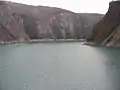 View of the lake
 The view east from the lake
.jpg.webp)
See also
References
- "Populations légales 2017". INSEE. Retrieved 6 January 2020.
- Inhabitants of Isère (in French)
- Google Maps
- List of Mayors of France (in French)
- C. Marie (1963). "Premier bilan du recensement de 1962 dans le département de l'Isère". Revue de Géographie Alpine. 51 (2): 292–293.
- Des villages de Cassini aux communes d'aujourd'hui: Commune data sheet Avignonet, EHESS. (in French)
- Population en historique depuis 1968, INSEE
External links
- Photos of Avignonet (in French)
- Bell Towers website (in French)
- Avignonet on Lion1906
- Avignonet on Géoportail, National Geographic Institute (IGN) website (in French)
- Avignonet on the 1750 Cassini Map
| Wikimedia Commons has media related to Avignonet. |
| Authority control |
|---|