Azay-sur-Cher
Azay-sur-Cher is a commune in the Indre-et-Loire department in central France.
Azay-sur-Cher | |
|---|---|
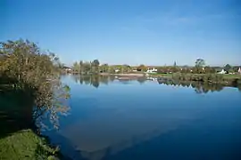 The Cher river in Azay-sur-Cher | |
.svg.png.webp) Coat of arms | |
Location of Azay-sur-Cher 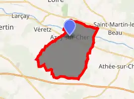
| |
 Azay-sur-Cher  Azay-sur-Cher | |
| Coordinates: 47°21′00″N 0°50′49″E | |
| Country | France |
| Region | Centre-Val de Loire |
| Department | Indre-et-Loire |
| Arrondissement | Tours |
| Canton | Bléré |
| Intercommunality | CC Touraine-Est Vallées |
| Government | |
| • Mayor (2014-2020) | Janick Alary |
| Area 1 | 22.85 km2 (8.82 sq mi) |
| Population (2017-01-01)[1] | 3,082 |
| • Density | 130/km2 (350/sq mi) |
| Time zone | UTC+01:00 (CET) |
| • Summer (DST) | UTC+02:00 (CEST) |
| INSEE/Postal code | 37015 /37270 |
| Elevation | 48–103 m (157–338 ft) |
| 1 French Land Register data, which excludes lakes, ponds, glaciers > 1 km2 (0.386 sq mi or 247 acres) and river estuaries. | |
Population
| Year | Pop. | ±% |
|---|---|---|
| 1793 | 1,315 | — |
| 1800 | 1,153 | −12.3% |
| 1806 | 1,201 | +4.2% |
| 1821 | 1,209 | +0.7% |
| 1831 | 1,355 | +12.1% |
| 1836 | 1,296 | −4.4% |
| 1841 | 1,262 | −2.6% |
| 1846 | 1,223 | −3.1% |
| 1851 | 1,289 | +5.4% |
| 1856 | 1,301 | +0.9% |
| 1861 | 1,307 | +0.5% |
| 1866 | 1,317 | +0.8% |
| 1872 | 1,250 | −5.1% |
| 1876 | 1,260 | +0.8% |
| 1881 | 1,324 | +5.1% |
| 1886 | 1,331 | +0.5% |
| 1891 | 1,206 | −9.4% |
| 1896 | 1,107 | −8.2% |
| 1901 | 1,114 | +0.6% |
| 1906 | 1,125 | +1.0% |
| 1911 | 1,111 | −1.2% |
| 1921 | 1,089 | −2.0% |
| 1926 | 1,116 | +2.5% |
| 1931 | 1,052 | −5.7% |
| 1936 | 1,077 | +2.4% |
| 1946 | 1,131 | +5.0% |
| 1954 | 1,144 | +1.1% |
| 1962 | 1,150 | +0.5% |
| 1968 | 1,194 | +3.8% |
| 1975 | 1,375 | +15.2% |
| 1982 | 1,830 | +33.1% |
| 1990 | 2,408 | +31.6% |
| 1999 | 2,704 | +12.3% |
| 2006 | 2,878 | +6.4% |
| 2009 | 2,989 | +3.9% |
| 2014 | 3,051 | +2.1% |
References
- "Populations légales 2017". INSEE. Retrieved 6 January 2020.
| Wikimedia Commons has media related to Azay-sur-Cher. |
| Authority control |
|---|
This article is issued from Wikipedia. The text is licensed under Creative Commons - Attribution - Sharealike. Additional terms may apply for the media files.