Genillé
Genillé is a commune in the Indre-et-Loire department in central France.
Genillé | |
|---|---|
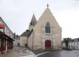 The church of Sainte-Eulalie, in Genillé | |
.svg.png.webp) Coat of arms | |
Location of Genillé 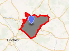
| |
 Genillé  Genillé | |
| Coordinates: 47°11′11″N 1°05′46″E | |
| Country | France |
| Region | Centre-Val de Loire |
| Department | Indre-et-Loire |
| Arrondissement | Loches |
| Canton | Loches |
| Intercommunality | CC Loches Sud Touraine |
| Government | |
| • Mayor (2008–2014) | Jacques Herbert |
| Area 1 | 63.12 km2 (24.37 sq mi) |
| Population (2017-01-01)[1] | 1,521 |
| • Density | 24/km2 (62/sq mi) |
| Time zone | UTC+01:00 (CET) |
| • Summer (DST) | UTC+02:00 (CEST) |
| INSEE/Postal code | 37111 /37460 |
| Elevation | 71–144 m (233–472 ft) |
| 1 French Land Register data, which excludes lakes, ponds, glaciers > 1 km2 (0.386 sq mi or 247 acres) and river estuaries. | |
Geography
The village lies in the middle of the commune, on the right bank of the Indrois, which flows northwest through the middle of the commune and forms parts of its eastern and western borders.
Population
| Year | Pop. | ±% |
|---|---|---|
| 1793 | 1,850 | — |
| 1800 | 1,942 | +5.0% |
| 1806 | 1,916 | −1.3% |
| 1821 | 1,988 | +3.8% |
| 1831 | 1,954 | −1.7% |
| 1836 | 1,943 | −0.6% |
| 1841 | 1,912 | −1.6% |
| 1846 | 2,008 | +5.0% |
| 1851 | 2,063 | +2.7% |
| 1856 | 2,006 | −2.8% |
| 1861 | 2,043 | +1.8% |
| 1866 | 2,130 | +4.3% |
| 1872 | 2,087 | −2.0% |
| 1876 | 2,242 | +7.4% |
| 1881 | 2,276 | +1.5% |
| 1886 | 2,433 | +6.9% |
| 1891 | 2,325 | −4.4% |
| 1896 | 2,202 | −5.3% |
| 1901 | 2,132 | −3.2% |
| 1906 | 2,097 | −1.6% |
| 1911 | 2,017 | −3.8% |
| 1921 | 1,772 | −12.1% |
| 1926 | 1,850 | +4.4% |
| 1931 | 1,718 | −7.1% |
| 1936 | 1,665 | −3.1% |
| 1946 | 1,737 | +4.3% |
| 1954 | 1,647 | −5.2% |
| 1962 | 1,559 | −5.3% |
| 1968 | 1,585 | +1.7% |
| 1975 | 1,417 | −10.6% |
| 1982 | 1,413 | −0.3% |
| 1990 | 1,428 | +1.1% |
| 1999 | 1,425 | −0.2% |
| 2006 | 1,507 | +5.8% |
| 2009 | 1,554 | +3.1% |
References
- "Populations légales 2017". INSEE. Retrieved 6 January 2020.
| Wikimedia Commons has media related to Genillé. |
| Authority control |
|
|---|
This article is issued from Wikipedia. The text is licensed under Creative Commons - Attribution - Sharealike. Additional terms may apply for the media files.