Saint-Quentin-sur-Indrois
Saint-Quentin-sur-Indrois is a commune in the Indre-et-Loire department in central France.
Saint-Quentin-sur-Indrois | |
|---|---|
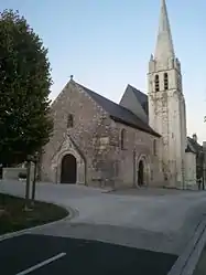 The church of Saint-Quentin, in Saint-Quentin-sur-Indrois | |
Location of Saint-Quentin-sur-Indrois 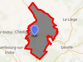
| |
 Saint-Quentin-sur-Indrois  Saint-Quentin-sur-Indrois | |
| Coordinates: 47°12′15″N 1°01′28″E | |
| Country | France |
| Region | Centre-Val de Loire |
| Department | Indre-et-Loire |
| Arrondissement | Loches |
| Canton | Loches |
| Intercommunality | CC Loches Sud Touraine |
| Government | |
| • Mayor (2008–2014) | Pascal Boucher |
| Area 1 | 27.23 km2 (10.51 sq mi) |
| Population (2017-01-01)[1] | 510 |
| • Density | 19/km2 (49/sq mi) |
| Time zone | UTC+01:00 (CET) |
| • Summer (DST) | UTC+02:00 (CEST) |
| INSEE/Postal code | 37234 /37310 |
| Elevation | 65–127 m (213–417 ft) |
| 1 French Land Register data, which excludes lakes, ponds, glaciers > 1 km2 (0.386 sq mi or 247 acres) and river estuaries. | |
Geography
The village lies in the middle of the commune, on the right bank of the Indrois, which flows west through the middle of the commune.
Population
| Year | Pop. | ±% |
|---|---|---|
| 1793 | 541 | — |
| 1800 | 591 | +9.2% |
| 1806 | 844 | +42.8% |
| 1821 | 550 | −34.8% |
| 1831 | 623 | +13.3% |
| 1836 | 689 | +10.6% |
| 1841 | 723 | +4.9% |
| 1846 | 720 | −0.4% |
| 1851 | 679 | −5.7% |
| 1856 | 660 | −2.8% |
| 1861 | 673 | +2.0% |
| 1866 | 674 | +0.1% |
| 1872 | 654 | −3.0% |
| 1876 | 702 | +7.3% |
| 1881 | 708 | +0.9% |
| 1886 | 649 | −8.3% |
| 1891 | 656 | +1.1% |
| 1896 | 598 | −8.8% |
| 1901 | 601 | +0.5% |
| 1906 | 586 | −2.5% |
| 1911 | 611 | +4.3% |
| 1921 | 553 | −9.5% |
| 1926 | 536 | −3.1% |
| 1931 | 548 | +2.2% |
| 1936 | 565 | +3.1% |
| 1946 | 569 | +0.7% |
| 1954 | 638 | +12.1% |
| 1962 | 523 | −18.0% |
| 1968 | 440 | −15.9% |
| 1975 | 373 | −15.2% |
| 1982 | 425 | +13.9% |
| 1990 | 405 | −4.7% |
| 1999 | 429 | +5.9% |
| 2006 | 429 | +0.0% |
| 2009 | 470 | +9.6% |
References
- "Populations légales 2017". INSEE. Retrieved 6 January 2020.
| Wikimedia Commons has media related to Saint-Quentin-sur-Indrois. |
| Authority control |
|---|
This article is issued from Wikipedia. The text is licensed under Creative Commons - Attribution - Sharealike. Additional terms may apply for the media files.