Sainte-Maure-de-Touraine
Sainte-Maure-de-Touraine (French pronunciation: [sɛ̃t moʁ də tuʁɛn] (![]() listen), literally Sainte Maure of Touraine) is a commune in the Indre-et-Loire department in central France.
listen), literally Sainte Maure of Touraine) is a commune in the Indre-et-Loire department in central France.
Sainte-Maure-de-Touraine | |
|---|---|
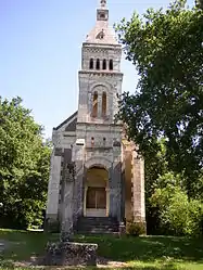 The Chapel of the Virgin | |
.svg.png.webp) Coat of arms | |
Location of Sainte-Maure-de-Touraine 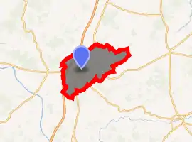
| |
 Sainte-Maure-de-Touraine  Sainte-Maure-de-Touraine | |
| Coordinates: 47°06′47″N 0°37′19″E | |
| Country | France |
| Region | Centre-Val de Loire |
| Department | Indre-et-Loire |
| Arrondissement | Chinon |
| Canton | Sainte-Maure-de-Touraine |
| Government | |
| • Mayor (2020–2026) | Michel Champigny |
| Area 1 | 40.41 km2 (15.60 sq mi) |
| Population (2017-01-01)[1] | 4,214 |
| • Density | 100/km2 (270/sq mi) |
| Time zone | UTC+01:00 (CET) |
| • Summer (DST) | UTC+02:00 (CEST) |
| INSEE/Postal code | 37226 /37800 |
| Elevation | 58–122 m (190–400 ft) |
| 1 French Land Register data, which excludes lakes, ponds, glaciers > 1 km2 (0.386 sq mi or 247 acres) and river estuaries. | |
Population
| Year | Pop. | ±% |
|---|---|---|
| 1793 | 2,230 | — |
| 1800 | 2,179 | −2.3% |
| 1806 | 2,108 | −3.3% |
| 1821 | 2,253 | +6.9% |
| 1831 | 2,259 | +0.3% |
| 1836 | 2,534 | +12.2% |
| 1841 | 2,602 | +2.7% |
| 1846 | 2,701 | +3.8% |
| 1851 | 2,744 | +1.6% |
| 1856 | 2,678 | −2.4% |
| 1861 | 2,595 | −3.1% |
| 1866 | 2,603 | +0.3% |
| 1872 | 2,409 | −7.5% |
| 1876 | 2,318 | −3.8% |
| 1881 | 2,462 | +6.2% |
| 1886 | 2,547 | +3.5% |
| 1891 | 2,602 | +2.2% |
| 1896 | 2,518 | −3.2% |
| 1901 | 2,612 | +3.7% |
| 1906 | 2,529 | −3.2% |
| 1911 | 2,527 | −0.1% |
| 1921 | 2,355 | −6.8% |
| 1926 | 2,384 | +1.2% |
| 1931 | 2,374 | −0.4% |
| 1936 | 2,537 | +6.9% |
| 1946 | 2,743 | +8.1% |
| 1954 | 2,740 | −0.1% |
| 1962 | 3,069 | +12.0% |
| 1968 | 3,574 | +16.5% |
| 1975 | 4,016 | +12.4% |
| 1982 | 4,130 | +2.8% |
| 1990 | 3,983 | −3.6% |
| 1999 | 3,909 | −1.9% |
| 2006 | 3,995 | +2.2% |
| 2009 | 4,072 | +1.9% |
References
- "Populations légales 2017". INSEE. Retrieved 6 January 2020.
| Wikimedia Commons has media related to Sainte-Maure-de-Touraine. |
| Authority control |
|
|---|
This article is issued from Wikipedia. The text is licensed under Creative Commons - Attribution - Sharealike. Additional terms may apply for the media files.