Chédigny
Chédigny is a commune in the Indre-et-Loire department in central France.
Chédigny | |
|---|---|
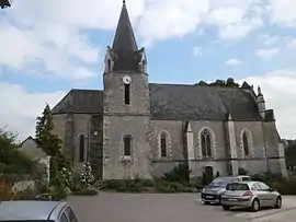 The church of Saint-Pierre-ès-Liens, in Chédigny | |
.svg.png.webp) Coat of arms | |
Location of Chédigny 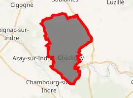
| |
 Chédigny  Chédigny | |
| Coordinates: 47°12′39″N 1°00′01″E | |
| Country | France |
| Region | Centre-Val de Loire |
| Department | Indre-et-Loire |
| Arrondissement | Loches |
| Canton | Loches |
| Intercommunality | CC Loches Sud Touraine |
| Government | |
| • Mayor (2008–2014) | Pierre Louault |
| Area 1 | 23.17 km2 (8.95 sq mi) |
| Population (2017-01-01)[1] | 558 |
| • Density | 24/km2 (62/sq mi) |
| Time zone | UTC+01:00 (CET) |
| • Summer (DST) | UTC+02:00 (CEST) |
| INSEE/Postal code | 37066 /37310 |
| Elevation | 62–110 m (203–361 ft) |
| 1 French Land Register data, which excludes lakes, ponds, glaciers > 1 km2 (0.386 sq mi or 247 acres) and river estuaries. | |
Geography
The village lies on the right bank of the Indrois, which flows northwest through the southern part of the commune.
Population
| Year | Pop. | ±% |
|---|---|---|
| 1793 | 555 | — |
| 1800 | 610 | +9.9% |
| 1806 | 651 | +6.7% |
| 1821 | 696 | +6.9% |
| 1831 | 643 | −7.6% |
| 1836 | 650 | +1.1% |
| 1841 | 659 | +1.4% |
| 1846 | 718 | +9.0% |
| 1851 | 728 | +1.4% |
| 1856 | 763 | +4.8% |
| 1861 | 804 | +5.4% |
| 1866 | 825 | +2.6% |
| 1872 | 839 | +1.7% |
| 1876 | 833 | −0.7% |
| 1881 | 802 | −3.7% |
| 1886 | 738 | −8.0% |
| 1891 | 696 | −5.7% |
| 1896 | 671 | −3.6% |
| 1901 | 633 | −5.7% |
| 1906 | 682 | +7.7% |
| 1911 | 680 | −0.3% |
| 1921 | 592 | −12.9% |
| 1926 | 590 | −0.3% |
| 1931 | 539 | −8.6% |
| 1936 | 553 | +2.6% |
| 1946 | 571 | +3.3% |
| 1954 | 571 | +0.0% |
| 1962 | 465 | −18.6% |
| 1968 | 431 | −7.3% |
| 1975 | 394 | −8.6% |
| 1982 | 420 | +6.6% |
| 1990 | 445 | +6.0% |
| 1999 | 435 | −2.2% |
| 2006 | 519 | +19.3% |
| 2009 | 534 | +2.9% |
References
- "Populations légales 2017". INSEE. Retrieved 6 January 2020.
| Wikimedia Commons has media related to Chédigny. |
| Authority control |
|
|---|
This article is issued from Wikipedia. The text is licensed under Creative Commons - Attribution - Sharealike. Additional terms may apply for the media files.