Ferrière-sur-Beaulieu
Ferrière-sur-Beaulieu is a commune in the Indre-et-Loire department in central France.
Ferrière-sur-Beaulieu | |
|---|---|
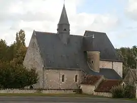 The church of Saint-Gilles, in Ferrière-sur-Beaulieu | |
.svg.png.webp) Coat of arms | |
Location of Ferrière-sur-Beaulieu 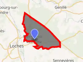
| |
 Ferrière-sur-Beaulieu  Ferrière-sur-Beaulieu | |
| Coordinates: 47°08′19″N 1°02′18″E | |
| Country | France |
| Region | Centre-Val de Loire |
| Department | Indre-et-Loire |
| Arrondissement | Loches |
| Canton | Loches |
| Intercommunality | CC Loches Sud Touraine |
| Government | |
| • Mayor (2008–2014) | Gilbert Sabard |
| Area 1 | 19.63 km2 (7.58 sq mi) |
| Population (2017-01-01)[1] | 734 |
| • Density | 37/km2 (97/sq mi) |
| Time zone | UTC+01:00 (CET) |
| • Summer (DST) | UTC+02:00 (CEST) |
| INSEE/Postal code | 37108 /37600 |
| Elevation | 75–144 m (246–472 ft) |
| 1 French Land Register data, which excludes lakes, ponds, glaciers > 1 km2 (0.386 sq mi or 247 acres) and river estuaries. | |
Population
| Year | Pop. | ±% |
|---|---|---|
| 1793 | 222 | — |
| 1800 | 297 | +33.8% |
| 1806 | 243 | −18.2% |
| 1821 | 242 | −0.4% |
| 1831 | 258 | +6.6% |
| 1836 | 296 | +14.7% |
| 1841 | 280 | −5.4% |
| 1846 | 273 | −2.5% |
| 1851 | 276 | +1.1% |
| 1856 | 301 | +9.1% |
| 1861 | 272 | −9.6% |
| 1866 | 295 | +8.5% |
| 1872 | 291 | −1.4% |
| 1876 | 286 | −1.7% |
| 1881 | 286 | +0.0% |
| 1886 | 314 | +9.8% |
| 1891 | 329 | +4.8% |
| 1896 | 336 | +2.1% |
| 1901 | 285 | −15.2% |
| 1906 | 268 | −6.0% |
| 1911 | 259 | −3.4% |
| 1921 | 249 | −3.9% |
| 1926 | 225 | −9.6% |
| 1931 | 221 | −1.8% |
| 1936 | 251 | +13.6% |
| 1946 | 279 | +11.2% |
| 1954 | 246 | −11.8% |
| 1962 | 246 | +0.0% |
| 1968 | 239 | −2.8% |
| 1975 | 278 | +16.3% |
| 1982 | 365 | +31.3% |
| 1990 | 475 | +30.1% |
| 1999 | 563 | +18.5% |
| 2006 | 611 | +8.5% |
| 2009 | 704 | +15.2% |
References
- "Populations légales 2017". INSEE. Retrieved 6 January 2020.
| Wikimedia Commons has media related to Ferrière-sur-Beaulieu. |
| Authority control |
|---|
This article is issued from Wikipedia. The text is licensed under Creative Commons - Attribution - Sharealike. Additional terms may apply for the media files.