Banda, Uttar Pradesh
Banda is a city and a municipal board in Banda district in the state of Uttar Pradesh, India. Banda is divided between north, east, west and south Banda. Banda lies south of the Yamuna river in the Bundelkhand region. It is the administrative headquarters of Banda District. The town is well connected to major cities with railways and state highways. The town is near the right bank of the river Ken,[4] 189 km south-west of Allahabad.
Banda | |
|---|---|
City | |
 Banda  Banda | |
| Coordinates: 25°29′N 80°20′E | |
| Country | |
| State | Uttar Pradesh |
| District | Banda |
| Government | |
| • Body | Banda Municipality Council[1] |
| • Chairman | Mohan Sahu (S.P.) |
| Area | |
| • Total | 443.1 km2 (171.1 sq mi) |
| Elevation | 123 m (404 ft) |
| Population (2011)[2] | |
| • Total | 154,428 |
| • Density | 350/km2 (900/sq mi) |
| Language | |
| • Official | Hindi[3] |
| • Additional official | Urdu[3] |
| • Other | English, Bundelkhandi |
| Time zone | UTC+5:30 (IST) |
| PIN | 210001 |
| Telephone code | 91-5192 |
| Vehicle registration | UP-90 |
| Sex ratio | 881[2] ♂/♀ |
| Literacy | 82.05% |
| Website | banda |
Banda was a town and district of British India, in the Allahabad division of the United Provinces. The population in 1901 was 22,565. It was formerly, but is no longer, a military cantonment.[4]
Languages
Hindi and Urdu are official languages of the city. Bundeli is natively spoken in Banda.[5]
Government
Civic administration
The city elects members to the Lok Sabha as well as the Uttar Pradesh Vidhan Sabha (State Assembly). The city is under the jurisdiction of a District Magistrate, who is an IAS officer. The Collectors are in charge of property records and revenue collection for the Central Government, and oversee the national elections held in the city. The Collector is also responsible for maintaining law and order in the city. The city is administered by the Banda Municipal Corporation with executive power vested in the Municipal Commissioner of Banda, who is an administrative officer. The corporation comprises elected members (corporators elected from the wards directly by the people) with City Mayor as its head. An Assistant Municipal Commissioner oversees each ward for administrative purposes. The Banda Police is headed by a Deputy Inspector General, who is an IPS officer. The Banda Police comes under the state Home Ministry. The city is divided into several police zones and traffic police zones. The Traffic Police is a semi-autonomous body under the Banda Police. The Banda Fire Brigade department is headed by the Chief Fire Officer, who is assisted by Deputy Chief Fire Officers and Divisional Officers.
Economy
It contains an area of 3,061 square miles (7,930 km2). In some parts it rises into irregular uplands and elevated plains, interspersed with detached rocks of granite; in others it sinks into marshy lowlands, which frequently remain under water during the rainy season. The sloping country on the bank of the Yamuna (previously called Jamuna)is full of ravines. To the south-east the Vindhya chain of hills takes its origin in a low range not exceeding 500 feet (150 m) in height, and forming a natural boundary of the district in that direction. The principal river of the district is the Yamuna, which flows from north-west to south-east, along the north-east boundary of the district, for 125 miles (201 km) The black soil of the district yields crops of which the principal are millet, other food-grains, pulse, rice, cotton and oil-seeds. Banda cotton enjoys a high repute in the market. A branch railway from Manikpur to Jhansi traverses the length of the district, which is also crossed by the East Indian main line to Jabalpur (earlier Jubbulpore).[4]
The BDA (Banda development Authority) has planned to make one mall in town. 1 India Family Mart,[6] a mid scale shopping store, is currently giving their service to the city.
Climate
| Climate data for Banda, Uttar Pradesh (1981–2010, extremes 1949–2012) | |||||||||||||
|---|---|---|---|---|---|---|---|---|---|---|---|---|---|
| Month | Jan | Feb | Mar | Apr | May | Jun | Jul | Aug | Sep | Oct | Nov | Dec | Year |
| Record high °C (°F) | 32.8 (91.0) |
38.2 (100.8) |
43.0 (109.4) |
46.7 (116.1) |
48.8 (119.8) |
48.9 (120.0) |
45.6 (114.1) |
42.6 (108.7) |
41.6 (106.9) |
40.6 (105.1) |
37.4 (99.3) |
32.2 (90.0) |
48.9 (120.0) |
| Average high °C (°F) | 22.8 (73.0) |
28.0 (82.4) |
34.3 (93.7) |
40.6 (105.1) |
43.1 (109.6) |
40.7 (105.3) |
34.9 (94.8) |
33.5 (92.3) |
33.8 (92.8) |
34.4 (93.9) |
30.8 (87.4) |
25.2 (77.4) |
33.5 (92.3) |
| Average low °C (°F) | 9.1 (48.4) |
12.0 (53.6) |
17.3 (63.1) |
22.8 (73.0) |
26.9 (80.4) |
28.2 (82.8) |
26.3 (79.3) |
25.4 (77.7) |
24.8 (76.6) |
20.0 (68.0) |
14.2 (57.6) |
10.2 (50.4) |
19.7 (67.5) |
| Record low °C (°F) | 0.6 (33.1) |
3.2 (37.8) |
7.3 (45.1) |
13.1 (55.6) |
17.2 (63.0) |
18.8 (65.8) |
16.9 (62.4) |
15.7 (60.3) |
14.7 (58.5) |
8.8 (47.8) |
2.7 (36.9) |
−0.8 (30.6) |
−0.8 (30.6) |
| Average rainfall mm (inches) | 15.1 (0.59) |
15.7 (0.62) |
5.8 (0.23) |
5.0 (0.20) |
15.1 (0.59) |
89.6 (3.53) |
231.4 (9.11) |
268.8 (10.58) |
199.5 (7.85) |
35.3 (1.39) |
4.4 (0.17) |
9.9 (0.39) |
895.6 (35.26) |
| Average rainy days | 1.3 | 1.3 | 0.6 | 0.6 | 1.4 | 4.6 | 11.5 | 11.8 | 8.0 | 1.7 | 0.4 | 0.7 | 44.0 |
| Average relative humidity (%) (at 17:30 IST) | 62 | 50 | 37 | 28 | 30 | 45 | 71 | 77 | 73 | 57 | 54 | 62 | 54 |
| Source: India Meteorological Department[7][8] | |||||||||||||
Demographics
As per 2011 Indian Census, Banda has a population of 154,428, out of which males are 82,116 and females are 72,312. Population in the age group of 0 to 6 years is 18,621. The total number of literates in Banda was 111,432, which constituted 72.16% of the population with male literacy of 77.4% and female literacy of 66.2%. The effective literacy rate of 7+ population of Banda was 82.1%, of which male literacy rate was 87.9% and female literacy rate was 75.4%. The sex ratio is 881. The Scheduled Castes and Scheduled Tribes had a population of 18,539 and 17 respectively. There were 27987 households as of 2011.[2]
History
This is the easternmost district of Bundelkhand. The division of the district into two has been done by splitting Banda district, tahsil and block-wise. Karwi and Mau Tahsils lying in the eastern and South-eastern direction comprising the Manikpur, Mau, Pahadi, Chitrakut and Ramnagar blocks from the present Chitrakut district.
Banda, which forms one of the districts included under the general name of Bundelkhand, has formed an arena of contention for the successive races who have struggled for the sovereignty of India.[4]
Shamsher Bahadur I (Krishna Rao) was a Maratha ruler of the dominion of Banda. He was the son of Bajirao I and Mastani.[9][10][11] He was bestowed upon a portion of his father's dominion of Banda and Kalpi. In 1761, he and his army contingent were involved (fought alongside the Peshwa) in the Third Battle of Panipat between the Marathas and Afghans. He was wounded in that battle and died a few days later at Deeg.[12] Shamsher's successor Ali Bahadur (Krishna Singh) established his authority over large parts of Bundelkhand and became the Peshwa'a Subedar of Banda. The descendants of Shamsher Bahadur continued their allegiance towards the Maratha polity and his grandson, Shamsher Bahadur II, fought the English in the Anglo-Maratha War of 1803.[13]
Banda participated in the Indian Freedom Struggle under the leadership of Bundelkhand Kesri Dewan Shatrughan Singh & Rani Rajendra Kumari.
Transport
Road transport
The available multiple modes of public transport in the city are taxis, cycle rickshaws, auto rickshaws. National Highway 76 (India) passes through Banda which connects it to Jhansi and Allahabad. State Highway 92, connects banda to Fatehpur. state highway 76 connects to allahabad. National Highway 86 connects to Kanpur. Apart from the long-distance services, there are many services to nearby places within the state. There are a number of daily buses to Kanpur, Allahabad, Delhi, Sagar, Lucknow, Jhansi, Khajuraho, in Uttar Pradesh and to many other states. You can also reach Kanpur by road Bara Galauli, Pailani Road.
Railways
Banda is served by Banda railway station, a Category A station, under the Jhansi railway division of the North Central Railway Zone.[14] It is well connected by trains with all major cities namely Kolkata, Delhi, Mumbai, Lucknow, Bhopal, Bilaspur, Gwalior, Jabalpur, Raipur, Varanasi, Agra. The city is well connected to Kanpur, Allahabad, Jhansi, and other neighbouring cities.

The electrification of railway line is under progress and be finished by the end second quarter 2019.
Places of interest
Bamdeveshwar Temple and Mount

The temple is said to derive its name from Bamdeo Rishi, a sage mentioned in Hindu mythology as a contemporary of Lord Rama. Bamdeo is said to have had his hermitage at the foot of a hill. There is one big and oldest Shivling is situated in the temple in the kho of Bambeshar Pahar.
Bhuragarh Fort
Across the river Ken there are ruins of Bhuragarh Fort, said to be built with brown stones by Raja Guman Singh in the 17th century. This place was important during the freedom struggle. A mela is organised in this place called ‘Natbali Ka Mela’.
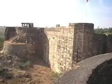
Bhuragrah Fort is situated at the bank of the Ken river. Seeing the sunset from the fort is a beautiful experience. The historical importance of Bhuragarh Fort is related to Bundela reign and Hridaya Shah and Jagat Rai, sons of Maharaja Chattrasal. Kirat Singh, son of Jagat Rai, repaired Bhuragarh Fort in 1746 A.D. None Arjun Singh was the caretaker of the fort.
In 1787 AD, Nawab Ali Bahudur I started looking after the Banda domain. He fought a war against None Arjun Singh in 1792 A.D. Then it came under the Nawab's rule for some time but Rajaram Dauwa and Laxman Dauwa won it again from the Nawabs. After the death of None Arjun Singh, Nawab Ali Bahudar took the control of Bhuragarh Fort. The Nawab died in 1802 A.D. and Gaurihar Maharaj took the administration after him.
The Indian Rebellion of 1857 started on 14 June 1857. In Banda it was led by Nawab Ali Bahadur II. This struggle was much fiercer than expected and revolutionaries from Allahbad, Kanpur and Bihar joined the Nawab in fighting the British. On 15 June 1857, revolutionaries killed Joint Magistrate Cockrail. On 16 April 1858, Whitluck arrived in Banda and fought against the revolutionary army of Banda. About 3000 revolutionaries were killed in the fort during this war. Nuts (one who performs acrobatic feats) from Sarbai sacrificed their lives in this war. Their graves are found inside the fort. Graves of many revolutionaries are found around the fort.
Gudha ke Hanuman Ji
This temple is situated in Gudha kalan and is about 40 km from Banda.
Jain Mandir
A historical temple in Banda city. It is located near Chhoti Bazar.
Jama-Masjid

One of the oldest mosques in the city.
Kalinjar Fort

The most famous place to visit from the city is ancient Kalinjer Fort which is located south of Banda and is mentioned in the Mahabharata.
Angleshwari Devi (Vindhyavasini) Temple
There is also a temple on the top of a hill called Khatri Pahar at Shydha, which is located approximately 24 km from the city. The temple is dedicated to goddess Angleshwari (Vindhyavasini).[15][16]
Maheshwari Devi Temple
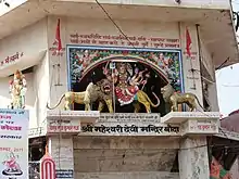
This temple is situated at the middle place of the Banda city. There are many murtis of Devis and Devatas in the temple.
Nawab Tank
Nawab tank, which was built to fulfill the water needs in Banda, is situated about 3 km south of Banda. This tank was built by the Nawab of Banda, and therefore it is known as the Nawab Tank.
Sankat Mochan Mandir
This temple is situated in Kachehari Road.
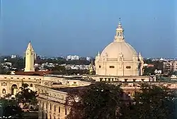
St. George's Church (Yellow Church)

St. George's Church aka Yellow Church, established in 1835 AD, is the most famous and oldest church of Banda. Some records have been found that proved that Christianity was in Banda before 1809 AD. Yellow Church was built by Church of England, India for regular prayers of Anglo Catholic Englishmen and their families living in Banda during British period. Earlier, the Church was under the Church of North India, Calcutta Diocese, but after 1893 a new Diocese of Lucknow was carved out from the Calcutta diocese. The Church is dedicated to the British patron saint George the Martyr. The Church has many historic memorials of British officers in Banda. There is a grave of British officers inside the church. Outside the Church, there are three graves of British officers from the Royal Army and the grave of the first Chaplain of the church. During 1857 revolt, no damage was made to the Church. The roof gardens of this Church is made up of English cast iron. The Church is built in Italian style with conical tops and tall windows. The church was Anglo catholic. It is also known as the garrison church of the city. It is counted among the oldest Anglican churches in northern India. Now the church is under the Church of North India, Diocese of Lucknow.
Education
References
- "DISTRICT BANDA". banda.nic.in. Retrieved 1 September 2020.
- "Census of India: Banda". www.censusindia.gov.in. Retrieved 30 December 2019.
- "52nd Report of the Commissioner for Linguistic Minorities in India" (PDF). nclm.nic.in. Ministry of Minority Affairs. Archived from the original (PDF) on 25 May 2017. Retrieved 21 December 2018.
-
 One or more of the preceding sentences incorporates text from a publication now in the public domain: Chisholm, Hugh, ed. (1911). "Banda". Encyclopædia Britannica. 3 (11th ed.). Cambridge University Press.
 - "Ethnologue - Bundeli". Ethnologue. Retrieved 27 December 2018.
- "1 India Family Mart (Banda)". 1 India Family Mart (Banda). Retrieved 11 July 2018.
- "Station: Banda Climatological Table 1981–2010" (PDF). Climatological Normals 1981–2010. India Meteorological Department. January 2015. pp. 79–80. Archived from the original (PDF) on 5 February 2020. Retrieved 6 May 2020.
- "Extremes of Temperature & Rainfall for Indian Stations (Up to 2012)" (PDF). India Meteorological Department. December 2016. p. M213. Archived from the original (PDF) on 5 February 2020. Retrieved 6 May 2020.
- Bhawan Singh Rana (1 January 2005). Rani of Jhansi. Diamond. pp. 22–23. ISBN 978-81-288-0875-3.
- Chidambaram S. Srinivasachari (dewan bahadur) (1951). The Inwardness of British Annexations in India. University of Madras. p. 219.
- Rosemary Crill; Kapil Jariwala (2010). The Indian Portrat, 1560–1860. Mapin Publishing Pvt Ltd. p. 162. ISBN 978-81-89995-37-9.
- Henry Dodwell (1958). The Cambridge History of India: Turks and Afghans. CUP Archive. pp. 407–. GGKEY:96PECZLGTT6.
- Jadunath Sarkar (1 January 1992). Fall of the Mughal Empire: 1789–1803. Sangam. pp. 11–. ISBN 978-0-86131-749-3.
- "Statement showing Category-wise No.of stations in IR based on Pass. earning of 2011" (PDF). Archived from the original (PDF) on 28 January 2016. Retrieved 15 January 2016.
- "Archived copy". Archived from the original on 12 August 2013. Retrieved 26 April 2014.CS1 maint: archived copy as title (link)
- Sharma, Ruchi (1 May 2001). "इस मंदिर की मान्यता जानकर रह जाएंगे हैरान, दूर- दूर से आते हैं लोग". Patrika News (in Hindi). Retrieved 9 February 2020.