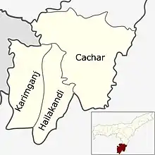
Barak Valley
The Barak Valley[1] is located in the southern region of the Indian state of Assam. The main city of the valley is Silchar. The region is named after the Barak river. The Barak valley mainly consists of three administrative districts of Assam - namely Cachar, Karimganj, and Hailakandi. Among these three districts, Cachar and Hailakandi historically belonged to the Kachari Kingdom before the British Raj, whereas Karimganj belonged to the Sylhet region then Assam province, which was then separated from Sylhet after the 1947 referendum; with the rest of Sylhet falling under East Pakistan (now Bangladesh) and Karimganj under India.
History
The region was originally part of the Tripura kingdom. In 1562 Chilarai annexed the Cachar region to the Koch kingdom and it became a part of the Koch kingdom administered by his half-brother Kamalnarayan.[2] After the death of Nara Narayan, the region became independent and was ruled by the descendants of Kamalnarayan. In the 17th-century, the last Koch ruler's daughter married the king of the Kachari kingdom, and the rule of Khaspur passed into the hands of the Kachari rulers, who eventually moved their capital from Maibang to Khaspur.[3]
The Kachari kingdom was annexed to British-India in 1832. The headquarters of the district was Silchar. The British Companies established a very large number of Tea Gardens (total 157) in the area and Silchar emerged as a very important center in this part of the country.
Inclusion of Karimganj
In 1947, when a plebiscite was held in Sylhet with majority voting for incorporation with Pakistan. The Sylhet district was divided into two; the easternmost subdivision of Sylhet which is known as Karimganj remained with India whereas the rest joined East Bengal. Geographically the region is surrounded by hills from all three sides except its western plain boundary with Bangladesh. Nihar Ranjan Roy, author of Bangalir Itihash, claims that "South Assam / Northeastern Bengal or Barak Valley is the extension of the Greater Surma/Meghna Valley of Bengal in every aspect from culture to geography".[4]
Assam's Surma Valley (now partly in Bangladesh) had Muslim-majority population. On the eve of partition, hectic activities intensified by the Muslim League as well Congress with the former having an edge. A referendum had been proposed for Sylhet District. Abdul Matlib Mazumdar along with Basanta Kumar Das (then Home Minister of Assam) travelled throughout the valley organising the Congress and addressing meetings educating the masses about the outcome of partition on the basis of religion.[5] On 20 February 1947 Moulvi Mazumdar inaugurated a convention – Assam Nationalist Muslim's Convention at Silchar. Thereafter another big meeting was held at Silchar on 8 June 1947.[6] Both the meetings, which were attended by a large section of Muslims paid dividend. He was also among the few who were instrumental in retaining the Barak Valley region of Assam, especially Karimganj with India.[7][8] Mazumdar was the leader of the delegation that pleaded before the Radcliffe Commission that ensured that a part of Sylhet (now in Bangladesh) remains with India despite being Muslim-majority (present Karimganj district).[9][10]
Demographics
According to the 2011 Indian census, Barak valley had a population of 3,624,599.[11]
| Year | Pop. | ±% |
|---|---|---|
| 1901 | 630,302 | — |
| 1911 | 713,566 | +13.2% |
| 1921 | 751,560 | +5.3% |
| 1931 | 803,694 | +6.9% |
| 1941 | 895,140 | +11.4% |
| 1951 | 1,115,865 | +24.7% |
| 1961 | 1,378,476 | +23.5% |
| 1971 | 1,713,318 | +24.3% |
| 1981 | - | — |
| 1991 | 2,491,496 | — |
| 2001 | 2,995,769 | +20.2% |
| 2011 | 3,624,599 | +21.0% |
| Source: [12][13] | ||
Languages and religion
Bengali is the official language of Barak Valley.[14] Sylheti is spoken by the majority of the people who identify as Bengali speakers in the census.[15][16]
According to census 2011, the major languages of Cachar district are Bengali, Hindi, Manipuri, Bhojpuri, Bishnupriya Manipuri, Dimasa, Khasi, Hmar and Odia in descending order of population. In the Hailakandi district, the major languages are Bengali, Hindi, Tripuri language, Manipuri and Bhojpuri. In the Karimganj district, the major languages are Bengali and Hindi.[16][lower-alpha 1]
Religions in Barak Valley (2011) [11]
Hinduism is the majority religion in the Barak Valley. The religious composition of the valley population is as follows: Hindus 50%, Muslims 48.1%, Christians 1.6%, and others 0.3%. Hindus are the majority in Cachar district (59.83%) with having (86.31%) Hindu in the district headquarter ; Silchar (which is also the main city of the valley). While Muslims are the majority in Hailakandi district (60.31%) and Karimganj district (56.36%), but Hailakandi town have (67.26%) Hindu majority, Karimganj town have also a Hindu Majority of (86.57%) as of 2011 census.[11]
"Barak valley" 1951 census
Barak Valley had a population of 1,115,865 as per 1951 census of India. The Hindu population was 676,660, muslim population was 429,496, while others constitute 0.89% as per as 1951 census.
Population by district tehsils (2011)
Source: censusindia.co.in
1) Cachar district total- 1,736,617
Sonai circle - 324,315
Katigora circle - 291,875
Udharbond circle - 124,090
Lakhipur circle - 291,872
Silchar circle - 704,465
2) Hailakandi district total - 659,296 (2011)
Algapur circle - 121,379
Hailakandi circle - 166,897
Katlichara circle - 168,077
Lala circle - 202,943
3) Karimganj district total - 1,228,686 (2011)
Badarpur circle - 164,703
Karimganj circle - 278,300
Nilambazar circle - 242,451
Patharkandi circle - 261,368
Ramkrishna Nagar circle - 281,864
Trends
| Year (census) | Hindu population and percentage | Muslim population and percentage |
|---|---|---|
| 1951 | 676,660 (60.63%) | 429,496 (38.48%) |
| 1961 | 821,600 (59.60%) | 539,457 (39.13%) |
| 1971 | 1,005,995 (58.71%) | 683,387 (39.88%) |
| 1991 | 1,381,803 (55.46%) | 1,071,872 (43.02%) |
| 2001 | 1,580,660 (52.76%) | 1,362,114 (45.46%) |
| 2011 | 1,812,141 (50.00%) | 1,744,958 (48.1%) |
Hindu and Muslim population by district tehsils
| District Cachar/Tehsils | Hindu population and percentage | Muslim population and percentage |
|---|---|---|
| Sonai circle | 133,507 (41.17%) | 184,588 (56.92%) |
| Katigora circle | 131,352 (45%) | 156,290 (53.55%) |
| Udharbond circle | 87,423 (70.45%) | 32,320 (26.05%) |
| Lakhipur circle | 178,163 (61.04%) | 95,476 (32.71%) |
| Silchar circle | 508,540 (72.19%) | 186,142 (26.42%) |
Hindus are majority in three tehsils of Cachar district namely Silchar, Lakhipur and Udharbond, while Muslims are majority in Katigora and Sonai circle according to 2011 census.
| District Hailakandi/Tehsils | Hindu population and percentage | Muslim population and percentage |
|---|---|---|
| Algapur circle | 38,501 (31.72%) | 82,126 (67.66%) |
| Hailakandi circle | 47,198 (28.28%) | 118,626 (71.08%) |
| Katlichara circle | 79,019 (47.01%) | 84,044 (50%) |
| Lala circle | 86,476 (42.61%) | 112,857 (55.61%) |
Hindus are significant in two tehsils of Hailakandi namely Katlichara and Lala, while Muslims are majority in all the three tehsils, but in Katlichara muslims form a plurality according to 2011 census.
| District Karimganj/Tehsils | Hindu population and percentage | Muslim population and percentage |
|---|---|---|
| Badarpur circle | 56,800 (34.49%) | 106,909 (64.91%) |
| Karimganj circle | 117,877 (42.36%) | 159,068 (57.16%) |
| Nilambazar circle | 58,767 (24.24%) | 182,567 (75.3%) |
| Patharkandi circle | 129,502 (49.55%) | 124,768 (47.74%) |
| Ramkrishna Nagar circle | 159,016 (56.42%) | 119,177 (42.28%) |
Hindus are majority in two tehsils of Karimganj namely Patharkandi and Ramkrishna Nagar, while Muslims are majority in Nilambazar, Badarpur and Karimganj circle according to 2011 census.
Statehood demand
There have been continuous demand in Bengali dominated Barak valley for separate statehood and curved it out from Assamese majority Brahmaputra valley post NRC.[19] Barak valley is the most neglected part of Assam in terms of its infrastructure development, tourism sector, educational institutions, hospitals, IT industries, etc which is still lagging behind in comparison to the Assam's mainland Brahmaputra valley which have access to all of those facilities mentioned above.[20]
Social issues
The number of Hindu immigrants from Bangladesh in Barak Valley has varied estimates. According to the Assam government, 1.3 lakh such people residing in the Barak Valley are eligible for citizenship if the Citizenship Amendment Act of 2019 becomes a law.[21]
Economy
Tea is the important economic activity and Barak Valley have also its proportional share of tea garden in comparison to Brahmaputra valley to sustains its economy from time to time. There are plenty of oil and natural gas under the surface of Barak valley as well to run the economy as a separate state. Various oil refineries are also set up in various locations of Barak valley to meet the required economic demand.[22]
Forest cover
There are around 104 forest Villages in Barak Valley.[23] Among the three districts in Barak Valley, Cachar have an area of 3,786 sq km², out of which 2222.34 sq km² area is covered with forest, Hailakandi district have a total area of 1,327 sq km², out of which 774.34 sq km² is covered with forest, Karimganj district have a total area of 1,809 sq km², out of which 851.43 sq km² area is covered with forest.[24]
List of districts in Barak valley
There are three district in Barak Valley.
- Karimganj having an area of 1,809 km² and is the second largest district of the valley.
- Hailakandi having an area of 1,327 km² is third largest district of the valley.
- Cachar having an area of 3,786 km². It is the largest district of the valley.
Wildlife
The Asian elephant has already vanished from most of the valley.[25][26][27] Barail is the only wildlife sanctuary of the Barak valley region. It was initiated by noted naturalist Dr Anwaruddin Choudhury, who originally hailed from this region in the early 1980s.[28] This sanctuary was ultimately notified in 2004. There are thirteen reserve forests in the valley comprising six in Karimganj, five in Cachar, and two are in Hailakandi.[29][30] The Patharia hills reserve forest of Karimganj is the habitat of many mammals and was recommended to upgrade as 'Patharia hills wildlife sanctuary'.[31] The southern part was also recommended as 'Dhaleswari' wildlife sanctuary.[32]
Constituencies
Barak Valley has two Lok Sabha seats.
Barak Valley has fifteen Assam Legislative Assembly seats.
- Badarpur
- Algapur
- Hailakandi
- Katlicherra
- Karimganj South
- Karimganj North
- Ratabari
- Patharkandi
- Katigorah
- Dholai
- Udharbond
- Sonai
- Silchar
- Barkhola
- Lakhipur
Districts tehsils
- Cachar district -: Katigora, Sonai, Silchar, Udharbond, Lakhipur.
- Hailakandi district -: Algapur, Hailakandi, Katlichara, Lala.
- Karimganj district -: Badarpur, Karimganj, Nilambazar, Patharkandi, Ramkrishna Nagar.
Notable people
- Abdul Matlib Mazumdar, freedom fighter, cabinet minister in last ministry during British period and then after independence, in the first and subsequent ministries. Assam's first Agriculture, Veterinery, & Local self-government minister
- Moinul Hoque Choudhury, ex-Minister of Industries during Indira Gandhi regime, established All India Radio, National Institute of Technology, Silchar, Hindustan Paper Mill at Panchgram and Sugar Mill at Anipur
- Karnendu Bhattacharjee, ex-MP of Rajya Sabha, Indian National Congress
- Debojit Saha, singer and television host
- Radheshyam Biswas, former member of Lok Sabha), AIUDF
- Santosh Mohan Dev, former member of Lok Sabha), Indian National Congress, former Minister of Heavy Industry and Public Enterprises in the Union Cabinet
- Aminul Haque Laskar, Deputy Speaker of the Assam Legislative Assembly, Bharatiya Janata Party
- B. B. Bhattacharya, former Vice-Chancellor, Jawaharlal Nehru University, New Delhi
- Sushmita Dev (President), All India Mahila Congress
- Kalika Prasad Bhattacharya, singer
- Rajdeep Roy, Member of Lok Sabha, Silchar
- Kripanath Mallah, Member of Lok Sabha, Karimganj
Notes
- Languages constituting less than 1% and/or substantially lower as compared to the total population are not included
References
- (Tunga 1995, p. 1)
- (Bhattacharjee 1994:71)
- (Bhattacharjee 1994:72)
- Ray, Niharranjan (1 January 1980). Bangalir itihas (in Bengali). Paschimbanga Samiti.
- Chowdhury, Dewan Nurul Anwar Husain. "Sylhet Referendum, 1947". en.banglapedia.org. Banglapedia. Retrieved 20 November 2016.
- Bhattacharjee, J. B. (1977). Cachar under British Rule in North East India. Radiant Publishers, New Delhi.
- Barua, D. C. (1990). Moulvi Matlib Mazumdar- as I knew him. Abdul Matlib Mazumdar – birth centenary tributes, pp. 8–9.
- Purkayashta, M. (1990). Tyagi jananeta Abdul Matlib Mazumdar. The Prantiya Samachar (in Bengali). Silchar, India.
- Roy, S. K. (1990). Jananeta Abdul Matlib Mazumdar (in Bengali). Abdul Matlib Mazumdar – birth centenary tributes, pp. 24–27.
- "Assam Election Results - What does it mean for Bangladesh?". thedailystar.net. The Daily Star. 21 May 2016. Retrieved 20 November 2016.
- "C-16 Population By Religion - Barak Valley". census.gov.in. Retrieved 25 August 2020.
- Census of India
- Decadal Variation In Population Since 1901
- "Govt withdraws Assamese as official language from Barak valley". Business Standard India. Press Trust of India. 9 September 2014. Retrieved 16 December 2019.
- "Sylheti". Ethnologue. Retrieved 27 January 2020.
- "C-16 Population By Mother Tongue". census.gov.in. Retrieved 3 September 2020.
- "Citizenship Amendment Act: BJP chasing ghosts in Assam; Census data shows number of Hindu immigrants may have been exaggerated - India News , Firstpost". Firstpost. 18 December 2019.
- "C-1 Population By Religious Community". censusindia.gov.in. Retrieved 26 January 2021.
- "'Separate state a better option for Bengalis'". Sentinel Assam. 30 October 2018. Retrieved 30 November 2020.
- Saikia, Arunabh (29 December 2017). "A tale of two valleys: What's behind the demand for a separate Union Territory in southern Assam?". Scroll.in. Retrieved 30 November 2020.
- Naqvi, Sadiq (11 December 2019). "Bengali Hindu refugees in Assam's Barak Valley hope for CAB's passage in RS". Hindustan Times. Retrieved 7 December 2020.
- "Professor and economist Joydeep Biswas on Barak Valley as a separate state: It would not be any worse than what it is now".
- "Human-Wildlife Conflict in the Forest Villages of Barak Valley, Assam, India". Current World Environment. 10 (1). 30 April 2015 – via www.cwejournal.org.
- 11.3.1 Introduction Assam the second ... - Forest Survey of India
- Talukdar, N.R., Choudhury, P. (2017) Conservation status of Asiatic elephant in southern Assam, India. Gajah 47:18–23.
- Choudhury, A.U. (1999). Status and Conservation of the Asian elephant Elephas maximus in north-eastern India. Mammal Review 29(3): 141-173.
- Choudhury, A.U. (2004). Vanishing habitat threatens Phayre’s leaf monkey. The Rhino Found. NE India Newsletter 6:32-33.
- Choudhury, A.U. (1989). Campaign for wildlife protection:national park in the Barails. WWF-Quarterly No. 69,10(2): 4-5.
- Choudhury, A.U. (2005). Amchang, Barail and Dihing-Patkai – Assam’s new wildlife sanctuaries. Oryx 39(2): 124-125.
- Talukdar, N.R., Singh, B., Choudhury, P. (2018) Conservation status of some endangered mammals in Barak Valley, Northeast India. Journal of Asia-Pacific Biodiversity 11:167–172.
- Talukdar, N.R., Choudhury, P. (2017). Conserving wildlife wealth of Patharia Hills reserve Forest, Assam, India: a critical analysis. Global Ecology and Conservation 10:126–138.
- Choudhury, A.U. (1983). Plea for a new wildlife refuge in eastern India. Tigerpaper 10(4):12-15.
Sources
- Bhattacharjee, J B (1994), "Pre-colonial Political Structure of Barak Valley", in Sangma, Milton S (ed.), Essays on North-east India: Presented in Memory of Professor V. Venkata Rao, New Delhi: Indus Publishing Company, pp. 61–85
- Tunga, S. S. (1995). Bengali and Other Related Dialects of South Assam. Delhi: Mittal Publications. Retrieved 19 February 2013.
See also
External links
- Barak Valley
- News Portal on Barak Valley
- Barak velliy news
- Web Portal on Barak Valley
- National freedom struggle :In Barak-Surma Valley of Assam