Beaulieu, Côte-d'Or
Beaulieu is a commune in the Côte-d'Or department in eastern France.
Beaulieu | |
|---|---|
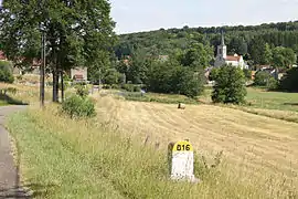 The road into Beaulieu | |
.svg.png.webp) Coat of arms | |
Location of Beaulieu 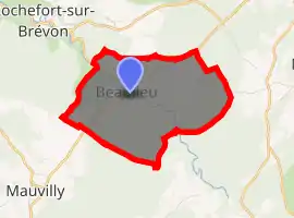
| |
 Beaulieu  Beaulieu | |
| Coordinates: 47°43′41″N 4°43′43″E | |
| Country | France |
| Region | Bourgogne-Franche-Comté |
| Department | Côte-d'Or |
| Arrondissement | Montbard |
| Canton | Châtillon-sur-Seine |
| Intercommunality | Pays Châtillonnais |
| Government | |
| • Mayor (2008–2014) | Gérard Defer |
| Area 1 | 6.6 km2 (2.5 sq mi) |
| Population (2017-01-01)[1] | 27 |
| • Density | 4.1/km2 (11/sq mi) |
| Time zone | UTC+01:00 (CET) |
| • Summer (DST) | UTC+02:00 (CEST) |
| INSEE/Postal code | 21052 /21510 |
| Elevation | 310–425 m (1,017–1,394 ft) (avg. 300 m or 980 ft) |
| 1 French Land Register data, which excludes lakes, ponds, glaciers > 1 km2 (0.386 sq mi or 247 acres) and river estuaries. | |
Geography
Beaulieu is a small community (less than seven square kilometers) positioned on the plateau of Chatillonais off of the western area of the Langres plateau. The area consists of three kilometers of sloping hills with two rivers that are mostly forested with the southern area part of the great forest of Chatillon.
Population
| Year | Pop. | ±% |
|---|---|---|
| 1962 | 40 | — |
| 1968 | 52 | +30.0% |
| 1975 | 39 | −25.0% |
| 1982 | 38 | −2.6% |
| 1990 | 37 | −2.6% |
| 1999 | 33 | −10.8% |
| 2008 | 29 | −12.1% |
See also
References
- "Populations légales 2017". INSEE. Retrieved 6 January 2020.
| Wikimedia Commons has media related to Beaulieu (Côte-d'Or). |
| Authority control |
|
|---|
This article is issued from Wikipedia. The text is licensed under Creative Commons - Attribution - Sharealike. Additional terms may apply for the media files.