Burnham, Illinois
Burnham is a village in Cook County, Illinois, United States. The population was 4,206 at the 2010 census.[3] The ZIP code is 60633.
Burnham, Illinois | |
|---|---|
Village | |
| Village of Burnham | |
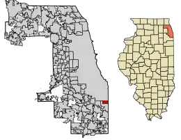 Location of Burnham in Cook County, Illinois. | |
.svg.png.webp) Location of Illinois in the United States | |
| Coordinates: 41°38′8″N 87°33′5″W | |
| Country | |
| State | Illinois |
| County | Cook |
| Township | Thornton |
| Incorporated | 1907 |
| Government | |
| • Type | Council–manager |
| • President | Robert E. Polk |
| Area | |
| • Total | 1.94 sq mi (5.02 km2) |
| • Land | 1.85 sq mi (4.80 km2) |
| • Water | 0.09 sq mi (0.22 km2) 4.62% |
| Population (2010) | |
| • Total | 4,206 |
| • Estimate (2019)[2] | 4,088 |
| • Density | 2,203.77/sq mi (850.94/km2) |
| Up 0.86% from 2000 | |
| Standard of living (2007-2011) | |
| • Per capita income | $18,234 |
| • Median home value | $143,200 |
| ZIP code(s) | 60633 |
| Area code(s) | 708 |
| Geocode | 17-09798 |
| FIPS code | 17-09798 |
| Website | villageofburnhamil.com |
| Demographics (2010)[3] | |||
|---|---|---|---|
| White | Black | Asian | |
| 26.1% | 61.9% | 0.5% | |
| Islander | Native | Other | Hispanic (any race) |
| 0.0% | 0.7% | 10.8% | 19.1% |
Burnham has a Chicago ZIP code, and is often mistakenly considered part of Chicago. It is, however, an independent municipality lying just south of the Chicago city limits.
Burnham was named for Telford Burnham who drew its plat; not, as is widely assumed, by Chicago city planner and architect Daniel Burnham.
There are two sections of Burnham. The westernmost section surrounds Torrence Avenue, a north–south street. Torrence Avenue leaves this part of Burnham via a bridge, with Chicago on the other side. The eastern section surrounds Burnham Avenue, another north–south street. This section of Burnham ends at Brainard Avenue, where the Hegewisch neighborhood of Chicago lies on the other side. Upon entering Chicago, Burnham Avenue becomes Avenue O.
Burnham is bordered by Chicago to the north, Calumet City to the south and west, and Hammond, Indiana, to the east.
Geography
Burnham is located at 41°38′8″N 87°33′5″W (41.635535, -87.551284).[4]
According to the 2010 census, Burnham has a total area of 1.956 square miles (5.07 km2), of which 1.87 square miles (4.84 km2) (or 95.6%) is land and 0.086 square miles (0.22 km2) (or 4.4%) is water.[5]
Demographics
| Historical population | |||
|---|---|---|---|
| Census | Pop. | %± | |
| 1910 | 328 | — | |
| 1920 | 795 | 142.4% | |
| 1930 | 994 | 25.0% | |
| 1940 | 865 | −13.0% | |
| 1950 | 1,331 | 53.9% | |
| 1960 | 2,478 | 86.2% | |
| 1970 | 3,634 | 46.7% | |
| 1980 | 4,030 | 10.9% | |
| 1990 | 3,916 | −2.8% | |
| 2000 | 4,170 | 6.5% | |
| 2010 | 4,206 | 0.9% | |
| 2019 (est.) | 4,088 | [2] | −2.8% |
| U.S. Decennial Census[6] | |||
As of the census of 2010, there were 4,206 residing in the village. The racial makeup of the village was 26.1% White, 61.9% African American, 0.7% Native American, 0.5% Asian, 8.9% from other races, and 1.9% from two or more races. Hispanic or Latino of any race were 19.1% of the population.
As of the census[7] of 2000, there were 4,170 people, 1,449 households, and 970 families residing in the village. The population density was 2,244.8 people per square mile (865.6/km2). There were 1,539 housing units at an average density of 828.5 per square mile (319.5/km2). The racial makeup of the village was 34.80% White, 54.17% African American, 0.22% Native American, 1.01% Asian, 0.02% Pacific Islander, 7.58% from other races, and 2.21% from two or more races. Hispanic or Latino of any race were 15.23% of the population.
Ancestries: Polish (12.8%), Irish (5.7%), German (4.5%), Italian (2.8%), Subsaharan African (2.3%), English (1.7%).
There were 1,449 households, out of which 36.6% had children under the age of 18 living with them, 41.2% were married couples living together, 20.6% had a female householder with no husband present, and 33.0% were non-families. 28.8% of all households were made up of individuals, and 6.8% had someone living alone who was 65 years of age or older. The average household size was 2.67 and the average family size was 3.31.
In the village, the population was spread out, with 27.6% under the age of 18, 7.5% from 18 to 24, 32.1% from 25 to 44, 21.2% from 45 to 64, and 11.7% who were 65 years of age or older. The median age was 36 years. For every 100 females, there were 92.5 males. For every 100 females age 18 and over, there were 89.6 males.
The median income for a household in the village was $39,053, and the median income for a family was $44,350. Males had a median income of $37,559 versus $27,885 for females. The per capita income for the village was $16,747. About 9.4% of families and 9.8% of the population were below the poverty line, including 14.3% of those under age 18 and 4.4% of those age 65 or over.
Government
Burnham is in Illinois' 2nd congressional district.
Notable people
- Mary Matalin, political consultant and author
References
- "2019 U.S. Gazetteer Files". United States Census Bureau. Retrieved July 14, 2020.
- "Population and Housing Unit Estimates". United States Census Bureau. May 24, 2020. Retrieved May 27, 2020.
- "Profile of General Population and Housing Characteristics: 2010 Demographic Profile Data (DP-1): Burnham village, Illinois". U.S. Census Bureau, American Factfinder. Archived from the original on February 12, 2020. Retrieved February 20, 2013.
- "US Gazetteer files: 2010, 2000, and 1990". United States Census Bureau. 2011-02-12. Retrieved 2011-04-23.
- "G001 - Geographic Identifiers - 2010 Census Summary File 1". United States Census Bureau. Archived from the original on 2020-02-13. Retrieved 2015-08-02.
- "Census of Population and Housing". Census.gov. Retrieved June 4, 2015.
- "U.S. Census website". United States Census Bureau. Retrieved 2008-01-31.
External links
| Major city |  | |
|---|---|---|
| Cities (over 30,000 in 2010) | ||
| Towns and villages (over 30,000 in 2010) |
| |
| Counties | ||
| Regions | ||
| Sub-regions | ||