Châteauneuf, Côte-d'Or
Châteauneuf or Châteauneuf-en-Auxois is a commune in the Côte-d'Or department in eastern France.
Châteauneuf | |
|---|---|
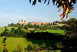 Châteauneuf and its castle | |
.svg.png.webp) Coat of arms | |
Location of Châteauneuf 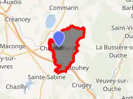
| |
 Châteauneuf  Châteauneuf | |
| Coordinates: 47°13′11″N 4°38′31″E | |
| Country | France |
| Region | Bourgogne-Franche-Comté |
| Department | Côte-d'Or |
| Arrondissement | Beaune |
| Canton | Arnay-le-Duc |
| Government | |
| • Mayor (2008–2014) | Bernard Jeannin |
| Area 1 | 10.06 km2 (3.88 sq mi) |
| Population | 85 |
| • Density | 8.4/km2 (22/sq mi) |
| Time zone | UTC+01:00 (CET) |
| • Summer (DST) | UTC+02:00 (CEST) |
| INSEE/Postal code | 21152 /21320 |
| Elevation | 342–542 m (1,122–1,778 ft) (avg. 475 m or 1,558 ft) |
| 1 French Land Register data, which excludes lakes, ponds, glaciers > 1 km2 (0.386 sq mi or 247 acres) and river estuaries. | |
Population
| Year | Pop. | ±% |
|---|---|---|
| 1962 | 61 | — |
| 1968 | 66 | +8.2% |
| 1975 | 63 | −4.5% |
| 1982 | 62 | −1.6% |
| 1990 | 63 | +1.6% |
| 1999 | 83 | +31.7% |
| 2008 | 86 | +3.6% |
Sights
Châteauneuf is dominated by its château, which was given in December 1456 by Philip the Good to Philippe Pot, whose renovations and fortification gave to it the aspect it retains today, with the arms of Pol and his orders of the Golden Fleece and of Saint-Michel.[2] The medieval bourg that surrounds it is a member of the Les Plus Beaux Villages de France ("The most beautiful villages of France") association.
See also
References
- "Populations légales 2017". INSEE. Retrieved 6 January 2020.
- Jean-Bernard de Vaivre, "Un primitif tiré de l'oubli : le panneau de Philippe Pot de Notre-Dame de Dijon", Comptes rendus de l'Académie des inscriptions et belles-lettres 149.2 (2005:811-858), p. 816 note 12; Vaivre gives a summary biography of Pot, who appears as donor in the recently rediscovered diptych.
| Wikimedia Commons has media related to Châteauneuf (Côte-d'Or). |
| Authority control |
|---|
This article is issued from Wikipedia. The text is licensed under Creative Commons - Attribution - Sharealike. Additional terms may apply for the media files.