Coulounieix-Chamiers
Coulounieix-Chamiers is a commune in the Dordogne department in Nouvelle-Aquitaine in southwestern France. It is a suburb of Périgueux.
Coulounieix-Chamiers | |
|---|---|
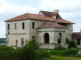 Chateau of Rolphie | |
Location of Coulounieix-Chamiers 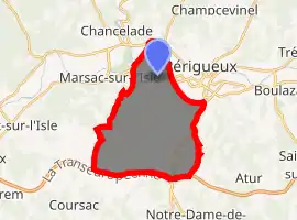
| |
 Coulounieix-Chamiers  Coulounieix-Chamiers | |
| Coordinates: 45°11′14″N 0°41′32″E | |
| Country | France |
| Region | Nouvelle-Aquitaine |
| Department | Dordogne |
| Arrondissement | Périgueux |
| Canton | Coulounieix-Chamiers |
| Government | |
| • Mayor (2008–2014) | Jean-Pierre Roussarie |
| Area 1 | 21.70 km2 (8.38 sq mi) |
| Population (2017-01-01)[1] | 7,703 |
| • Density | 350/km2 (920/sq mi) |
| Time zone | UTC+01:00 (CET) |
| • Summer (DST) | UTC+02:00 (CEST) |
| INSEE/Postal code | 24138 /24660 |
| Elevation | 78–222 m (256–728 ft) (avg. 186 m or 610 ft) |
| 1 French Land Register data, which excludes lakes, ponds, glaciers > 1 km2 (0.386 sq mi or 247 acres) and river estuaries. | |
Population
|
|
International relations
Coulounieix-Chamiers is twinned with:
See also
References
- "Populations légales 2017". INSEE. Retrieved 6 January 2020.
| Wikimedia Commons has media related to Coulounieix-Chamiers. |
| Authority control |
|
|---|
This article is issued from Wikipedia. The text is licensed under Creative Commons - Attribution - Sharealike. Additional terms may apply for the media files.