Le Buisson-de-Cadouin
Le Buisson-de-Cadouin (Occitan: Lo Boisson de Cadonh) is a commune in the Dordogne department in southwestern France. It is situated on the left bank of the river Dordogne. The Gare du Buisson is a railway junction, with connections to Bordeaux, Sarlat-la-Canéda, Agen and Périgueux.
Le Buisson-de-Cadouin | |
|---|---|
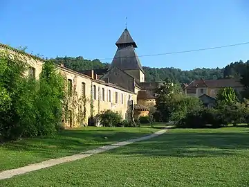 Cadouin Abbey | |
.svg.png.webp) Coat of arms | |
Location of Le Buisson-de-Cadouin 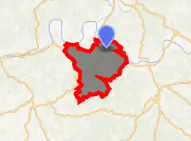
| |
 Le Buisson-de-Cadouin  Le Buisson-de-Cadouin | |
| Coordinates: 44°50′46″N 0°54′37″E | |
| Country | France |
| Region | Nouvelle-Aquitaine |
| Department | Dordogne |
| Arrondissement | Bergerac |
| Canton | Lalinde |
| Intercommunality | Cadouin |
| Government | |
| • Mayor (2008–2014) | Merico Chies |
| Area 1 | 50.37 km2 (19.45 sq mi) |
| Population (2017-01-01)[1] | 1,954 |
| • Density | 39/km2 (100/sq mi) |
| Time zone | UTC+01:00 (CET) |
| • Summer (DST) | UTC+02:00 (CEST) |
| INSEE/Postal code | 24068 /24470 |
| Elevation | 43–248 m (141–814 ft) (avg. 64 m or 210 ft) |
| 1 French Land Register data, which excludes lakes, ponds, glaciers > 1 km2 (0.386 sq mi or 247 acres) and river estuaries. | |
History
In 1893, the commune of Cabans was renamed Le Buisson. In 1960, Cussac and Le Buisson merged to form Le Buisson-Cussac. In 1974, the communes Cadouin, Le Buisson-Cussac, Paleyrac and Urval merged and formed the new commune Le-Buisson-de-Cadouin. Urval separated in 1989.
Cadouin Abbey (founded in 1115, dissolved in 1791) was formerly situated here.
Population
| Year | Pop. | ±% |
|---|---|---|
| 1962 | 2,029 | — |
| 1968 | 2,062 | +1.6% |
| 1975 | 2,078 | +0.8% |
| 1982 | 2,061 | −0.8% |
| 1990 | 2,003 | −2.8% |
| 1999 | 2,075 | +3.6% |
| 2008 | 2,168 | +4.5% |
Demographics
- Students: 4.05%
- Single-parent families: 10.39%
Occupation
- Agriculture: 4%
- Commercial and manufacturing: 12%
- Services: 8%
- Intermediary professions: 14%
- Employees: 36%
- Labourers: 25%
Sights
- Grotte de Cussac, a cave containing more than 100 prehistoric artworks
- Cadouin Abbey, 12th-century Cistercian monastery
- Jardin de Planbuisson
See also
References
- "Populations légales 2017". INSEE. Retrieved 6 January 2020.
External links
| Wikimedia Commons has media related to Le Buisson-de-Cadouin. |
- Buisson-de-Cadouin Le Buisson-de-Cadouin on the Quid site
- Le Buisson-de-Cadouin on the map of France
| Authority control |
|---|
This article is issued from Wikipedia. The text is licensed under Creative Commons - Attribution - Sharealike. Additional terms may apply for the media files.