Saint-Astier, Dordogne
Saint-Astier (Limousin: Sench Astier) is a commune in the Dordogne department in Nouvelle-Aquitaine in southwestern France. It takes its name from a sixth-century saint.
Saint-Astier | |
|---|---|
_%C3%A9glise_(4).JPG.webp) | |
.svg.png.webp) Coat of arms | |
Location of Saint-Astier 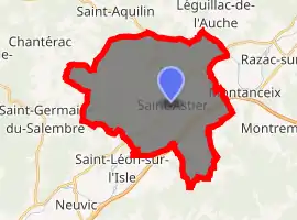
| |
 Saint-Astier  Saint-Astier | |
| Coordinates: 45°08′47″N 0°31′45″E | |
| Country | France |
| Region | Nouvelle-Aquitaine |
| Department | Dordogne |
| Arrondissement | Périgueux |
| Canton | Saint-Astier |
| Government | |
| • Mayor (2008–2014) | Jacques Monmarson |
| Area 1 | 34.25 km2 (13.22 sq mi) |
| Population (2017-01-01)[1] | 5,492 |
| • Density | 160/km2 (420/sq mi) |
| Time zone | UTC+01:00 (CET) |
| • Summer (DST) | UTC+02:00 (CEST) |
| INSEE/Postal code | 24372 /24110 |
| Elevation | 58–222 m (190–728 ft) (avg. 108 m or 354 ft) |
| 1 French Land Register data, which excludes lakes, ponds, glaciers > 1 km2 (0.386 sq mi or 247 acres) and river estuaries. | |
Population
|
|
See also
References
- "Populations légales 2017". INSEE. Retrieved 6 January 2020.
| Wikimedia Commons has media related to Saint-Astier (Dordogne). |
| Authority control |
|---|
This article is issued from Wikipedia. The text is licensed under Creative Commons - Attribution - Sharealike. Additional terms may apply for the media files.