Dakota Formation
The Dakota is a sedimentary geologic unit of formation and group rank composed of sandstones, mudstones, and shales deposited in the late-Early to early-Late Cretaceous Western Interior Seaway.[5] The unit is noted for being exceptionally widespread; from British Columbia and Alberta to Montana and Wisconsin to Colorado and Kansas to Utah and Arizona. It is famous for producing massive colorful rock formations, and preserving both dinosaur footprints and early deciduous tree leaves.
| Dakota Formation / Group Stratigraphic range: Cenomanian | |
|---|---|
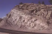 Road cut into the lower Dakota Group at crest of Dinosaur Ridge, near Golden, Colorado | |
| Type | Geologic formation or group |
| Sub-units | Formation (type: Nebraska, Kansas): D/Johnson Clay Member J/Terra Cotta Clay Member Formation (Iowa):[1] Romeroville Sandstone Pajarito Formation Mesa Rica Sandstone |
| Underlies | Graneros Shale (Great Plains) |
| Overlies | Precambian (Sioux Quartzite) to Early Cretaceous (Lytle) |
| Lithology | |
| Primary | Sandstone, mudstone |
| Other | Shale |
| Location | |
| Coordinates | 42.307°N 96.454°W |
| Approximate paleocoordinates | 38.9°N 66.4°W |
| Region | Great Plains, Rocky Mountains, Colorado Plateau, Rio Grande rift valley |
| Country | |
| Type section | |
| Named for | Dakota City, Nebraska |
| Named by | Meek and Hayden |
| Year defined | 1862[4] |
Owing to extensive weathering of older rocks during the Jurassic and Triassic, the Dakota strata lie unconformably atop many formations ranging in age from Precambrian to Early Cretaceous. With a few local exceptions, it is the oldest Cretaceous unit exposed in the northern Great Plains, including Kansas, Nebraska, Iowa, Minnesota, and Wisconsin, a well as the Desert Southwest. It generally consists of sandy, shallow marine or beach deposits with marine-influenced mudflat sediments, and occasional stream deposits.[6][7]
Naming and Rank
F.B. Meek and F.V. Hayden first used Dakota to name the red sandstone exposures along the Missouri River near Dakota City, Nebraska.[4] Dakota Formation is the unit's primary name in the Great Plains. In the San Juan Basin and other areas of the Southwest, Dakota Sandstone is the formal name for the oldest Cretaceous sandstone as well as tongues of that terrestrial sandstone extending into the dark marine shales of the Mancos.[8] However, Dakota Sandstone is everywhere a common informal name for the unit, especially for the red sandstone beds.[9]
The Dakota Group rank is employed along the territory of the Dakota Hogback in Colorado and Wyoming, the Colorado Plateau,[3] the Dry Cimarron River,[3] and the Denver Basin. As these locations are nearer the deeper areas of the seaway, these groups can include older ages of rocks than are usually included elsewhere under the Dakota name. The key unit included in the Dakota Hogback's Dakota Group is the terrestrial Early Cretaceous Lytle Formation.[9]
In places, the unit is undivided; for example, in far southwest Utah, the unit is designated the Dakota Conglomerate without further division.[3]
The sandstones of the Dakota Formation form the Dakota Aquifer, an important water source in some areas of the Great Plains.[7][10]
Geological history
Deposition of the sediments that would become the Dakota Formation began during the early Late Cretaceous (Cenomanian). This deposition marked a reversal from over 100 million years of erosion (most of the Mesozoic). This reversal was due to rising of the mouth of the rivers, called a rise in base level, as the Cretaceous Seaway formed. This rise lowers the gradient of the rivers causing them to deposit sediment inland because their velocity can no longer sustain high volumes of sediment.[11]
Measurements show that the rivers flowed westward and southwestward towards the encroaching sea from source areas near the present-day Great Lakes. The point of deposition slowly moved eastward as the seaway rose. This change is seen by a gradual shift in the composition of sandstones from having a lot of Paleozoic-age rock detritus in Kansas to sandstones having all Precambrian crystalline rock debris in Iowa.[12]
This shift means that the rivers had completely eroded away the Paleozoic rocks in the river source area by the time the Seaway rose high enough for the rivers to deposit sediments in Iowa. The very top of the Dakota Formation was deposited along the coast as indicated by some fossil marine invertebrates. Fossil plants, coal deposits and kaolinite clays show that the climate was warm and wet during deposition of the Dakota Formation.[12] Some of the ancient preserved soils show that an extensive flood plain forest was present.
Two sides of the seaway
Historically, Lower Cretaceous strata in the Rocky Mountain region have been called the Dakota Formation based on assumed correlation with the type section of the Dakota of the Great Plains. Witzke and Ludvigson have argued that use of the name "Dakota" must reflect actual, not presumed correlation based on stratigraphy and composition of the sedimentary rock.[12] To the west of the Rocky Mountains, such as on the Colorado Plateau, this sequence of Upper Cretaceous, predominately sandstone, sedimentary rocks was recommended to be known as the Dakota Group,[13] to dispel any suggestion of direct facies correlation. However, few authors of papers on the Dakota west of the Rocky Mountains, especially on the Colorado Plateau, recognize the Dakota as the Dakota Group, instead using the term Dakota Sandstone, of formation rank. Its subdivisions are recognized as members. Many authors have emphasized the fact that the marine Dakota Sandstone on the Colorado Plateau is intertongued with the marine lower part of the Mancos Shale, resulting in valid lithostratigraphic names such as the Whitewater Arroyo Tongue of the Mancos Shale which is directly overlain by the Twowells Sandstone Tongue of the Dakota Sandstone (references). In the western San Juan Basin, the lowermost part of the Dakota Sandstone, although of marginal marine origin in the eastern San Juan Basin, is a complex of non-marine sandstones. These relationships are especially well displayed in the San Juan Basin of northwestern New Mexico
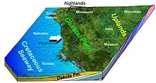
Beginning in the Early Cretaceous, the Cretaceous Seaway spread south from what is now the Arctic Ocean and connected with a short northward extension from the Gulf of Mexico.[14] This marine transgression of the ocean onto what was formerly land, was completed by the late Albian (~100 MA) thereby dividing North America in half. On the eastern side of the Seaway, sediments that would become the Dakota Formation were deposited as coastal and nearshore marine sands and silts. As the seaway continued to deepen and widen, this eastern shoreline moved progressively eastward throughout the Cenomanian. Meanwhile, on the western side of the seaway, sediments were carried eastwards and northeastwards by rivers from mountains located along what is the Nevada-Utah border.
These western sediments accumulated as nearshore and coastal sands and silts as well, and are counterparts to the Dakota Formation on the eastern side of the Seaway. However, these counterpart sediments originated from the other side of the sea and were carried by rivers flowing in opposite directions. These western sediments are equivalent to the Dakota Formation of the Great Plains, but are not exactly the same strata. Individual formations in the western Dakota Group have local names. In Wyoming, the term Cloverly Formation has been expanded by some authors to include sediments formerly placed within the Dakota Formation. Along the Colorado Front Range, the lower, terrestrial beds, or facies, of the Dakota Group are sometimes called the Lytle Formation, and near-shore marine facies are called the South Platte Formation.[15] In eastern Utah and western Colorado, Young introduced the term Naturita Formation for a series of facies in the larger "Dakota Group".[13] However, despite Witzke and Ludvigson logic, geologist have continued to refer to the Lower Cretaceous sequence of formations on the Colorado Plateau and the Rocky Mountains as the Dakota Group.[16]
Economic geology
The Dakota has provided several resources in the Plains states as well as in parts of the mountainous west.
The predominant shales and mudstones are a source of hydrocarbons while the lenses and channels of sandstone form exploitable hydrocarbon reserves. Thus, the Dakota Group is an oil and gas source in the Denver Basin.[17]
When they are near the surface, these same structures function as aquitards and aquifers, respectively. The Dakota sandstones form crucial supplies of water on the Plains, especially on uplands between river valleys wherever it is found outside the boundaries of the Ogallala Aquifer.[18]
.jpg.webp)
As the formation is uniquely terrestrial in origin, in contrast to the vast marine formations of the Plains, the Dakota has additional unique resources. Lignite coal has formed in the unit and was mined briefly in the 19th century. This supply was immediately mined for fuel by early American settlers, but was decidedly inferior to larger supplies of coal in the southeast of Kansas.[19] The widespread bog environments of the Dakota period resulted in concretions of iron, forming hematite, limonite, and beds of "ironstone", which are common in the Janssen clay member of Kansas.[19] Smelting of this limited iron source was only briefly attempted in conjunction with the lignite mining. The iron-cemented sandstone was found to be a durable and colorful building material on the treeless 19th century Plains. Historic 1860s buildings of Fort Harker (Kansas) and Fort Larned are constructed of this stone. The Dakota clays are quarried for tile and brick manufacture.[20]
Uranium is also found concentrated in the Dakota sandstone where percolating uranium-rich water has deposited the mineral in the aquifers.[21]
Vertebrate paleofauna
Dinosaur fossils are very rare in the Dakota Formation and most of them come from Kansas. Some of them are found in Colorado. The most popular site for public viewing of Creteceous dinosaur fossils in Colorado is Dinosaur Ridge. The best specimen is a partial skeleton of a nodosaurid ankylosaur called Silvisaurus condrayi.[22][23] Other isolated ankylosaur material may also belong to Silvisaurus.[24] Fossil dinosaur tracks are also known and include theropod and ankylosaur.[24] A large ornithopod femur is known from Burt County, Nebraska as well as fossil dinosaur tracks from Jefferson County.[25][26]
- cf. Troodon sp
- cf. Paronychodon (? troodontid indet)
- cf. Richardoestesia sp. (theropod indet)
- ? Barosaurus lentus
- Silvisaurus condrayi – "Partial skeleton with skull, sacrum."[27]
Pterosaurs
| Pterosaurs of the Dakota Formation | ||||
|---|---|---|---|---|
| Taxon | Presence | Description | Images | |
Suborder:
|
Known from both early and late Cretaceous strata in the Dakota Group.[28] Found at the John Martin Reservoir in Colorado.[28] | Specimens kept at the Dinosaur Tracks Museum, of the University of Colorado at Denver.[28] | ||
See also
- List of dinosaur-bearing rock formations
- Dinosaur Ridge is located west of Denver, Colorado
- Dakota Hogback
References
- "Geologic Unit: Woodbury". National Geologic Database. Geolex — Significant Publications. United States Geological Survey. Retrieved November 27, 2020.
- Molenaar, C.M., Cobban, W.A., Merewether, E.A., Pillmore, C.L., Wolfe, D.G., and Holbrook, J.M. (2002). "Regional stratigraphic cross sections of Cretaceous rocks from east-central Arizona to the Oklahoma Panhandle". National Geologic Map Database. USGS. Retrieved November 27, 2020.CS1 maint: uses authors parameter (link)
- "Geologic Unit: Dakota". National Geologic Database. Geolex — Significant Publications. United States Geological Survey. Retrieved November 27, 2020.
- Meek, F.B. and Hayden, F.V., 1862, Descriptions of new Lower Silurian, (Primordial), Jurassic, Cretaceous, and Tertiary fossils, collected in Nebraska, by the exploring expedition under the command of Capt. Wm F. Reynolds, U.S. Top. Engineers, with some remarks on the rocks from which they were obtained: Academy of Natural Sciences of Philadelphia Proceedings, v. 13, p. 415-447.
- Monroe, James S. and Wicander, Reed (1997) The Changing Earth: Exploring Geology and Evolution (2nd edition) Wadsworth Publishing Company, Belmont, California, page 610, ISBN 0-314-09577-2
- "Geology of the Quarry: Dakota Sandstone" Dinosaur National Monument, National Park Service
- McLaughlin, Thad G. (1942) "Water-bearing Formations, continued: Cretaceous System: Dakota Group" Geology and Ground-Water Resources of Morton County, Kansas
- Molenaar, C.M., Cobban, W.A., Merewether, E.A., Pillmore, C.L., Wolfe, D.G., and Holbrook, J.M. (2002). "Regional stratigraphic cross sections of Cretaceous rocks from east-central Arizona to the Oklahoma Panhandle". National Geologic Map Database. USGS. Retrieved November 27, 2020.CS1 maint: uses authors parameter (link)
- Jeremy McCreary. "Colorado Geology Photojournals - A Tribute to Colorado's Physical Past and Present - Colorado Geology Overview". cliffshade. Retrieved August 30, 2019.
- Wang, Herb (2003) "Saga of the Dakota Sandstone"
- Bejnar, C. R. and Lessard, R. H. (1976) "Paleocurrents and depositional environments of The Dakota Group, San Miguel and Mora Counties, New Mexico" in Ewing, Rodney C. and Kues, Barry S. (eds.) (1976) Guidebook of Vermejo Park, Northeastern New Mexico: Twenty-seventh Field Conference, September 30, October 1 and 2, 1976 New Mexico Geological Society, Socorro, N.M., pp. 157–163, OCLC 2754478
- Witzke, B.J., and Ludvigson, G.A. 1994. The Dakota Formation in Iowa and its type area. In Shurr, G.W., Ludvigson, G.A., and Hammond, R.H. (eds). Perspectives on the eastern margin of the Cretaceous Western Interior Basin. Geological Society of America, Special Paper 287:43–78.
- Young, Robert G. (1960) "Dakota Group of Colorado Plateau" American Association of Petroleum Geologists Bulletin 44(2): pp 156–194
- Kauffman, E.G. 1984. Paleobiogeography and evolutionary response dynamic in the Cretaceous Western Interior Seaway of North America. In Westermann, G.E.G. (ed), Jurassic-Cretaceous Biochronology and Paleogeography of North America, Geological Association of Canada Special Paper 27: 273–306.
- Waage, K. M. (1955) Dakota Group in northern Front Range Foothills, Colorado U.S. Geological Survey Professional Paper 274-B:15–49.
- For example in east-central and northeast New Mexico the Dakota Group cpnsists of the Mesa Rica Sandstone, the Pajarito Shale, and the Romeroville Sandstone, and includes the underlying Tucumcari Shale in the Tucumcari area and Glencairn Formation in Union County. "Dakota Group" U.S. Geological Survey
- Debra K. Higley and Dave O. Cox (2007). "Petroleum Systems and Assessment of Undiscovered Oil and Gas in the Denver Basin Province, Colorado, Kansas, Nebraska, South Dakota, and Wyoming—USGS Province 39 : Chapter 2 Oil and Gas Exploration and Development along the Front Range in the Denver Basin of Colorado, Nebraska, and Wyoming" (PDF). U.S. Department of the Interior / U.S. Geological Survey: 3. Retrieved April 19, 2020. Cite journal requires
|journal=(help) - Alvin R. Leonard and Delmar W. Berry, U. S. Geological Survey (1961). "Geology and Ground-water Resources of Southern Ellis County and Parts of Trego and Rush Counties, Kansas". State Geological Survey of Kansas Bulletin 149. University of Kansas. Retrieved April 19, 2020.
- Walter H. Schoewe (1952). "Coal Resources of the Cretaceous System (Dakota Formation) in Central Kansas". Kansas Geological Survey, Bulletin 96, Part 2. University of Kansas. Retrieved April 19, 2020.
- "Welcome to Kansas Brick and Tile". Retrieved April 19, 2020.
Our three brick plants are nestled in the Dakota clay deposits right here in the heart of Kansas.
- Dr. John Hopkins (August 14, 2018). "Geology of Uranium Deposits in Colorado". Retrieved April 19, 2020.
- Eaton, T.H. 1960. A new armored dinosaur from the Cretaceous of Kansas. University of Kansas Paleontological Contributions, Vertebrata, 8:1–24.
- Carpenter, K. and J.I. Kirkland. 1998. Review of Lower and Middle Cretaceous ankylosaurs from North America. Lucas, S.G., Kirkland, J.I. and Estep, J.W., (eds.), Lower and Middle Cretaceous Terrestrial Ecosystems. New Mexico Museum of Natural History and Science Bulletin No. 14:249–270.
- Liggett, G.A. 2005. A review of the dinosaurs from Kansas. Transactions of the Kansas Academy of Science 108(1–2), p.1-14.
- Barbour, E. H. 1931. Evidence of dinosaurs in Nebraska. Bulletin of University of Nebraska State Museum, 1:187–190.
- Joeckel, R. M., Cunningham, J. M., Corner, R. G., Brown, G. W., Phillips, P. L. and Ludvigson, G. A. 2004. Late Albian Dinosaur Tracks from the Cratonic (eastern) Margin of the Western Interior Seaway, Nebraska, USA. Ichnos, 11:275-284.
- "Table 17.1," in Weishampel, et al. (2004). Page 365.
- Lockley, M.; Harris, J.D.; and Mitchell, L. 2008. "A global overview of pterosaur ichnology: tracksite distribution in space and time." Zitteliana. B28. p. 187-198. ISSN 1612-4138.