Fruitland Formation
The Fruitland Formation is a geologic formation found in the San Juan Basin in the states of New Mexico and Colorado, in the United States of America. It contains fossils dating it to the Campanian age of the late Cretaceous.[2]
| Fruitland Formation Stratigraphic range: Campanian[1] ~76.3–75 Ma | |
|---|---|
 Fruitland Formation at the Bisti Wilderness | |
| Type | Geological formation |
| Sub-units | Fossil Forest Member Ne-nah-ne-zad Member |
| Underlies | Kirtland Formation |
| Overlies | Pictured Cliffs Sandstone |
| Lithology | |
| Primary | Sandstone |
| Other | Shale, coal |
| Location | |
| Coordinates | 36.752°N 108.442°W |
| Approximate paleocoordinates | 43.5°N 79.6°W |
| Region | |
| Country | |
 Fruitland Formation (the United States) 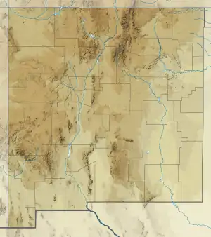 Fruitland Formation (New Mexico) | |
Description
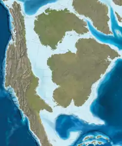
The Fruitland Formation is a sedimentary geological formation containing layers of sandstone, shale, and coal. It was laid down in marshy delta conditions, with poor drainage and frequent flooding, under a warm, humid and seasonal climate.
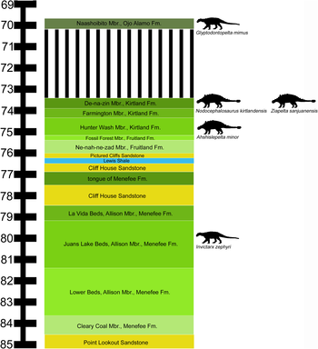
The Fruitland is underlain by the Pictured Cliffs Sandstone, and overlain by the more recent Kirtland Formation. The sequence of rocks represents the final filling of the Cretaceous seaway. The underlying Pictured Cliffs is a marginal marine sandstone, deposited in an environment similar to offshore barrier islands of the southeast United States. As the seaway retreated, the Pictured Cliffs was covered by the Fruitland Formation, which was deposited in near-shore swampy lowlands. The formation is dated to the late Campanian (part of the Cretaceous period), and was deposited over a period of about a million years. Radiometric dating from 23 meters above the base of the formation has yielded an age of 76.03 ± 0.41 Ma ago. An ash bed lying above the upper boundary with the Kirtland Formation has been dated to 75.02 ± 0.13 Ma ago. The underlying Pictured Cliffs Sandstone would be dated 76.94 - 76.27 Ma, based on the presence of the ammonite Baculites scotti, therefore placing the base of the Fruitland Formation at ~76.3 Ma.[3]
The formation is subdivided into the upper Fossil Forrest Member (deposited between about 75.5-75 million years ago) and the lower Ne-nah-ne-zad Member (deposited from 76.3-75.5 million years ago). The Fossil Forrest member is considered to be part of the Hunter Wash, fauna shared with the overlying lower Kirtland Formation.[1]
Paleofauna
Ornithischians
| Ornithischians of the Fruitland Formation | ||||||
|---|---|---|---|---|---|---|
| Genus | Species | Location | Member | Abundance | Notes | Images |
| Hadrosauridae indet.[4] | Intermediate[4] | Fossil Forest[4] | One print[4] | Giant hadrosaur track, indicating an individual larger than Shantungosaurus, the largest known hadrosaur.[4] | ||
| Parasaurolophus[5] | P. cyrtocristatus[5] | Fossil Forest[6] | One specimen, holotype |  | ||
| Pentaceratops[5] | P. fenestratus[5] | Junior synonym of P. sternbergii[5] | 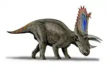 | |||
| P. sternbergii[5] | Fossil Forest[7] | Specimens including holotype | Also found in the Kirtland Formation | |||
| Stegoceras[8] | S. novomexicanum[8] | Fossil Forest[8] | "(holotype) NMMNH P-33898, nearly complete frontoparietal" and "SMP VP-2555, greater posterior part of left frontal and anterior-most portions of left and right frontals"[8] | Also found in the lower Kirtland Formation | 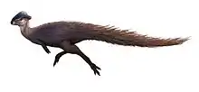 | |
Saurischians
Some remains (OMNH 10131) of Bistahieversor may actually have originated in the upper Fruitland Formation.[9]
| Saurischians of the Fruitland Formation | ||||||
|---|---|---|---|---|---|---|
| Genus | Species | Location | Member | Abundance | Notes | Images |
| Bistahieversor[9] | B. sealeyi | Fossil Forest | Rostral ramus of a right lacrimal | A large eutyrannosaur, similar to tyrannosaurids. |  | |
| Dromaeosauridae[1] | Indeterminate[1] | Teeth[1] | ||||
| Ornithomimidae[1] | Indeterminate[1] | |||||
| ?Troodontidae[5] | Indeterminate | Formerly identified as Paronychodon sp., referral to Troodontidae doubtful.[10] | ||||
Color key
|
Notes Uncertain or tentative taxa are in small text; |
Economic geology
The Fruitland Formation contains beds of bituminous coal that are mined in places along the outcrop. Since the 1980s, the coal beds of the Fruitland Formation have yielded large quantities of coalbed methane. The productive area for coalbed methane straddles the Colorado-New Mexico state line, and is one of the most productive areas for coalbed methane in the United States.
The methane released from the Fruitland Formation, through oil and gas production and a bit of natural seepage, contributes to the Four Corners Methane Hot Spot.[11][12]
See also
References
- Sullivan, R.M., and Lucas, S.G. 2006. "The Kirtlandian land-vertebrate "age" – faunal composition, temporal position and biostratigraphic correlation in the nonmarine Upper Cretaceous of western North America." New Mexico Museum of Natural History and Science, Bulletin 35:7-29.
- Fruitland Formation at Fossilworks.org
- Fowler, Denver Warwick (2017-11-22). "Revised geochronology, correlation, and dinosaur stratigraphic ranges of the Santonian-Maastrichtian (Late Cretaceous) formations of the Western Interior of North America". PLOS One. 12 (11): e0188426. doi:10.1371/journal.pone.0188426. ISSN 1932-6203. PMC 5699823. PMID 29166406.
- Hunt & Lucas (2003): A New Hadrosaur Track from the Upper Cretaceous Fruitland Formation of Northwestern New Mexico. 379 New Mexico Geological Society Guidebook, 54th Field Conference, Geology of the Zuni Plateau, 2003, p. 379-381.
- "3.3 New Mexico, United States; 7. Fruitland Formation," in Weishampel, et al. (2004). Page 580.
- Hunt, A. P., & Lucas, S. G. (2003). Origin and stratigraphy of historic dinosaur quarries in the Upper Cretaceous Fruitland Formation of the Fossil Forest research Natural Area, northwestern New Mexico. New Mexico Geological Society Guidebook, 54, 383-388.
- "Kirtlandian Index Fossils," in Sullivan and Lucas (2006). Page 10.
- Steven E. Jasinski and Robert M. Sullivan (2011). "Re-evaluation of pachycephalosaurids from the Fruitland-Kirtland transition (Kirtlandian, late Campanian), San Juan Basin, New Mexico, with a description of a new species of Stegoceras and a reassessment of Texascephale langstoni" (PDF). Fossil Record 3. New Mexico Museum of Natural History and Science, Bulletin. 53: 202–215.CS1 maint: uses authors parameter (link)
- Carr, T.D. and Williamson, T.E. (2010). "Bistahieversor sealeyi, gen. et sp. nov., a new tyrannosauroid from New Mexico and the origin of deep snouts in Tyrannosauroidea." Journal of Vertebrate Paleontology, 30(1): 1-16. doi:10.1080/02724630903413032
- David C. Evans, Derek William Larson, Thomas Michael Cullen & Robert M Sullivan (2014) ‘Saurornitholestes’ robustus is a troodontid (Dinosauria: Theropoda). Canadian Journal of Earth Sciences 51: (7): 730-734. doi: 10.1139/cjes-2014-0073 http://www.nrcresearchpress.com/doi/abs/10.1139/cjes-2014-0073
- Fenton, James (May 12, 2016). "Geologist: Coal outcrops cause methane hot spot". Farmington Daily Times. Retrieved 2019-12-21.
- Elliott, Dan (2016-08-15). "Methane "hot spot" over Four Corners linked to oil, gas production sites". The Denver Post. Retrieved 2019-12-21.
Bibliography
- Weishampel, David B.; Peter Dodson, and Halszka Osmólska (eds.). 2004. The Dinosauria, 2nd edition, 1–880. Berkeley: University of California Press. Accessed 2019-02-21. ISBN 0-520-24209-2
