Greater Danbury
Greater Danbury, also known as the Housatonic Valley Region, is a region in the state of Connecticut centered on the city of Danbury. It consists of the city of Danbury and adjacent towns in the areas around the Housatonic River and the Still River.[2]
Greater Danbury | |
|---|---|
 | |
| Country | United States |
| State(s) | Connecticut |
| Largest city | Danbury |
| Area | |
| • Total | 430.8 sq mi (1,116 km2) |
| Population (2015) | |
| • Total | 264,621[1] |
| • Rank | 185th in the U.S. |
| • Density | 1,400.3/sq mi (540.6/km2) |
| Time zone | UTC−05:00 (Eastern Standard Time) |
| • Summer (DST) | UTC−04:00 (Eastern Daylight Time) |
Definitions
New England City and Town Area
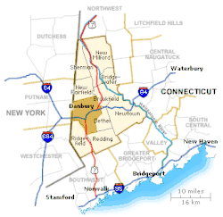
The U.S. Census Bureau defines the metropolitan area of Danbury as the Danbury NECTA.[3] It consists of the city of Danbury plus the towns of Bethel, Bridgewater, Brookfield, New Fairfield, New Milford, Newtown, and Sherman for a total of eight towns.[4] As of the 2015, the population of the Danbury NECTA was 264,621. Although Redding and Ridgefield border The City of Danbury, they are technically classified within the NECTA's Bridgeport-Stamford-Norwalk-Danbury area (which encompasses the region including Danbury).
Western Connecticut Region
The Danbury NECTA is located within the area administered by the Western Connecticut Council of Governments, and is part of the Housatonic Valley Metropolitan Planning Organization.[5][6]
Danbury Labor Market Area
As defined by the Bureau of Labor Statistics, the labor market area of Danbury includes the towns in the Housatonic Valley Region plus the towns of Roxbury and Washington for a total of twelve towns.
References
- https://www.westernconnecticuthealthnetwork.org/~/media/wchn/shared/files/community-benefit/2016-greater-danbury-region-community-health-needs-assessment.pdf?la=en Greater Danbury Needs Assessment
- https://www.danburychamber.com/community/about-danbury/ Area defined as "Greater Danbury"
- https://www.census.gov/geo/www/guidestloc/files/necta10.txt
- http://www.bos.frb.org/commdev/data-resources/LMIProfiles/PDFs/Danbury.pdf
- https://westcog.org/ Western Connecticut Council of Governments
- https://westcog.org/meetings/mpos/hvmpo/ Housatonic Valley Metropolitan Planning Organization
External links