Hathras
Hathras is a city and a municipal board in the Hathras district in Uttar Pradesh, India. The district was formed on 3 May 1997 by merging parts of Aligarh, Mathura, Agra. It represents a part of the Aligarh Division.[2]
Hathras | |
|---|---|
City | |
 Hathras | |
| Coordinates: 27.60°N 78.05°E | |
| Country | India |
| State | Uttar Pradesh |
| District | Hathras |
| Government | |
| • Type | Democratic |
| Area | |
| • Total | 142 km2 (55 sq mi) |
| Elevation | 178 m (584 ft) |
| Population (2011)[1] | |
| • Total | 160,909 |
| • Density | 1,133/km2 (2,930/sq mi) |
| Languages | |
| • Official | Hindi, Urdu |
| Time zone | UTC+5:30 (IST) |
| PIN | 204101 |
| Telephone code | 05722 |
| Vehicle registration | UP-86 |
| Sex ratio | 870 ♂/♀ |
| Website | hathras |
The primary spoken language is a dialect of Hindi, Braj Bhasha, which is closely related to Khariboli, one of, several dialects spoken in the Delhi region.[3] Famous for asafoetida (aka hing), Hathras is the large scale producer of it for the last 100 years.[4]
Administration
Hathras is a district headquarter with three subdivisions - Hathras, Sikandra Rao, and Sadabad. It is a Lok Sabha constituency under the reserved category of Schedule Caste. The district has three assembly constituencies, following three subdivisions. The Hathras district, formerly known as Mahamaya Nagar, was created in 1997 with the incorporation of parts of the Aligarh, Mathura, and Agra districts.[5]
Geography
Hathras is located at 27.6°N 78.05°E.[8] It has an average elevation of 185 metres (606 feet) and is situated on the Agra, Aligarh and Mathura, and Bareilly highway crossings. It is known for its extreme temperature variations.[9] As of the 2001 Indian census, Hathras had a population of 123,243. with a gender distribution is 53% male and 47% female. Hathras has an average literacy rate of 60%, higher than the national average of 59.5%, of which 66% being male and 53% being female. 14% of the population is under six years of age.
| City | Distance from Hathras town | Direction from Hathras town |
|---|---|---|
| Aligarh | 36 km | Towards the north |
| Mathura | 41 km | Towards the west |
| Khair | 46 km | Towards the northwest |
| Agra | 53.8 km | Towards the south |
The nearest railway station is the Hathras Junction Railway Station, located at 10 km from the center of Hathras.
Climate
Hathras has a monsoon-influenced humid subtropical climate, typical of north-central India. Summers start in April ending around May. The monsoon season starts in late June, continuing till early October, bringing high humidity.[10]
| Climate data for Hathras | |||||||||||||
|---|---|---|---|---|---|---|---|---|---|---|---|---|---|
| Month | Jan | Feb | Mar | Apr | May | Jun | Jul | Aug | Sep | Oct | Nov | Dec | Year |
| Average high °F (°C) | 71.6 (22.0) |
82.0 (27.8) |
92.1 (33.4) |
102.2 (39.0) |
108.7 (42.6) |
104.0 (40.0) |
95.0 (35.0) |
93.2 (34.0) |
96.6 (35.9) |
94.1 (34.5) |
73.4 (23.0) |
76.1 (24.5) |
114.1 (45.6) |
| Average low °F (°C) | 47.5 (8.6) |
53.6 (12.0) |
62.8 (17.1) |
72.3 (22.4) |
82.0 (27.8) |
85.1 (29.5) |
81.0 (27.2) |
78.8 (26.0) |
70.7 (21.5) |
73.4 (23.0) |
50.2 (10.1) |
44.6 (7.0) |
45.5 (7.5) |
| Source: India Meteorological Department[11][12] | |||||||||||||
Transport
Four railway stations serve Hathras: Hathras Junction railway station, Hathras Road railway station,[13] Hathras City railway station, and Hathras Kila railway station. A new station on the dedicated Freight Corridor Line was named New Hathras.
Hathras is the only city in the area to have five railway stations named after it.
History
Hathras became a district on 6 May 1997 with the merging of some Tehsils of Aligarh and Mathura.[14] Hathras falls under the Braj region of Northern India and is famous for its industrial, literary, and cultural activities as a part of Aligarh.[15]
Historically and according to Puranas, Hathras can be of the age of Mahabharata. Hathras was an industrial hub during the British Raj. It was known for its cotton mills, asafoetida and desi ghee industries. The cotton milled here was exported around the world.
The Freedom Struggle started by Raja Dayaram (Jat King of Hathras during British Raj) continued until India became free in which many people of Hathras participated. It is famous for its industrial, literary, and cultural activities as a part of Aligarh.[16]
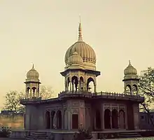
Place of Interest
Notable people
- Kaka Hathrasi (Poet)
References
- "Uttar Pradesh (India): State, Major Agglomerations & Cities – Population Statistics, Maps, Charts, Weather and Web Information". citypopulation.de. Retrieved 1 January 2021.
- "Akhilesh renames eight districts". Thehindu.com. 24 July 2012. Retrieved 6 January 2019.
- Scott, Jerrie Cobb; Straker, Dolores Y.; Katz, Laurie (2 June 2009). Affirming Students' Right to Their Own Language: Bridging Language Policies and Pedagogical Practices. Routledge. ISBN 978-1-135-26945-6.
- "Official Website of One District One Product Uttar Pradesh / Hathras". odopup.in. Retrieved 31 July 2020.
- "Administrative Setup | District Hathras, Government of Uttar Pradesh | India". Retrieved 13 May 2020.
- "LOCAL BODIES | District Hathras, Government of Uttar Pradesh | India". Retrieved 4 June 2020.
- https://hathras.nic.in/local-bodies/
- "Falling Rain Genomics, Inc - Hathras". Fallingrain.com. Retrieved 23 June 2012.
- "Weather for Hathras, Uttar Pradesh, India". Timeanddate.com. Retrieved 6 January 2019.
- "Hathras Monthly Climate Averages". WorldWeatherOnline.com. Retrieved 16 August 2020.
- "Extremes of Temperature & Rainfall for Indian Stations (Up to 2012)". India Meteorological Department. December 2019. p. M210. Archived from the original on 5 February 2020. Retrieved 27 April 2020.
- "Extremes of Temperature (From Jan 2020 to Aug 2020)". India Meteorological Department. 16 August 2020. p. M210. Archived from the original on 16 August 2020. Retrieved 16 August 2020.
- "Hathras Road Railway Station (HTJ) : Station Code, Time Table, Map, Enquiry". www.ndtv.com. Retrieved 25 May 2020.
- "About District | District Hathras, Government of Uttar Pradesh | India". Retrieved 25 May 2020.
- "Official Website of One District One Product Uttar Pradesh / Hathras". odopup.in. Retrieved 25 May 2020.
- http://odopup.in/