Hindutash
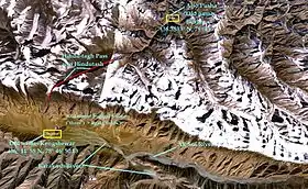
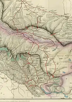
Hindutash, also known as Hindu-tagh Pass, is a historical mountain pass in the western Xinjiang, China. The pass cuts through the Kunlun Mountains connecting the now-deserted town of Kangxiwar in the Karakash River valley to the town of Pusha in the Yurungkash River valley (36.3833°N 79°E; formerly Bushia). It also connects to the road to the city of Hotan (formerly Khotan or Ilchi; see maps on right).[1]
| Hindutash Pass | |
|---|---|
 | |
| Elevation | 5,450 m (17,881 ft) |
| Traversed by | China National Highway 580 (under construction) |
| Location | Hotan County, Xinjiang, China |
| Range | Kunlun Mountains |
| Coordinates | 36°16′23″N 78°46′50″E |
| Hindutash | |||||||
|---|---|---|---|---|---|---|---|
| Traditional Chinese | 印地他什達坂 | ||||||
| Simplified Chinese | 印地他什达坂 | ||||||
| |||||||
China National Highway 580 is under construction connecting Kangxiwar directly with Hotan.[2] It will tunnel under Hindutash, connect with the Xinjiang-Tibet Highway G219 to the south after numerous hairpin turns.[3] It is scheduled to be completed in 2022.[4]
"Hindu-tagh" means "Indian Mountain," and "Hindu-tash," "Indian stone" in the Uyghur dialect of Xinjiang.
History
In 1857, the explorer Robert Schlagintweit crossed this pass from camping grounds in Sumgal ("three fords"), on the banks of the Karakash river, approximately 7 miles (11 km) upstream from Kengshewar and estimated its height to be 17,879 ft (5,450 m). At the top of the pass (36°16′23″N 78°46′50″E), there is a steep glacier with many crevasses. The eastern Kunlun range, which is in the southern region of the Hotan prefecture of Xinjiang, is cut by two other passes: the Sanju Pass, near the small staging post of Xaidulla, formerly Shahidulla, northwest of Hindu-tagh, and the Ilchi Pass, southeast of Hindu-tagh, just north-east of the village of Dahongliutan, itself just north of the now disputed Aksai Chin area (see second map on right). The former pass had been much used historically, and provided the traditional means of entry from the south into the ancient Kingdom of Khotan. The latter was traversed in 1865 by W. H. Johnson of the Survey of India.
Gallery
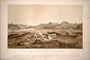 "The Chain of the Kuenlúen, from Súmgal, in Turkistán (Lat North 36° 8', Long. East of Green. 78° 5', Height 13, 215 Engl. feet)" by Hermann Schlagintweit, August 1856. Lithographed by Sabatier, printed in oil-colours by Lemereier, Paris. The Hindu-tagh Pass is the break in the mountains on the right.
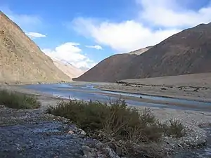 Yarkand River in the Western Kunlun Range, seen from the Xinjiang-Tibet Highway
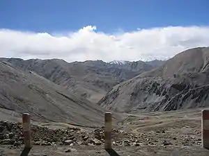 View of Western Kunlun Range from the Xinjiang-Tibet Highway
Maps
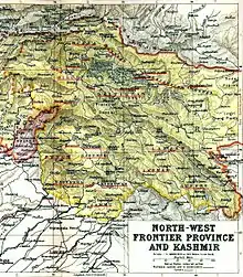 A lower-resolution 1909 Map of the Princely State of Kashmir and Jammu. Sumgal in the valley below the Hindu-tagh Pass is shown in the top right corner.
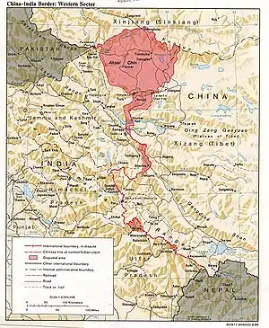
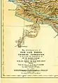 Map of Aurel Stein (1911) based on that of the Survey of India showing the "Hindutash Dawan" in the Kunlun Mountains
Notes
- (Trotter 1878, p. U8)
- Zeng, Tao-rui; Wang, Lin-feng (2019). "The Reliability and Stability Analysis of High Shear Slope in Cold Region Based on First Order Quadratic Matrix". Science Technology and Engineering. kns.ccpd.cnki.net (21). ISSN 1671-1815. Retrieved 7 January 2020.
Taking the K86 + 780 ~ K86 + 840 soil high cut slope of the highway section from Hetian to Kangxiwa of G580 line as an example,the reliability calculation of soil high cut slope in the cold region was carried out
- "新疆G580线和田至康西瓦公路PPP项目施工总承包指挥部" [Xinjiang G580 line Hotan to Kangxiwar road PPP project construction general contracting HQ] (in Chinese). gonglutielu.com. 2017-08-28. Retrieved 7 January 2020.
于印地他什达坂设隧道,出洞后沿等高线展线而下,最终与G219相接。
- 中国交通新闻网 (2019-11-18). "580国道和康项目一标完成路面摊铺" [G580 Hotan-Kangxiwar Project first milestone completed, road surface paved]. Ministry of Transport of the People's Republic of China. Retrieved 7 January 2020.
日前,580国道新疆和田至康西瓦公路项目一标主线沥青路面完成摊铺,为2022年全线通车奠定了坚实基础。
References
- Johnson, W. H. (1867), "Report on His Journey to Ilchí, the Capital of Khotan, in Chinese Tartary", Journal of the Royal Geographical Society of London, 37 (1): 1–47, doi:10.2307/1798517, JSTOR 1798517.
- Schlagintweit, Hermann; Schlagintweit, Adolphe; Schlagintweit, Robert (1861), Results of a Scientific Mission to India and High Asia: undertaken between the years MDCCCLIV and MDCCCLVIII, Leipzig/London: F. A. Brockhaus/Trubner and Co..
- Stein, M. Aurel (1909), "Explorations in Central Asia, 1906-8", The Geographical Journal, 34 (1): 5–36, doi:10.2307/1777985, JSTOR 1777985.
- Stein, M. Aurel (1911), "Note on Maps Illustrating Dr. Stein's Explorations in Chinese Turkestan and Kansu", The Geographical Journal, 37 (3): 275–280, doi:10.2307/1777400, JSTOR 1777400.
- Trotter, H. (1878), "On the Geographical Results of the Mission to Kashghar, under Sir T. Douglas Forsyth in 1873-74", Journal of the Royal Geographical Society of London, 48 (2): 173–234, doi:10.2307/1798763, JSTOR 1798763.
Mountain passes of China | |||||||||||||||
|---|---|---|---|---|---|---|---|---|---|---|---|---|---|---|---|
| On the border | |||||||||||||||
| In the interior |
| ||||||||||||||
| |||||||||||||||
