Kongka Pass
The Kongka Pass or Kongka La (Hindi: कोंग्का दर्रा; Chinese: 空喀山口; Standard Tibetan: དགུན་ཁ་ལ[2]) is a low mountain pass over a hill that intrudes into the Chang Chenmo Valley, which has become a key marker of the Line of Actual Control between India and China. China considers the Kongka Pass as its boundary with India, whereas India regards Lanak Pass further east as the boundary.[3] The pass was the location of the Kongka Pass incident, a military skirmish between Chinese and Indian patrol officers in 1959.
| Kongka La | |
|---|---|
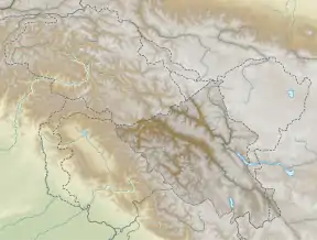 Location of Kongka La 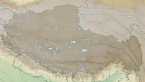 Kongka La (Tibet) | |
| Elevation | 5,171 m (16,965 ft)[1] |
| Location | India–China border |
| Range | Himalayas |
| Coordinates | 34°20′06″N 79°02′07″E |
| Kongka Pass | |||||||
|---|---|---|---|---|---|---|---|
| Chinese name | |||||||
| Traditional Chinese | 空喀山口 | ||||||
| Simplified Chinese | 空喀山口 | ||||||
| |||||||
| Tibetan name | |||||||
| Tibetan | དགུན་ཁ་ལ | ||||||
| |||||||
History
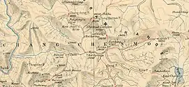
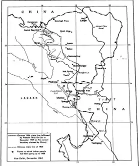
In the late 1800s, the pass was referred to as Salmu Kongka and described as a "small pass".[4] It was not a particularly important pass. The travel route followed the course of Chang Chenmo, which makes a slight bend around the hill that contains the pass. (See map.)
Colonial-era British sources state that the traditional boundary between Ladakh and Tibet was at Lanak La, where the Chang Chenmo River originates. They also state that the border was accepted by both sides.[5][6][7][8]
Chinese maps also recognised Lanak La as the boundary till 1951.[9] However, by late 1950s, Chinese premier Zhou Enlai started claiming that Kongka Pass was the "traditional customary boundary" of China.[10][11]
Scholars have pointed out the inconsistencies in Chinese claims prior to 1960s.[12][13][lower-alpha 2]
Kongka Pass incident
Until October 1959, China had not declared its border with Ladakh. When enquired in 1954 and again in 1956, the Chinese Premier Zhou En-lai replied that the PRC government was still printing Kuomintang maps and had not had the time to prepare their own maps. While maintaining this position, the Chinese laid the Sianking–Tibet road (now G219) through Aksai Chin and detained an Indian patrol party that was sent to investigate it.[16]
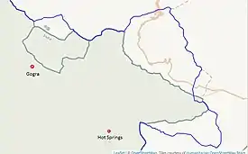
In matter of fact, the 1956 Chinese map (called the "Big map of the People's Republic of China") showed Kongka Pass as China's boundary in the Chang Chenmo Valley. The three locations, Tsogstsalu, Hot Springs and Shamal Lungpa, where an Indian police party was sent to set up posts in 1959, were on the Indian side of the boundary per this map.
The police party[lower-alpha 3] was led by an Intelligence Bureau officer, Karam Singh, who was an experienced patroller in Ladakh. He states that they had established a post at Hot Springs and were about to head to Shamal Lungpa. On 20 October, two men sent out for reconnaissance went missing.[17] According to the Chinese version of the events they are said to have crossed the Kongka Pass, which China now regarded as a border pass.[14]
On 21 October, with signs of Chinese presence becoming available, a larger search party of 20 men was formed for the missing reconnaissance team.[18][19] The men encountered Chinese soldiers at a hill near the Kongka Pass, and a firefight ensued. Chinese forces had a more favourable position in this engagement.[17] Nine Indian policemen were killed during the engagement, one died later of his injuries,[20] and seven were taken prisoner (totaling ten when including the reconnaissance team). One Chinese soldier was killed in the engagement.[17][21][22][23]
The Chinese detachment belonged to the 6th Cavalry Regiment.[24] The detained personnel were put in a storage pit for four days under several climatic condtions, interrogated in 12 hour stretches for further several days, made to sign false confessions, and finally window dressed for photographs and returned to India on 14 November. Scholar John Rowland states that, through these means, China obtained the evidence it needed to claim that it was India that broke the Panchsheel.[25]
Indian media described the event as a "brutal massacre of an Indian police party." The incident contributed to the heightening of tensions that led to the Sino-Indian War in 1962.[3][18]
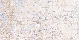
Military posts and infrastructure
The Indian border post is located 3 kilometres (1.9 mi) to the west at Hot Springs.[26]
The Chinese border outpost is located a few kilometers to the east at the elevation of 5,070 metres (16,630 ft).[27]
Called Kongka Shankou base, it is located at the junction of the Kyapsang and Chang-Chenmo rivers. It is linked to the China National Highway 219 (G219) via two highways.
- The Konghong Highway (空红线, S519), or Kongka–Hongshan Highway, runs along the Chang-Chenmo Valley via Lanak La, and meets G219 near the Sumzhi and Longmu lakes.[29]
- A new road called Kongka Shankou Highway (空喀山口公路) has been laid along the continuation of the same depression on the other side of G219, meeting the China National Highway 216 (G216) near the Yueya Lake.[29]
- The Banying Highway (班应线, S520) goes south to the Khurnak Plain on the bank of the Pangong Lake and runs on the northern shore of the lake till its eastern terminus.[30]
According to the Indian government, the original versions of these roads were built between 1959 and 1962.[31]
In addition to these, a Tiankong Highway (天空线) or Tianwendian–Kongka highway, appears to have been constructed between 2013 and 2020. It passes through territory marked as being on the Indian side of the Line of Actual Control by the US Office of the Geographer in 2013.[28] It is a mountain road that runs till the Tianwendian post in the Depsang Plains, running parallel to the Line of Actual Control in Askai Chin. It passes through Nischu and Heweitan, and also connects to the Wen Jia Way, which leads to the Galwan Valley.[32]
Notes
- From map: "THE DELINEATION OF INTERNATIONAL BOUNDARIES ON THIS MAP MUST NOT BE CONSIDERED AUTHORITATIVE"
- Some western scholars such as Larry Wortzel and Allen S. Whiting appear to endorse the Chinese claim.[14][15]
- The Indian team was made up of personnel from the Central Reserve Police Force (CRPF), who were loaned to the Intelligence Bureau for border security and intelligence-gathering functions. They were dubbed the "India–Tibet Border Force", but they are not to be confused with the paramilitary force called Indo-Tibetan Border Police, which was a later formation.
References
- "Kongka La". GeoNames. Retrieved 18 September 2013.
- "Ngari prefecture". Geographical names of Tibet AR (China). Institute of the Estonian Language. 3 June 2018. Retrieved 9 January 2020.
- Maxwell, Neville (1970). India's China War. New York: Pantheon. p. 13. Retrieved 29 August 2013.
- "Journey of Carey and Dalgleish in Chinese Turkistan and Northern Tibet and General Prejevalsky on the Orography of Northern Tibet", Royal Geographical Society (Great Britain), Supplementary Papers, J. Murray, 1893, p. 10 – via archive.org: Describing the route from Leh to Keriya: "Leaving [Changchenmo valley] shortly after the Shahidulla road turns off to the left, it ascends to the plateau by a small pass (the Salmu Kongka); descending again into the valley and crossing the Changchenmo stream. Another ascent leads up the Lanak-la Pass, and the route now lies in independent Tibet."}}
- Wellby, M.S. (1898). Through Unknown Tibet. Lippincott. p. 78. ISBN 9788120610583.
- Carey, A. D. (1887). "A Journey round Chinese Turkistan and along the Northern frontier of Tibet". Proceedings of the Royal Geographic Society. 9 (12): 731–752. doi:10.2307/1801130. JSTOR 1801130.
- Bower, Hamilton, Diary of A Journey across Tibet, London, 1894
- Rawling, C. G., The Great Plateau Being An Account of Exploration in Central Tibet, 1903, And of the Gartok Expedition 1904–1905, p 38, London, 1905
- Karackattu, Joe Thomas (2020). "The Corrosive Compromise of the Sino-Indian Border Management Framework: From Doklam to Galwan". Asian Affairs. 51 (3): 590–604. doi:10.1080/03068374.2020.1804726. S2CID 222093756.: "Figure 1. Galwan river area shown as part of India as per Chinese official maps from 1934 and 1951 (note the arrow insert placed to indicate the area); depicted subsequently outside of India. Clockwise (a) Chung hua min kuo hsin titu 中华民国新地图 (A New Atlas of China), 1934 (b) 1951 Atlas of China was one of the earliest official maps published by the PRC accredited by the Zhongguo Tushu Faxing Gongsi (akin to internal security department) (c) The 1959 ‘Line of Actual’ control, according to Zhou Enlai (周恩来) in The Sino-Indian Boundary Question (Enlarged Edition), Foreign Languages Press, Peking, November 1962."
- Karackattu, Joe Thomas (2020). "The Corrosive Compromise of the Sino-Indian Border Management Framework: From Doklam to Galwan". Asian Affairs. 51 (3): 590–604. doi:10.1080/03068374.2020.1804726. S2CID 222093756.
- Chou Enlai, The Sino-Indian Boundary Question, Foreign Language Press, Peking, November 1962. "In October 1959 Indian armed forces crossed the traditional customary boundary line in the western sector and provoked a sanguinary border clash of an even graver nature at Kongka Pass." (emphasis added)
- Fisher, Rose & Huttenback, Himalayan Battleground (1963), p. 101: "Confusion as to the extent of the Chang Chenmo valley between the Lanak and Kongka passes continued to be a feature of Chinese cartography even after the Communists came to power.... the flexibility shown by official Chinese cartographers here and on other sections of the border makes mockery of China's oft-repeated claim that its concept of the border has a solid basis in history."
- Van Eekelen, Willem Frederik (1967), Indian Foreign Policy and the Border Dispute with China, Springer, p. 164, ISBN 978-94-017-6555-8,
The Chinese could not quote a single document confirming that the Kongka Pass constituted the boundary.... The thorough approach of the Indian side generally contrasted with an inconsistent and almost careless presentation by the Chinese officials.
- Wortzel, Larry (2003). Burkitt, Laurie; Scobell, Andrew; Wortzel, Larry (eds.). The Lessons of History: The Chinese People's Liberation Army at 75 (PDF). Strategic Studies Institute, U.S. Army War College. p. 331. ISBN 9781428916517.
"In the western sector of the border, on 21 October 1959, a team of Indian troops crossed the traditional border at Kongka Pass, entering Chinese territory." (emphasis added)
- Whiting, Allen S. (1987). "The Sino-Soviet Split". In MacFarquhar, Roderick; Fairbank, John K. (eds.). The Cambridge History of China, Volume 14. Cambridge University Press. p. 512. ISBN 978-0-521-24336-0.
More dead resulted, however, on 21 October, from fighting at Kongka Pass, at the trijuncture of Tibet, Sinkiang, and Ladakh, where nine Indians were killed and ten taken prisoner.
- Smith, Warren W. (1996), Tibetan Nation: A history of Tibetan nationalism and Sino-Tibetan relations, Westview Press, p. 489, ISBN 978-0-8133-3155-3,
Chou had assured Nehru that the PRC was still using old KMT maps, not yet having had time to prepare their own... On 8 October 1958 the Indians protested to China that the [Sinkiang-Tibet road] traversed Indian territory, to which the PRC replied that the territory in question was Chinese.
- "Notes, Memoranda and letters Exchanged and Agreements signed between The Governments of India and China" (PDF). White Paper III. Ministry of External Affairs, Government of India. November 1960 – March 1960. Retrieved 4 January 2020 – via Claude Arpi.
[Chinese interrogation of Karam Singh] We established a checkpost at Kayam and we had to establish one at Shamul Lungpa. On 20th October, 1959, our two men missed. On the morning of 21st October 1959 Tyagi took 60 men and reached the hill (battle field). ... [Indian debriefing of Karam Singh] we had inadequate cover and the Chinese were in a favourable position ... five of us were made to carry the dead body of a Chinese soldier who had been killed.
- Vivek Ahuja. "Unforgiveable Mistakes, The Kongka-La Incident, 21st October 1959" (PDF). Archived from the original (PDF) on 30 September 2011. Retrieved 2 November 2011.
- Sandhu, Shankar & Dwivedi, 1962 from the Other Side of the Hill (2015), p. 44.
- Bhatnagar, R.R. (November–December 2018). "Hot Springs: Saga of Heroism" (PDF). Indian Police Journal. No. Special Issue on Police Martyrdom. p. 16. ISSN 0537-2429. Retrieved 4 January 2020.
Fighting gallantly nine men laid down their lives and ten were wounded. Later on, one of the injured also succumbed to his injuries. ... Seven men were taken Prisoners of War by PLA
- Chinese People's Liberation Army Historical Data Series Editorial Board (1997). Communist Remembrance Historical Materials 3. Beijing:解放军出版社. p. 213. ISBN 7-5065-3348-0.
- Naifu, Cui, ed. (2002). The People's Republic of China's Toponymic Dictionary Volume 5. Beijing:商印书. p. 7777. ISBN 7-100-03254-7.
- "Shuol government information website--Shule County Martyrs Cemetery Maintenance and Reconstruction Project successfully passed the project completion acceptance". Silele County People's Government. Archived from the original on 7 May 2018. Retrieved 6 May 2018.
- Sandhu, Shankar & Dwivedi, 1962 from the Other Side of the Hill (2015).
- Rowland, A History of Sino-Indian Relations (1967), pp. 130–131: 'Singh's testimony provides a good picture of Chinese interrogating technique: "This interrogation lasted from 4:00 A.M. to about 4:00 P.M. By this time I was almost frozen and mentally and physically exhausted because of cold, persistent interrogation, intimidation, threats, angry shoutings and lack of sleep. In this condition I was compelled to sign the statement recorded by the Chinese. At the end of this interrogation the Chinese then brought all the other captured personnel before me and read out the statement and several photographs were taken."... The incident was staged according to the Chinese version of events while photographs were taken which could be used as evidence in support of the Chinese allegations that the Indian patrol had provoked the incident.'
- Jindal, Akash (November–December 2018). "The Story of Hot Springs" (PDF). Indian Police Journal. No. Special Issue on Police Martyrdom. pp. 20–33. ISSN 0537-2429. Retrieved 4 January 2020.
(p22) Karam Singh of ITBF was assigned the task of establishing outposts near the Chinese Occupation Line ... "Hot Springs" was barely three Km far from the site where Chinese Army had intruded.
- "在海拔5070米的空喀山口哨卡某边防团政委宗建明和官兵深情的拥抱". Sina Military (in Chinese). 17 September 2009. Retrieved 14 December 2019.
- Detailed World Polygons (LSIB), Asia and Russia, 2013, EarthWorks, Stanford University
- Konghong Highway (China, S519) and Kongka Shankou Highway mapped on OpenStreetMap, retrieved 22 October 2020.
- Bangying Highway (China, S520) mapped on OpenStreetMap, retrieved 22 October 2020.
- India, Government of (January 1963), Chinese Aggression in Maps (PDF), Publications Division, Map 4
- Tiankong Xian and Wen Jia Road mapped on OpenStreetMap, retrieved 22 October 2020.
Bibliography
- Fisher, Margaret W.; Rose, Leo E.; Huttenback, Robert A. (1963), Himalayan Battleground: Sino-Indian Rivalry in Ladakh, Praeger – via archive.org
- Rowland, John (1967), A History of Sino-Indian Relations: Hostile Co-existence, Van Nostrand
- Sandhu, P. J. S.; Shankar, Vinay; Dwivedi, G. G. (2015), 1962: A View from the Other Side of the Hill, Vij Books India Pvt Ltd, ISBN 978-93-84464-37-0
External links
- Konghong Highway (China, S519) and Kongka Shankou Highway mapped on OpenStreetMap
- Bangying Highway (China, S520) mapped on OpenStreetMap
- Tiankong Xian connecting Tianwendian and Kongka La, mapped on OpenStreetMap
- Route to Hot Springs (India), mapped on OpenStreetMap
Mountain passes of China | |||||||||||||||
|---|---|---|---|---|---|---|---|---|---|---|---|---|---|---|---|
| On the border | |||||||||||||||
| In the interior |
| ||||||||||||||
| |||||||||||||||
| History |
| ||||||||||||||||||
|---|---|---|---|---|---|---|---|---|---|---|---|---|---|---|---|---|---|---|---|
| Administration | |||||||||||||||||||
| Geography |
| ||||||||||||||||||
| Human settlements | |||||||||||||||||||
| Culture |
| ||||||||||||||||||
| Tourism and wildlife |
| ||||||||||||||||||
| Transport |
| ||||||||||||||||||
| Infrastructure |
| ||||||||||||||||||
| See also |
| ||||||||||||||||||
