Laurens County, Georgia
Laurens County is a county located in the U.S. state of Georgia. As of the 2010 census, the population was 48,434.[1] The county seat is Dublin.[2] The county was founded on December 10, 1807, and named after Lieutenant Colonel John Laurens,[3] an American soldier and statesman from South Carolina during the American Revolutionary War.
Laurens County | |
|---|---|
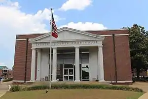 Laurens County Courthouse in Dublin | |
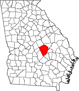 Location within the U.S. state of Georgia | |
 Georgia's location within the U.S. | |
| Coordinates: 32°28′N 82°56′W | |
| Country | |
| State | |
| Founded | December 10, 1807 |
| Named for | John Laurens |
| Seat | Dublin |
| Largest city | Dublin |
| Area | |
| • Total | 818 sq mi (2,120 km2) |
| • Land | 807 sq mi (2,090 km2) |
| • Water | 11 sq mi (30 km2) 1.4%% |
| Population | |
| • Estimate (2018) | 47,325 |
| • Density | 60/sq mi (20/km2) |
| Time zone | UTC−5 (Eastern) |
| • Summer (DST) | UTC−4 (EDT) |
| Congressional district | 12th |
| Website | www |
Laurens County is part of the Dublin, Georgia Micropolitan Statistical Area.
History
Laurens County was formed on December 10, 1807, from portions of Wilkinson and Washington counties.[4] During the Red Summer of 1919 there was increased racial tension in the area and in August there was the Laurens County, Georgia race riot of 1919.
Geography
According to the U.S. Census Bureau, the county has a total area of 818 square miles (2,120 km2), of which 807 square miles (2,090 km2) is land and 11 square miles (28 km2) (1.4%) is water.[5] It is the third-largest county in Georgia by land area and fourth-largest by total area.
The majority of Laurens County is located in the Lower Oconee River sub-basin of the Altamaha River basin. The southwestern corner of the county, defined by a line that runs west from Chester through Rentz to U.S. Route 441, and then southeast toward Glenwood, is located in the Little Ocmulgee River sub-basin of the same Altamaha River basin. A small and narrow sliver of the eastern edge of the county, from east of Lovett to northeast of Rockledge, is located in the Ohoopee River sub-basin of the larger Altamaha River basin.[6]
Major highways
 Interstate 16
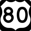 U.S. Route 80
 U.S. Route 319
 U.S. Route 441
 U.S. Route 441 Bypass (around Dublin)
 State Route 19
 State Route 26
 State Route 29
 State Route 31
 State Route 46
 State Route 86
 State Route 117
 State Route 126
 State Route 199
 State Route 257
 State Route 278
 State Route 338
 State Route 404 (unsigned designation for I-16)
Adjacent counties
- Johnson County – northeast
- Emanuel County – northeast
- Treutlen County – east
- Wheeler County – south
- Dodge County – southwest
- Bleckley County – west
- Wilkinson County – northwest
- Twiggs County – northwest
Demographics
| Historical population | |||
|---|---|---|---|
| Census | Pop. | %± | |
| 1810 | 2,210 | — | |
| 1820 | 5,436 | 146.0% | |
| 1830 | 5,589 | 2.8% | |
| 1840 | 5,585 | −0.1% | |
| 1850 | 6,442 | 15.3% | |
| 1860 | 6,998 | 8.6% | |
| 1870 | 7,834 | 11.9% | |
| 1880 | 10,053 | 28.3% | |
| 1890 | 13,747 | 36.7% | |
| 1900 | 25,908 | 88.5% | |
| 1910 | 35,501 | 37.0% | |
| 1920 | 39,605 | 11.6% | |
| 1930 | 32,693 | −17.5% | |
| 1940 | 33,606 | 2.8% | |
| 1950 | 33,123 | −1.4% | |
| 1960 | 32,313 | −2.4% | |
| 1970 | 32,738 | 1.3% | |
| 1980 | 36,990 | 13.0% | |
| 1990 | 39,988 | 8.1% | |
| 2000 | 44,874 | 12.2% | |
| 2010 | 48,434 | 7.9% | |
| 2018 (est.) | 47,325 | [7] | −2.3% |
| U.S. Decennial Census[8] 1790-1960[9] 1900-1990[10] 1990-2000[11] 2010-2013[1] | |||
2000 census
As of the census[12] of 2000, there were 44,874 people, 17,083 households, and 12,180 families living in the county. The population density was 55 people per square mile (21 per km2). There were 19,687 housing units at an average density of 24 per square mile (9 per km2). The racial makeup of the county was 63.44% White, 34.53% Black or African American, 0.20% Native American, 0.80% Asian, 0.03% Pacific Islander, 0.40% from other races, and 0.60% from two or more races. 1.18% of the population were Hispanic or Latino of any race.
There were 17,083 households, out of which 33.80% had children under the age of 18 living with them, 50.30% were married couples living together, 17.10% had a female householder with no husband present, and 28.70% were non-families. 25.70% of all households were made up of individuals, and 10.30% had someone living alone who was 65 years of age or older. The average household size was 2.55 and the average family size was 3.06.
In the county, the population was spread out, with 26.80% under the age of 18, 9.10% from 18 to 24, 28.00% from 25 to 44, 22.80% from 45 to 64, and 13.30% who were 65 years of age or older. The median age was 36 years. For every 100 females, there were 92.60 males. For every 100 females age 18 and over, there were 88.40 males.
The median income for a household in the county was $32,010, and the median income for a family was $38,586. Males had a median income of $29,412 versus $21,711 for females. The per capita income for the county was $16,763. About 14.70% of families and 18.40% of the population were below the poverty line, including 26.30% of those under age 18 and 18.90% of those age 65 or over.
2010 census
As of the 2010 United States Census, there were 48,434 people, 18,641 households, and 13,060 families living in the county.[13] The population density was 60.0 inhabitants per square mile (23.2/km2). There were 21,368 housing units at an average density of 26.5 per square mile (10.2/km2).[14] The racial makeup of the county was 60.6% white, 35.8% black or African American, 1.0% Asian, 0.2% American Indian, 1.2% from other races, and 1.2% from two or more races. Those of Hispanic or Latino origin made up 2.4% of the population.[13] In terms of ancestry, 14.9% were American, 7.0% were English, and 6.0% were Irish.[15]
Of the 18,641 households, 35.6% had children under the age of 18 living with them, 46.8% were married couples living together, 18.4% had a female householder with no husband present, 29.9% were non-families, and 26.2% of all households were made up of individuals. The average household size was 2.54 and the average family size was 3.05. The median age was 38.0 years.[13]
The median income for a household in the county was $38,280 and the median income for a family was $46,466. Males had a median income of $37,236 versus $27,406 for females. The per capita income for the county was $19,387. About 16.8% of families and 21.0% of the population were below the poverty line, including 28.7% of those under age 18 and 19.9% of those age 65 or over.[16]
Education
Laurens County School District operates the county's public schools.
Notable people
- Eugenia Tucker Fitzgerald, founder of the first woman's secret society established at a girls' college was born here.
- Karl Slover, one of the oldest living Munchkins from Wizard of Oz (1939 film).
- Demaryius Thomas, wide receiver for the Denver Broncos
Politics
| Year | Republican | Democratic | Third parties |
|---|---|---|---|
| 2020 | 63.8% 14,493 | 35.5% 8,073 | 0.7% 163 |
| 2016 | 63.6% 12,411 | 34.6% 6,752 | 1.9% 367 |
| 2012 | 60.9% 11,950 | 38.3% 7,513 | 0.9% 176 |
| 2008 | 60.4% 12,052 | 38.9% 7,769 | 0.7% 142 |
| 2004 | 63.1% 10,883 | 36.4% 6,281 | 0.6% 97 |
| 2000 | 57.9% 8,133 | 40.8% 5,724 | 1.3% 179 |
| 1996 | 47.8% 6,118 | 45.2% 5,792 | 7.0% 893 |
| 1992 | 43.7% 6,146 | 44.0% 6,184 | 12.3% 1,729 |
| 1988 | 57.9% 6,929 | 40.8% 4,879 | 1.4% 162 |
| 1984 | 56.8% 7,181 | 43.2% 5,471 | |
| 1980 | 35.1% 4,392 | 62.8% 7,860 | 2.2% 271 |
| 1976 | 27.6% 3,281 | 72.4% 8,617 | |
| 1972 | 77.5% 7,350 | 22.5% 2,130 | |
| 1968 | 21.3% 2,738 | 26.9% 3451 | 51.8% 6,649 |
| 1964 | 58.8% 5,457 | 41.2% 3,828 | 0.0% 2 |
| 1960 | 28.8% 1,884 | 71.2% 4,648 | |
| 1956 | 19.0% 1,189 | 81.1% 5,085 | |
| 1952 | 17.3% 1,046 | 82.7% 5,001 | |
| 1948 | 7.1% 268 | 61.1% 2,325 | 31.8% 1,211 |
| 1944 | 16.4% 498 | 83.6% 2,544 | |
| 1940 | 15.8% 435 | 84.1% 2,316 | 0.2% 4 |
| 1936 | 10.4% 304 | 89.4% 2,620 | 0.2% 7 |
| 1932 | 1.7% 38 | 98.3% 2,188 | 0.0% 1 |
| 1928 | 19.1% 470 | 80.9% 1,987 | |
| 1924 | 9.3% 121 | 86.8% 1,127 | 3.9% 51 |
| 1920 | 23.1% 350 | 76.9% 1,167 | |
| 1916 | 9.7% 143 | 86.0% 1,269 | 4.3% 64 |
| 1912 | 7.5% 92 | 90.5% 1,107 | 2.0% 24 |
References
- "State & County QuickFacts". United States Census Bureau. Archived from the original on July 2, 2011. Retrieved June 23, 2014.
- "Find a County". National Association of Counties. Retrieved June 7, 2011.
- Gannett, Henry (1905). The Origin of Certain Place Names in the United States. U.S. Government Printing Office. p. 182.
- Krakow, Kenneth K. (1975). Georgia Place-Names: Their History and Origins (PDF). Macon, GA: Winship Press. p. 130. ISBN 0-915430-00-2.
- "US Gazetteer files: 2010, 2000, and 1990". United States Census Bureau. February 12, 2011. Retrieved April 23, 2011.
- "Georgia Soil and Water Conservation Commission Interactive Mapping Experience". Georgia Soil and Water Conservation Commission. Retrieved November 27, 2015.
- "Population and Housing Unit Estimates". Retrieved July 31, 2019.
- "U.S. Decennial Census". United States Census Bureau. Retrieved June 23, 2014.
- "Historical Census Browser". University of Virginia Library. Retrieved June 23, 2014.
- "Population of Counties by Decennial Census: 1900 to 1990". United States Census Bureau. Retrieved June 23, 2014.
- "Census 2000 PHC-T-4. Ranking Tables for Counties: 1990 and 2000" (PDF). United States Census Bureau. Retrieved June 23, 2014.
- "U.S. Census website". United States Census Bureau. Retrieved May 14, 2011.
- "DP-1 Profile of General Population and Housing Characteristics: 2010 Demographic Profile Data". United States Census Bureau. Archived from the original on February 13, 2020. Retrieved December 30, 2015.
- "Population, Housing Units, Area, and Density: 2010 - County". United States Census Bureau. Archived from the original on February 13, 2020. Retrieved December 30, 2015.
- "DP02 SELECTED SOCIAL CHARACTERISTICS IN THE UNITED STATES – 2006-2010 American Community Survey 5-Year Estimates". United States Census Bureau. Archived from the original on February 13, 2020. Retrieved December 30, 2015.
- "DP03 SELECTED ECONOMIC CHARACTERISTICS – 2006-2010 American Community Survey 5-Year Estimates". United States Census Bureau. Archived from the original on February 13, 2020. Retrieved December 30, 2015.
- Leip, David. "Dave Leip's Atlas of U.S. Presidential Elections". uselectionatlas.org. Retrieved March 21, 2018.
Places adjacent to Laurens County, Georgia | ||||||||||
|---|---|---|---|---|---|---|---|---|---|---|
| ||||||||||
Municipalities and communities of Laurens County, Georgia, United States | ||
|---|---|---|
| Cities | Map of Georgia highlighting Laurens County | |
| Towns | ||
| Unincorporated communities | ||
| Ghost town | ||
| Footnotes | ‡This populated place also has portions in an adjacent county or counties | |
| ||
| Principal cities |  | |
|---|---|---|
| Municipalities | ||
| Other communities | ||
| Counties | ||
| CSA components | ||

| Authority control |
|---|