Khirbat Karraza
Chorazin (Greek: Χοραζίν /koʊˈreɪzɪn/; also Chorazain) or Korazim (Hebrew: כורזים; also Chorizim) was an ancient village in the Roman and Byzantine periods, best known from the Christian Gospels. It stood on the Korazim Plateau in the Galilee on a hill above the northern shore of the Sea of Galilee, two and a half miles from Capernaum.
Khirbat Karraza or Chorazin | |
|---|---|
Village | |
 Ancient synagogue at Chorazin | |
.jpg.webp) 1870s map 1870s map .jpg.webp) 1940s map 1940s map.jpg.webp) modern map modern map .jpg.webp) 1940s with modern overlay map 1940s with modern overlay mapA series of historical maps of the area around Khirbat Karraza (click the buttons) | |
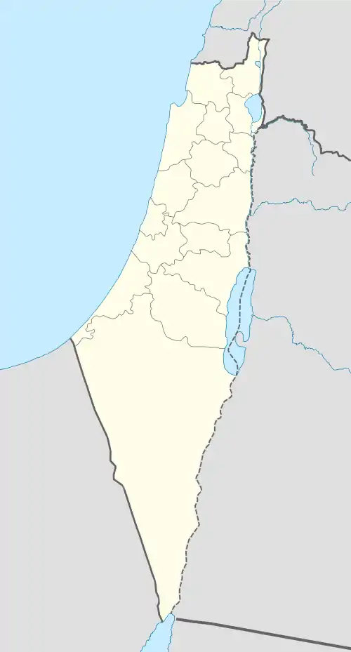
 Khirbat Karraza or Chorazin Location within Israel northeast | |
| Coordinates: 32°54′40″N 35°33′46″E | |
| Date of depopulation | May 4, 1948 |
Khirbat Karraza (also Karraza, Kh. Karazeh, Kerazeh) was an Arab village established at the site of the ancient village and depopulated during the 1947–1948 Civil War in Mandatory Palestine on May 4, 1948 by the Palmach's First Battalion during Operation Yiftach. It was located 8.5 km southeast of Safad.
The nearby Israeli town of Korazim is named for this location.
History
Gospels, apocrypha, exegesis
Chorazin, along with Bethsaida and Capernaum, was named in the gospels of Matthew and Luke as cities in which Jesus performed his mission. However, because these towns rejected his work ("they had not changed their ways"), they were subsequently cursed (Matthew 11:20–24; Luke 10:13–15). The gospels make no other mention of Chorazin or what works had occurred there. Due to the condemnation of Jesus, the influential Apocalypse of Pseudo-Methodius predicted that the Antichrist would be conceived in Chorazin.[1]
Theologian John Lightfoot (1602–1675) suggested that Chorazin might have been an area around Cana in Galilee, rather than a single city/village:
- What if, under this name, Cana be concluded, and some small country adjacent, which, from its situation in a wood, might be named "Chorazin", that is, 'the woody country'? Cana is famous for the frequent presence and miracles of Christ. But away with conjecture, when it grows too bold.[2]
Babylonian Talmud
The Babylonian Talmud (redacted until c. 475) mentions that Chorazin was a town known for its grain (Menahot, 85a).[3]
Scientific research
Two settlement phases have been proposed based on coin and pottery findings.[4]
The town was partially destroyed in the 4th century, possibly as a result of an earthquake.[5]
Ottoman period
.jpg.webp)
Khirbat Karraza was populated by the Zanghariyya Bedouin tribe and the village contained a shrine for a local Muslim saint, al-Shaykh Ramadan. The villagers used to store grain close to the shrine, certain that nobody would steal it and thereby violate the sanctity of the shrine.[6]
Israel
The Palestinian historian Walid Khalidi described the place in 1992: "The site serves as an archaeological and tourist area. Some village houses still stand, together with the remains of other houses. One of the old houses has been renovated. Also remaining is the tomb of Shaykh Ramadan, around which the village shrine had been built. The tomb is collapsing and the building in which it was housed no longer exists. It is surrounded by large carob trees."[6]
Archaeology


19th-century explorers
In his Biblical Researches in Palestine in the mid-nineteenth century, Edward Robinson visited Khirbat Karraza, but concluded it was not the Biblical Chorazin, because the ruins were not significant enough and the site was not near the shore of the Sea of Galilee, as stated by Jerome (Lacum Genesareth, in cujus litore Capernaum et Tiberias et Bethsaida et Chorozaim sitæ sint):[7]
The ruins we had been told of lie on the west side of this same valley, a quarter of a mile southwest, near its entrance into the main Wady. They consist simply of a few foundations of black stones ; the remains evidently of a poor and inconsiderable village. They are known as Khirbet Kerâzeh. We did not go to them, as there was no path; and because they were in full view. Their distance from Tell Hùm must be reckoned at about three miles. We had come to this spot, because the name Kerázeh bears a degree of resemblance to the Chorazin of the New Testament; and we hoped to find, in the ruins or the situation, something which might determine the position of that ancient place. In this we felt ourselves disappointed. The remains are too trivial to have ever belonged to a place of any importance. Chorazin, too, according to Jerome, lay upon the shore of the lake; but this site is an hour distant. shut in among the hills, without any view of the lake, and remote from any public road whether ancient or modern.
Excavations and general outline
Extensive excavations and a survey were carried out in 1962-1964. Excavations at the site were resumed in 1980-1987.
In May–June 2004, a small-scale salvage excavation was conducted by the Israel Antiquities Authority along the route of an ancient road north of Moshav Amnun. In the literature, the road is referred to as "the way through Korazim." It crossed the Chorazin plateau from west to east, branching off from the main Cairo–Damascus road that ran northeast toward Daughters of Jacob Bridge.[8]
The majority of the structures are made from basalt, a black volcanic rock found locally.[9]
The main settlement dates to the 3rd and 4th centuries.
The town's ruins are spread over an area of 25 acres (100,000 m2), subdivided into five separate quarters, with a synagogue in the centre. Close by is a ritual bath (mikvah), surrounded by public and residential buildings.
Synagogue
The only synagogue visible today was built in the late 3rd century, destroyed in the 4th century, and rebuilt in the 6th century.[10]
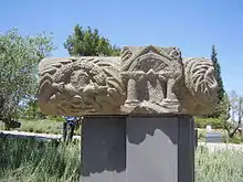
The large, impressive synagogue which was built of basalt stones and decorated with Jewish motifs is the most striking of the surviving structures.
An unusual feature in an ancient synagogue is the presence of three-dimensional sculpture, a pair of stone lions. A similar pair of three-dimensional lions was found in the synagogue at Kfar Bar'am.[11] Other carvings, which are thought to have originally been brightly painted, feature images of wine-making, animals, a Medusa, an armed soldier, and an eagle.[12]
In 1926, archaeologists discovered the "Seat of Moses," carved from a basalt block. According to the New Testament, this is where the reader of the Torah sat (Matthew 23:1-3).[3]
Second synagogue (?)
Jacob Ory, who excavated the site in 1926 on behalf of the British Mandate Department of Antiquities, wrote about a second synagogue ca. 200 m west of the first one, and he described it in detail. Later excavations, however, have not been able to find the remains noted by him.[13]
Other findings
The handful of olive millstones used in olive oil extraction found suggest a reliance on the olive for economic purposes, like a number of other villages in ancient Galilee.
Reference
The scholar and author M.R. James mentions "Chorazin" as a place of ill-repute and a location on "the black pilgrimage", in his 1904 short story, "Count Magnus".
See also
- Ancient synagogues in the Palestine region
- Archaeology of Israel
- Jesus trail
- National parks of Israel
- Oldest synagogues in the world
- Woes to the unrepentant cities, pronounced by Jesus and which included Chorazin
References
- Alexander, Paul Julius (1985). The Byzantine Apocalyptic Tradition. pp. 195–196. ISBN 0520049985.
- Lightfoot, J., A Commentary on the New Testament From the Talmud and Hebraica: Matthew, accessed 6 January 2017
- "Three Woes". Archived from the original on 2016-03-10. Retrieved 2016-03-10.
- Jews and Christians in the Holy Land: Palestine in the Fourth Century
- Stemberger, 2000, pp.141-142
- Khalidi, 1992, p. 462
- Smith, Eli (1856). Biblical Researches in Palestine, and in the Adjacent Regions: A Journal of Travels in the Year 1838. Crocker and Brewster. p. 347.
- Kh. Umm el-Kalkha
- Hachlili, Rachel. Ancient Jewish Art and Archaeology in the Land of Israel
- Avraham Negev; Shimon Gibson (July 2005). Archaeological encyclopedia of the Holy Land. Continuum International Publishing Group. p. 118. ISBN 978-0-8264-8571-7. Retrieved 15 May 2011.
- Steven Fine (2005). Art and Judaism in the Greco-Roman world: toward a new Jewish archaeology. Cambridge University Press. ISBN 978-0-521-84491-8. Retrieved 15 May 2011. p.190
- Steven Fine (2005). Art and Judaism in the Greco-Roman world: toward a new Jewish archaeology. Cambridge University Press. ISBN 978-0-521-84491-8. Retrieved 15 May 2011. p.92
- Anders Runesson; Donald D. Binder; Birger Olsson (2008). The Ancient Synagogue from its Origins to 200 C.E.. Brill. p. 32. ISBN 978-90-04-16116-0.
Bibliography
- Khalidi, W. (1992). All That Remains: The Palestinian Villages Occupied and Depopulated by Israel in 1948. Washington D.C.: Institute for Palestine Studies. ISBN 0-88728-224-5.
- Morris, B. (2004). The Birth of the Palestinian Refugee Problem Revisited. Cambridge University Press. ISBN 978-0-521-00967-6.
- Stemberger, Günter (2000). Jews and Christians in the Holy Land: Palestine in the fourth century. Continuum International Publishing Group. ISBN 978-0-567-08699-0. Retrieved 15 May 2011.
- Z. Yeivin, The Synagogue at Korazim; The 1962 - 1964, 1980 - 1987 Excavations, Israel Antiquities Authority Reports, Israel Antiquities Authority, 2000.
- New Encyclopedia of Archaeological Excavations in the Holy Land vols. 1-5. Ed. E. Stern; Jerusalem: Israel Exploration Society and Carta (1993-2008).
External links
| Wikimedia Commons has media related to Khirbat Karraza. |
- Welcome To Khirbat Karraza
- Khirbat Karraza, Zochrot
- Karraza at Khalil Sakakini Cultural Center
- Chorazin—Sitting in the Seat but Missing the Message from waynestiles.com
- Strong's G5523
- Pictures of Chorazin
- The Ancient Synagogue of Chorazin from a Jewish tourism site
- Chorazin University of Notre Dame, New Testament Professor David E. Aune
- Ancient Chorazin Comes Back to Life by Ze’ev Yeivin of the Biblical Archaeology Society.
| Jerusalem District |
| ||||
|---|---|---|---|---|---|
| Northern District | |||||
| Haifa District | |||||
| Central District |
| ||||
| Tel Aviv District | |||||
| Southern District |
| ||||
| Judea and Samaria Area |
| ||||
Located in the Israeli-occupied territories - East Jerusalem1, the Golan Heights2, and the West Bank3 ♦ See also: Nature reserves of Israel | |||||