Bashshit
Bashshit (Arabic: بشيت), also Beshshit, was a Palestinian Arab village in the Ramle Subdistrict, located 16.5 kilometers (10.3 mi) southwest of Ramla about half a mile from wadi Bashshit. Archaeological artifacts from the village attest to habitation in the Early Islamic period and 12th and 13th centuries. Mentioned by Arab geographers from the 13th century onward, there was a tomb for the Neby Shit ("prophet Seth") in the village.
Bashshit
بشيت Beshshit, Beit Shit | |
|---|---|
 | |
| Etymology: "House of Seth"[1] | |
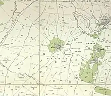
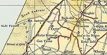
.jpg.webp) 1870s map 1870s map .jpg.webp) 1940s map 1940s map.jpg.webp) modern map modern map .jpg.webp) 1940s with modern overlay map 1940s with modern overlay mapA series of historical maps of the area around Bashshit (click the buttons) | |
 Bashshit Location within Mandatory Palestine | |
| Coordinates: 31°49′27″N 34°44′56″E | |
| Palestine grid | 126/136 |
| Geopolitical entity | Mandatory Palestine |
| Subdistrict | Ramle |
| Date of depopulation | May 13, 1948[2] |
| Area | |
| • Total | 18,553 dunams (18.6 km2 or 7.2 sq mi) |
| Population (1945) | |
| • Total | 1,620[3][4] |
| Cause(s) of depopulation | Military assault by Yishuv forces |
| Current Localities | Neve Mivtah[5] Meshar,[5] Kfar Mordechai,[5] Misgav Dov,[5] Kannot,[5] Shedema,[5] and Aseret.[5] |
Like much the rest of Palestine, Bashshit was ruled by the Crusaders, Mamluks, Ottomans and the British. It was depopulated at the beginning of the 1948 Palestine war during Operation Barak. Along with the villages of Barqa, Bayt Daras, al-Batani al-Sharqi, and al-Maghar, among others, Bashshit was attacked by Haganah's Givati Brigade.[6] Following its depopulation, Bashshit was mostly destroyed. There are seven Israeli localities now situated on what were the village lands.
Etymology
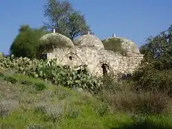
According to the Palestine Exploration Fund, Beshshit stands for Beit Shit, meaning "house of Seth.[7] The tomb of Neby Shit ("prophet Seth") was in Bashshit, and other sanctuaries for him in the region included one in Samaria (Haram en Neby Shit), as well as Al-Nabi Shayth further north in Lebanon.[8] The tomb lies within a triple-domed mosque of the same name located on the side of a hill that lay in the center of the former village.[9]
History
Pottery remains from the early Islamic era[10] and a coin from the Umayyad era (697–750 CE) have been found here,[11] together with pottery remains from the 12th–13th centuries CE.[10]
During the Crusader period in Palestine, Bashshit was referred to as Basit. It is documented in the writings of Yaqut al-Hamawi (died 1228) who mentioned it in his Mu'jam, describing its proximity to al-Ramla.[5][12]
Coins from the Mamluk era (14th century CE) have been found here.[11]
Ottoman era
Ibn al-Imad al-Hanbali gave an account of the village in the 17th century, noting that the Arab scholar Jamal al-Bashshiti (d.1417) was from the village.[5]
In 1838 it was noted as a village, Beshit, in the Gaza district.[13]
In May 1863 Victor Guérin found the village to have 350 inhabitants, surrounded by tobacco fields,[14] while an Ottoman village list of about 1870 showed that Bashshit had a population of 159, with a total of 57 houses, though the population count included men only. It was also noted that the name came from "House of Seth".[15][16]
In the late 19th century, while under Ottoman rule, Bashshit was an important village between Yibna and Isdud.[9] The village structures in Bashshit were made of adobe bricks. There were cultivated gardens with cactus hedges, and on a hill, stood a three-domed shrine.[5][9][17]
At the end of WWI there apparently was some fighting in/around Bashshit, as used ammunition dating from that era have been found. The New Zealand Mounted Rifles Brigade operated in the area in 1917.[11]
British Mandate era
During the British Mandate period, Bashshit had an elementary school, built in 1921, in which 148 students were enrolled in the mid-1940s. The village had a mosque and several artesian wells. Most of the residents were farmers.[5]
In the 1922 census of Palestine conducted by the British Mandate authorities, Bashit had a population of 936; all Muslims,[18] increasing in the 1931 census to 1,125, still all Muslims, in a total of 333 houses.[19] By 1945, the population had increased to 1,620, the population being entirely Arab in ethnicity. The village comprised a total area of 18,553 dunums.[4]
A large number of inhabitants were employed in cereal farming, which occupied most of the land area. Some land was also allocated for irrigation and plantation, and the growing of citrus fruits and olives.[5][20]
|
Types of landuse in dunams by Arabs in the 1945 statistics:[20][21]
|
The land ownership of the village before occupation in dunams:[4]
|
1948 War and aftermath
Between May 10 and May 13, 1948, the village was attacked by the 52nd and 53rd battalions of the Givati Brigade as part of Operation Barak. The villagers put up a major struggle, but the houses were mostly all destroyed.[22]
Today, there are seven Israeli settlements on the village land, including Newe Mivtach, Meshar, Kfar Mordechai, Misgav Dov, Kannot, Shedema, and Aseret. Of Bashshit's former structures, three houses and a pool remain; two of the houses are deserted and an Israeli family occupies one. The surrounding lands today are cultivated by Israelis for agricultural production.[23]
The village contains an archaeological site, al-Nabi 'Ararat, which has some remaining pillars and cisterns. However, the site is fenced off and marked as a "dangerous building" and the cisterns are heavily populated with bats.[24] The remains of a courtyard in front of the khirbat ("ruins") is heavily overgrown with weeds.
Excavations
In 1999, the village became subject of an archaeological investigation by the Israel Antiquities Authority. The excavation, directed by T. Kanias, with the assistance of A. Hajian (surveying), R. Graff (drafting) and M. Saltzberger (photography) involved the excavation of the sewer line which revealed building remains and ceramic fragments from the Early Islamic period and the 12th–13th centuries CE.[10] Various sized kurkar stones were discovered 0.9 m below the surface, pottery fragments from the Early Islamic period and a few animal bones.[10] Numerous potsherds were excavated also dating to the 12th–13th centuries CE, including the foot of a clay box lined with chalk and decorated with a geometric pattern and the remains of a plaster floor.[10]
A salvage excavation in 2016 revealed remains from the Umayyad, Mamluk and Ottoman era.[11]
References
- Palmer, 1881, p. 266
- Morris, 2004, p. xix, village #257. Also gives cause of depopulation
- Government of Palestine, Department of Statistics, 1945, p. 29
- Government of Palestine, Department of Statistics. Village Statistics, April, 1945. Quoted in Hadawi, 1970, p. 66
- Khalidi, 1992, p. 363
- Khalidi, 1992, p.85
- Stewardson, 1888, p. 84
- Conder, 1877, p. 93
- Petersen, 2001, p. 110
- Kanias, 2004, Bashshit Final Report
- Elad, 2017, Bashshit/‘Aseret
- Le Strange, 1890, p. 421
- Robinson and Smith, 1841, vol 3, 2nd appendix, p. 118
- Guérin, 1869, p. 66
- Socin, 1879, p. 144 Also noted that it was located in the Gaza district
- Hartmann, 1883, p. 134 also noted 57 houses
- Conder and Kitchener, 1882, SWP II, p. 409
- Barron, 1923, Table V, Sub-district of Gaza, p. 9
- Mills, 1932, p. 2.
- Government of Palestine, Department of Statistics. Village Statistics, April, 1945. Quoted in Hadawi, 1970, p. 114
- Government of Palestine, Department of Statistics. Village Statistics, April, 1945. Quoted in Hadawi, 1970, p. 164
- Morris, 2004, p. 256
- "Destroyed villages:Bashshit". www.alnakba.org. Archived from the original on May 27, 2010. Retrieved August 22, 2009.
- Tracing all that remains of the destroyed village of Bashshit -Palestine
Bibliography
- Barron, J.B., ed. (1923). Palestine: Report and General Abstracts of the Census of 1922. Government of Palestine.
- Conder, C.R. (1877). "The Moslem Mukam". Quarterly statement - Palestine Exploration Fund. 9: 89–103.
- Conder, C.R.; Kitchener, H.H. (1882). The Survey of Western Palestine: Memoirs of the Topography, Orography, Hydrography, and Archaeology. 2. London: Committee of the Palestine Exploration Fund.
- Elad, Itai (2017-07-09). "Bashshit Final Report" (129). Hadashot Arkheologiyot – Excavations and Surveys in Israel. Cite journal requires
|journal=(help) - Government of Palestine, Department of Statistics (1945). Village Statistics, April, 1945.
- Guérin, V. (1869). Description Géographique Historique et Archéologique de la Palestine (in French). 1: Judee, pt. 2. Paris: L'Imprimerie Nationale.
- Hadawi, S. (1970). Village Statistics of 1945: A Classification of Land and Area ownership in Palestine. Palestine Liberation Organization Research Center.
- Hartmann, M. (1883). "Die Ortschaftenliste des Liwa Jerusalem in dem türkischen Staatskalender für Syrien auf das Jahr 1288 der Flucht (1871)". Zeitschrift des Deutschen Palästina-Vereins. 6: 102–149.
- Kanias, Tzach (2004-05-31). "Bashshit Final Report" (116). Hadashot Arkheologiyot – Excavations and Surveys in Israel. Cite journal requires
|journal=(help) - Khalidi, W. (1992). All That Remains: The Palestinian Villages Occupied and Depopulated by Israel in 1948. Washington D.C.: Institute for Palestine Studies. ISBN 0-88728-224-5.
- Le Strange, G. (1890). "Palestine Under the Moslems: A Description of Syria and the Holy Land from A.D. 650 to 1500". Committee of the Palestine Exploration Fund. Cite journal requires
|journal=(help) - Mills, E., ed. (1932). Census of Palestine 1931. Population of Villages, Towns and Administrative Areas. Jerusalem: Government of Palestine.
- Morris, B. (2004). The Birth of the Palestinian Refugee Problem Revisited. Cambridge University Press. ISBN 978-0-521-00967-6.
- Palmer, E.H. (1881). The Survey of Western Palestine: Arabic and English Name Lists Collected During the Survey by Lieutenants Conder and Kitchener, R. E. Transliterated and Explained by E.H. Palmer. Committee of the Palestine Exploration Fund.
- Petersen, Andrew (2002). A Gazetteer of Buildings in Muslim Palestine: (British Academy Monographs in Archaeology). I. Oxford University Press. ISBN 978-0-19-727011-0.
- Robinson, E.; Smith, E. (1841). Biblical Researches in Palestine, Mount Sinai and Arabia Petraea: A Journal of Travels in the year 1838. 3. Boston: Crocker & Brewster.
- Socin, A. (1879). "Alphabetisches Verzeichniss von Ortschaften des Paschalik Jerusalem". Zeitschrift des Deutschen Palästina-Vereins. 2: 135–163.
- Stewardson, Henry C., ed. (1888). The Survey of Western Palestine, Index. Committee of the Palestine Exploration Fund.
External links
- Welcome to Bashshit
- Bashshit, Zochrot
- Survey of Western Palestine, Map 16: IAA, Wikimedia commons
- Bashshit at Khalil Sakakini Cultural Center
- Tomb of Nabi Shit (Prophet Seth)
- YouTube video