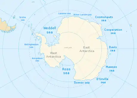
Lazarev Sea
The Lazarev Sea (Russian: Море Лазарева, More Lazareva) is a proposed name for a marginal sea of the Southern Ocean. It would be bordered by two proposals from a 2002 International Hydrographic Organization (IHO) draft, a King Haakon VII Sea to the west and a Riiser-Larsen Sea to the east, or between the Prime Meridian of 0° and 14°E. It would stretch over an area of 929,000 km2 (359,000 sq mi).[1]
The Lazarev Sea was named in 1962 by the Soviet Antarctic Expedition in honor of Russian admiral Mikhail Lazarev (1788–1851), who discovered the Antarctic mainland with Fabian Gottlieb von Bellingshausen in 1820. The 2002 IHO draft was never approved by the IHO (or any other organization), and the 1953 IHO document (which does not contain this name) remains currently in force.[2] Leading geographic authorities and atlases do not use the name, including the 2014 10th edition World Atlas from the United States' National Geographic Society and the 2014 12th edition of the British Times Atlas of the World. But Soviet and Russian-state maps do.[3]
The prevailing depth of waters here is 3,000 m (9,800 ft), and the maximum depth exceeds 4,500 m (14,800 ft). It stretches over an area of 929,000 km2 (359,000 sq mi).[1]
To the south of Lazarev Sea lies Princess Astrid Coast of Queen Maud Land.
References
- Lazarev Sea from The Great Soviet Encyclopedia(1979) cited via The Free Diectionary
- "Limits of Oceans and Seas, 3rd (currently in-force) edition" (PDF). International Hydrographic Organization. 1953. Archived from the original (PDF) on 8 October 2011. Retrieved 28 December 2020.